- Dunstable, Massachusetts
-
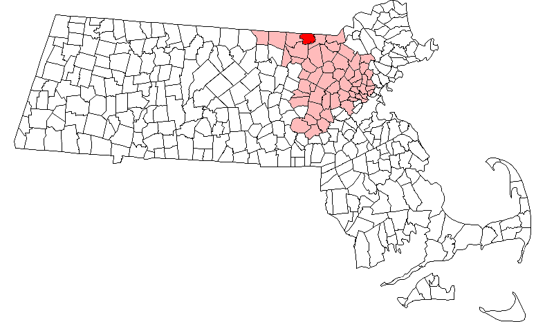
Dunstable, Massachusetts — Town — Pleasant Street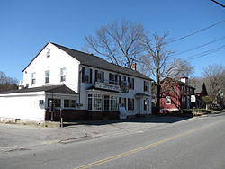 Location in Middlesex County in Massachusetts
Coordinates: 42°40′30″N 71°29′00″W / 42.675°N 71.4833333°WCoordinates: 42°40′30″N 71°29′00″W / 42.675°N 71.4833333°W Country United States State Massachusetts County Middlesex Settled 1656 Incorporated 1673 Government – Type Open town meeting Area – Total 16.7 sq mi (43.4 km2) – Land 16.6 sq mi (42.9 km2) – Water 0.2 sq mi (0.5 km2) Elevation 224 ft (68 m) Population (2010) – Total 3,179 – Density 198.2/sq mi (76.7/km2) Time zone Eastern (UTC-5) – Summer (DST) Eastern (UTC-4) ZIP code 01827 Area code(s) 351 / 978 FIPS code 25-17825 GNIS feature ID 0618222 Website http://www.dunstable-ma.gov/ Dunstable (
 /ˈdʌnstəbəl/ dun-stə-bəl) is a town in Middlesex County, Massachusetts, United States. The population was 3,179 at the 2010 census.
Contents
Etymology
Main article: DunstableDunstable was named after its sister town Dunstable, UK.
- Legend tells that the lawlessness of the time was personified in a thief called Dun. Wishing to capture Dun, the King stapled his ring to a post daring the robber to steal it. It was, and was subsequently traced to the house of the widow Dun. Her son, the robber, was taken and hanged to the final satisfaction that the new community bore his name.[1]
- It comes from the Anglo-Saxon for "the boundary post of Duna".[1][2]
- Derived from Dunum, or Dun, a hill, and Staple, a marketplace.[3]
History
Dunstable was first settled in 1656 and was officially incorporated in 1673. It is likely named after the town of Dunstable in Bedfordshire, England, United Kingdom, home of Edward Tyng, the town's first settler. The original township of Dunstable, granted in 1661, consisted of two hundred square miles, including the towns of Dunstable, Tyngsborough, Massachusetts, Pepperell, Massachusetts, Townsend, Massachusetts, Hudson, New Hampshire, Nashua, New Hampshire, Hollis, New Hampshire, and parts of other towns as well. Increases in population leading to subsections becoming independent towns and the solidification of the Northern boundary of Massachusetts in 1740 shrunk the town down to what remains today.
Today, Dunstable, in the face of urban sprawl, has held onto a largely rural character.
Geography
According to the United States Census Bureau, the town has a total area of 16.7 square miles (43 km2), of which, 16.5 square miles (43 km2) of it is land and 0.2 square miles (0.52 km2) of it (1.13%) is water. Dunstable borders Pepperell to the west, Groton to the south, Tyngsborough to the east, and Nashua and Hollis, New Hampshire to the north.
Demographics
Historical populations Year Pop. ±% 1850 590 — 1860 487 −17.5% 1870 471 −3.3% 1880 453 −3.8% 1890 416 −8.2% 1900 427 +2.6% 1910 408 −4.4% 1920 353 −13.5% 1930 384 +8.8% 1940 447 +16.4% 1950 522 +16.8% 1960 824 +57.9% 1970 1,292 +56.8% 1980 1,671 +29.3% 1990 2,236 +33.8% 2000 2,829 +26.5% 2001* 2,939 +3.9% 2002* 2,994 +1.9% 2003* 3,057 +2.1% 2004* 3,110 +1.7% 2005* 3,170 +1.9% 2006* 3,233 +2.0% 2007* 3,306 +2.3% 2008* 3,342 +1.1% 2009* 3,387 +1.3% 2010 3,179 −6.1% * = population estimate.
Source: United States Census records and Population Estimates Program data.[4][5][6][7][8][9][10][11][12][13]As of the census[14] of 2000, there were 2,826 people, 923 households, and 798 families residing in the town. The population density was 171.0 people per square mile (66.0/km²). There were 944 housing units at an average density of 57.0 per square mile (22.0/km²). The racial makeup of the town was 97.49% White, 0.11% African American, 0.04% Native American, 1.52% Asian, 0.07% from other races, and 0.78% from two or more races. Hispanic or Latino of any race were 0.53% of the population.
There were 923 households out of which 47.5% had children under the age of 18 living with them, 76.7% were married couples living together, 7.2% had a female householder with no husband present, and 13.5% were non-families. 10.3% of all households were made up of individuals and 3.7% had someone living alone who was 65 years of age or older. The average household size was 3.07 and the average family size was 3.31.
In the town the population was spread out with 31.1% under the age of 18, 4.4% from 18 to 24, 31.4% from 25 to 44, 26.2% from 45 to 64, and 6.8% who were 65 years of age or older. The median age was 37 years. For every 100 females there were 97.7 males. For every 100 females age 18 and over, there were 93.3 males.
The median income for a household in the town was $86,633, and the median income for a family was $92,270. Males had a median income of $61,425 versus $39,946 for females. The per capita income for the town was $30,608. About 2.1% of families and 1.9% of the population were below the poverty line, including 2.4% of those under age 18 and 2.1% of those age 65 or over.
Education
District Schools
Main article: Groton-Dunstable Regional School District- Boutwell School
- Swallow Union Elementary School
- Florence Roche Elementary School
- Groton-Dunstable Regional Middle School
- Groton-Dunstable Regional High School
- Prescott Elementary School (Closed after the 2007-2008 school year due to budget cuts)[15]
Other Public Schools
- Greater Lowell Technical High School- Public Regional Technical High School in Tyngsboro, Massachusetts
Points of interest
-
This list is incomplete; you can help by expanding it.
- "The Little Red Schoolhouse" is a historical building located on route 113 near the Tyngsboro border. This school house originally came from Tyngsboro. Local students take field trips there to historically re-enact a school day. An annual Strawberry Festival is also held there. Boy Scout Troop 28 of Dunstable holds a Mother’s Day pancake breakfast there every year.
- The "Sarah R S Roby" Town Hall in located at 511 Main St (Rt. 113) was built in 1909 and renovated in 2003. Most town offices are located here as well as meeting rooms for various meetings and events.
- The Town Commons across from the Dunstable Town Hall on Rt. 113 is the site of many town events including the Summer Fest Carnival sponsored by the Dunstable-Tyngsboro Lion's Club in June, the summer "Concerts on the Common" live performance series and the Grange Fair in August. This is also the site for the annual auto show in Dunstable.
- The Dunstable Evangelical Congregational Church (DECC) is located at 518 Main St, adjacent to the Town Commons and directly across from Town Hall. While the congregation was established in that location in 1831, the current building dates from the early 1900s. Because it is the only church in town, it is often called simply "the Dunstable Church".
- The Dunstable Free Library is located at 588 Main St. In addition to the collection of books, periodicals, movies, children’s activities and historic items (which include a collection of typewriters and misc. Girl Scouting materials) , it is the site of many community activities as well as the site for town elections.
Notable residents
- Isaac Fletcher (1784–1842), United States Representative from Vermont
- Amos Kendall (1789–1869), United States Postmaster General during the administration of Andrew Jackson
- Amos Lawrence (1786–1852), merchant and philanthropist
- Samuel Parris (1653–1720), Puritan minister during the Salem witch trials
- Ellen Swallow Richards (1842–1911), chemist, first woman admitted to MIT
Trivia
- Dunstable is a dry town. No liquor is sold in either of the town's two small general stores.
- The Dunstable Town Hall once housed both Police Department, and Library, though recent renovations in the town gave construct to dedicated buildings for each.
- There are no traffic lights in Dunstable due to the low amounts of traffic.
References
- ^ a b Adrian Room, ed., Brewer's dictionary of Fame and Fable (1st ed.), ISBN 0-304-34869-4
- ^ Sunday Times Travel, 6 January 2008, p. p46
- ^ Genuki entry for Dunstable, Accessed 26_12_09
- ^ "TOTAL POPULATION (P1), 2010 Census Summary File 1, All County Subdivisions within Massachusetts". United States Census Bureau. http://factfinder2.census.gov/bkmk/table/1.0/en/DEC/10_SF1/P1/0400000US25.06000. Retrieved September 13, 2011.
- ^ "Massachusetts by Place and County Subdivision - GCT-T1. Population Estimates". United States Census Bureau. http://factfinder.census.gov/servlet/GCTTable?_bm=y&-geo_id=04000US25&-_box_head_nbr=GCT-T1&-ds_name=PEP_2009_EST&-_lang=en&-format=ST-9&-_sse=on. Retrieved July 12, 2011.
- ^ "1990 Census of Population, General Population Characteristics: Massachusetts". US Census Bureau. December 1990. Table 76: General Characteristics of Persons, Households, and Families: 1990. 1990 CP-1-23. http://www.census.gov/prod/cen1990/cp1/cp-1-23.pdf. Retrieved July 12, 2011.
- ^ "1980 Census of the Population, Number of Inhabitants: Massachusetts". US Census Bureau. December 1981. Table 4. Populations of County Subdivisions: 1960 to 1980. PC80-1-A23. http://www2.census.gov/prod2/decennial/documents/1980a_maABC-01.pdf. Retrieved July 12, 2011.
- ^ "1950 Census of Population". Bureau of the Census. 1952. Section 6, Pages 21-10 and 21-11, Massachusetts Table 6. Population of Counties by Minor Civil Divisions: 1930 to 1950. http://www2.census.gov/prod2/decennial/documents/23761117v1ch06.pdf. Retrieved July 12, 2011.
- ^ "1920 Census of Population". Bureau of the Census. Number of Inhabitants, by Counties and Minor Civil Divisions. Pages 21-5 through 21-7. Massachusetts Table 2. Population of Counties by Minor Civil Divisions: 1920, 1910, and 1920. http://www2.census.gov/prod2/decennial/documents/41084506no553ch2.pdf. Retrieved July 12, 2011.
- ^ "1890 Census of the Population". Department of the Interior, Census Office. Pages 179 through 182. Massachusetts Table 5. Population of States and Territories by Minor Civil Divisions: 1880 and 1890. http://www2.census.gov/prod2/decennial/documents/41084506no553ch2.pdf. Retrieved July 12, 2011.
- ^ "1870 Census of the Population". Department of the Interior, Census Office. 1872. Pages 217 through 220. Table IX. Population of Minor Civil Divisions, &c. Massachusetts. http://www2.census.gov/prod2/decennial/documents/1870e-05.pdf. Retrieved July 12, 2011.
- ^ "1860 Census". Department of the Interior, Census Office. 1864. Pages 220 through 226. State of Massachusetts Table No. 3. Populations of Cities, Towns, &c.. http://www2.census.gov/prod2/decennial/documents/1860a-08.pdf. Retrieved July 12, 2011.
- ^ "1850 Census". Department of the Interior, Census Office. 1854. Pages 338 through 393. Populations of Cities, Towns, &c.. http://www2.census.gov/prod2/decennial/documents/1850c-11.pdf. Retrieved July 12, 2011.
- ^ "American FactFinder". United States Census Bureau. http://factfinder.census.gov. Retrieved 2008-01-31.
- ^ "Prescott Home Page". http://www.gdrsd.org/Schools/Prescott/PRMain.html.
Further reading
- Nason, Elias and George Bailey Loring. A History of the Town of Dunstable, Massachusetts. A. Mudge: 1877.
- 1871 Atlas of Massachusetts. by Wall & Gray. Map of Massachusetts. Map of Middlesex County.
- History of Middlesex County, Massachusetts, Volume 1 (A-H), Volume 2 (L-W) compiled by Samuel Adams Drake, published 1879-1880. 572 and 505 pages. Dunstable article by Rev. Elias Nason in volume 1 pages 416-427.
External links
Municipalities and communities of Middlesex County, Massachusetts Cities 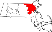
Towns Acton | Arlington | Ashby | Ashland | Ayer | Bedford | Belmont | Billerica | Boxborough | Burlington | Carlisle | Chelmsford | Concord | Dracut | Dunstable | Framingham | Groton | Holliston | Hopkinton | Hudson | Lexington | Lincoln | Littleton | Maynard | Natick | North Reading | Pepperell | Reading | Sherborn | Shirley | Stoneham | Stow | Sudbury | Tewksbury | Townsend | Tyngsborough | Wakefield | Wayland | Westford | Weston | Wilmington | Winchester
CDPs Ayer | Cochituate | Fort Devens | East Pepperell | Groton | Hopkinton | Hudson | Littleton Common | Pepperell | Pinehurst | Shirley | Townsend | West Concord
Other
villagesAuburndale | Chestnut Hill | Gleasondale | Nabnasset | Newton Centre | Newton Highlands | Newton Lower Falls | Newton Upper Falls | Newtonville | Nonantum | North Billerica | North Chelmsford | Waban | West Newton
Categories:- Towns in Middlesex County, Massachusetts
- Populated places established in 1656


Wikimedia Foundation. 2010.