- Northern boundary of Massachusetts
-
The northern boundary of the U.S. state of Massachusetts adjoins two other states - Vermont and New Hampshire. The majority of the line is roughly a straight line from the northwest corner of the state (42°44′44.7″N 73°15′54.13″W / 42.74575°N 73.2650361°W NAD27[1]) east to a point north of Lowell. East of that point, the border is a series of lines about 3 miles (5 km) north of the curving Merrimack River, ending in the Atlantic Ocean.
History
The 1629 charter of the Massachusetts Bay Colony gave the colony the land between the Merrimack River and Charles River. Specifically, the southern border was to be the line of latitude either 3 miles (4.8 km) south of Massachusetts Bay or 3 miles south of the southernmost bend of the Charles River, whichever was farther south. The northern border was to be 3 miles north of the northernmost bend of the Merrimack River. Between these lines of latitude the grant extended from the Atlantic to the Pacific. In 1629 the rivers had not been fully explored and the actual borders of the colony were uncertain. It turned out that the southernmost bend of the Charles is south of the southern curve of Massachusetts Bay. The line of latitude three miles south of the river's southernmost bend, approximately 42°2′ north, forms the basis of the southern border of Massachusetts to the present day. The Merrimack River turned out to originate farther north than expected, flowing south for most of its course and only turning eastward in its last several miles. Thus the 1629 grant gave the colony most of what is today New Hampshire and all of the original 1629 grant that formed the basis of colonial New Hampshire, but it took many decades before this was fully understood.[2]
A new charter was granted to the Province of Massachusetts Bay in 1691, which merged the Colony with the Colony of New Plymouth, as well as present-day Maine and New Brunswick. The northern boundary of what was now the southern piece remained as defined in 1629.[1]
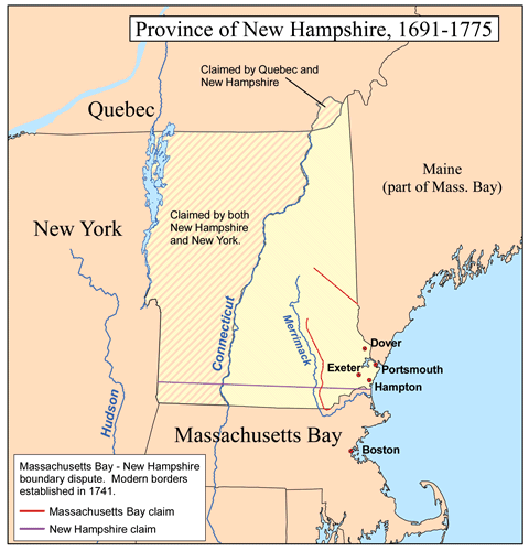
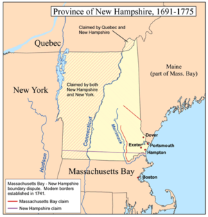 A map showing the rival claims of Massachusetts Bay and New Hampshire.
The Province of New Hampshire and Province of Massachusetts Bay had disagreements over their mutual boundaries. With respect to the southern boundary of New Hampshire, the two provinces disagreed on the meaning of "three miles northward of the Merrimack River, or any part thereof". New Hampshire drew a line from three miles north of the mouth of the river, while Massachusetts claimed a line three miles north of the northernmost part of the river, taking its territory far north past what is now Concord, New Hampshire. New Hampshire appealed to King George II, who in 1740 decreed the boundary to run along a curved line three miles from the river between the ocean and a point three miles north of Pawtucket Falls (Lowell), where the river begins to turn north. From there a line was to be drawn due west to meet the western boundary of Massachusetts (fixed in 1773 with the Province of New York). The line actually runs slightly northwest to southeast, so it follows no line of latitude. This gave New Hampshire even more than it had claimed, as Pawtucket Falls was south of the mouth of the Merrimack. At this time, the present northern boundary of Massachusetts was established.[1]
New Hampshire claimed all the land west to roughly the present western boundary of Vermont, while New York claimed east to the Connecticut River, Vermont's present eastern boundary. A 1764 ruling established the ordinary low-water line on the west bank of the Connecticut River to be the border, but the intermediate territory - which had been sold off by New Hampshire - soon declared independence as the Vermont Republic.[1]
References
Categories:- Massachusetts geography stubs
- Internal territorial disputes of the United States
- Borders of Vermont
- Borders of Massachusetts
- Borders of New Hampshire
Wikimedia Foundation. 2010.