- Dug Pond
-
Dug Pond 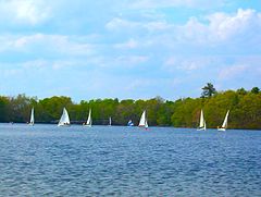
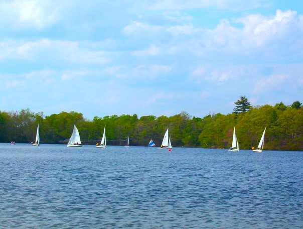
The Natick High School Sailing Team's fleet of boats on the pond. Location Natick, Massachusetts Coordinates 42°16′35″N 71°21′55″W / 42.27639°N 71.36528°W Primary outflows Streams to Charles River Basin countries United States Surface area 48 acres (19.42 ha) Average depth 15 ft (5 m) Max. depth 42 ft (13 m) Islands One Dug Pond is a small body of water in Natick, Massachusetts. Most notably it is home to Memorial Beach, one of few swimming beaches in Natick, and its eastern shore is the site of Natick High School.
 Aerial photograph of Dug Pond. The water at the top of the picture (north) is part of Lake Cochituate. At the south end of the pond, Memorial Beach is highlighted by a floating boundary rope. The island is at the top left of the pond, and Natick High School at the top right.
Contents
Uses
Memorial Beach is used in the summer for swimmers on day and season passes, boasting a picnic area, small playground, floating dock, and a separate platform with a diving board. A small building contains showers, bathrooms, and a changing area. The beach is also the start and finish of the swimming leg of the Natick Mini Triathlon. Swimming in the rest of the pond is not as common but is done by swimmers who are in need of larger areas.
The pond also has a recently renovated boat ramp located on the south side, suitable for canoes and car-top boats, which is used mainly for small fishing boats and also the fleet belonging to the Natick High School Sailing Team.
Fishing for pleasure (including ice fishing) is also relatively common, mainly on the northern shore where there are several fishing areas with dirt paths leading to Pond Street, and on the southern shore near the boat ramp. Rainbow Trout, Brown Trout, Brook Trout, largemouth bass, chain pickerels, bluegills, pumpkinseeds, brown bullheads,Carp, eels, perch, and golden shiners are all relatively common. A type of freshwater hydrozoan, Craspedacusta sowerbyi, can also be found in the pond.
The pond is also used by diving teams of the Natick Police and Fire Departments for practice rescue drills in both summer and winter, generally along the north shore.
Geography
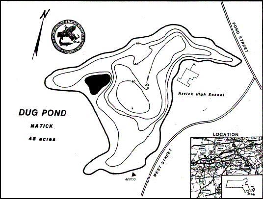
 MassWildlife's map of Dug Pond
Dug Pond is a typical New England pond, 48 acres (19.42 ha) in area, with depth reaching a maximum of 42 feet (13 m) and averaging 15 ft (5 m). The pond's transparency is relatively good and it has sparse aquatic vegetation. It has a sandbar near the center on which the depth is close to 3 feet (1 m), but for the most part the pond follows standard depth patterns. Generally, excluding the beach, the pond has steep dirt shores with trees growing close to the water. In winter, it is usually covered completely by ice and is often safe to walk on for months.
The pond has one significant wooded island, approximately 100,000 square feet (10,000 m2) in area near the western shore, accessible by wading in waist-deep water from trails on the channel at its south side. There is a rope swing on the island.
In the northeast corner of the pond is a small area of wetlands, where the stream that feeds the pond enters. (The stream leaves the pond near the boat ramp on the south side.)
The dip in Pond Street on Dug Pond's northern shore represents a significant split in water flow. All runoff to the north of Pond Street eventually runs (by way of Lake Cochituate) into the Sudbury River, which enters the Merrimack before reaching the Atlantic. All runoff south of Pond Street, including the outflow of Dug Pond itself, drains to the Charles River and eventually Boston Harbor.
Cultural significance
According to legend, the pond itself was excavated from level ground and intended to be used as a pasture for animals, but filled with rainwater, hence the name "Dug Pond." However, records held by the town show that the pond was present prior to any settlement in Natick, and it was the steep slope of the shores that led townspeople to guess it was a manmade pond.
One interesting cultural feature is a flat wall of concrete about five by twenty feet on the northwest shore, which is accessible by trails from above and by wading from below. This is the leftover foundation of an old icehouse. It is known to high school students simply as "The Wall," and because it is directly visible across the pond from many rooms of NHS, it is the site of constantly changing graffiti, mainly by members of high school sports teams.
By road, the distance around the pond is 1.86 miles, or almost exactly 3 km. Running this route starting at or near the high school is known as "running the pond," and is often a part of the tryouts for NHS sports teams, where the potential team members must finish the pond running, but generally not under any time limit.
Dug Pond is also the source of the name for the relatively significant road Pond Street, which runs parallel to Route 135 from downtown Natick to Speen Street.
References
- "MassWildlife - Pond Maps". http://www.mass.gov/dfwele/dfw/habitat/maps/ponds/pdf/dfwdugg.pdf. Retrieved September 18, 2007.
Categories:- Natick, Massachusetts
- Lakes of Middlesex County, Massachusetts
Wikimedia Foundation. 2010.