- Dalton, Massachusetts
-
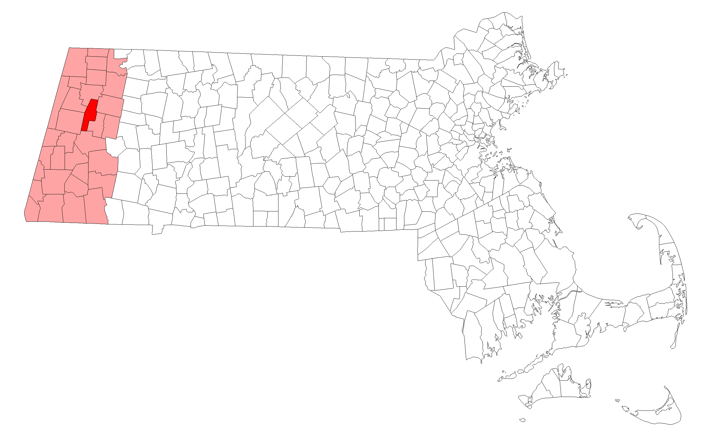
Dalton, Massachusetts — Town — Entering Dalton, Inc. 1784 Location in Berkshire County in Massachusetts
Coordinates: 42°28′25″N 73°10′00″W / 42.47361°N 73.1666667°WCoordinates: 42°28′25″N 73°10′00″W / 42.47361°N 73.1666667°W Country United States State Massachusetts County Berkshire Settled 1755 Incorporated 1784 Government – Type Open town meeting Area – Total 21.9 sq mi (56.6 km2) – Land 21.8 sq mi (56.5 km2) – Water 0.0 sq mi (0.1 km2) Elevation 1,199 ft (365 m) Population (2000) – Total 6,892 – Density 316.0/sq mi (122.0/km2) Time zone Eastern (UTC-5) – Summer (DST) Eastern (UTC-4) ZIP code 01226 Area code(s) 413 FIPS code 25-16180 GNIS feature ID 0619418 Website www.dalton-ma.gov Dalton is a town in Berkshire County, Massachusetts, United States. Dalton is the transition town between the urban and rural pieces of Berkshire County, Massachusetts. It is part of the Pittsfield, Massachusetts Metropolitan Statistical Area. The population was 6,892 at the 2000 census.
Contents
History
Dalton was first settled in 1755 and was officially incorporated in 1784. The town was named after Tristram Dalton, the Speaker of the Massachusetts House of Representatives at the time of the town's incorporation. Dalton was settled as a rural/industrial community, with mills set up along the East Branch of the Housatonic River, and small but good patches of farmland in areas away from it. In 1801, Zenas Crane, Henry Wiswall and John Willard set up a paper mill along the river which, by 1844, had begun producing bank note paper, which was purchased by banks all the way to Boston. The company, Crane & Co., still is the largest employer in town, making paper products, stationery, and, since 1873, has been the only supplier of paper for the Federal Reserve Note, the United States' paper money. The town now has a mix of small town and suburban qualities, having been served by trolleys to Pittsfield for many years.[1]
Geography
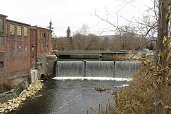

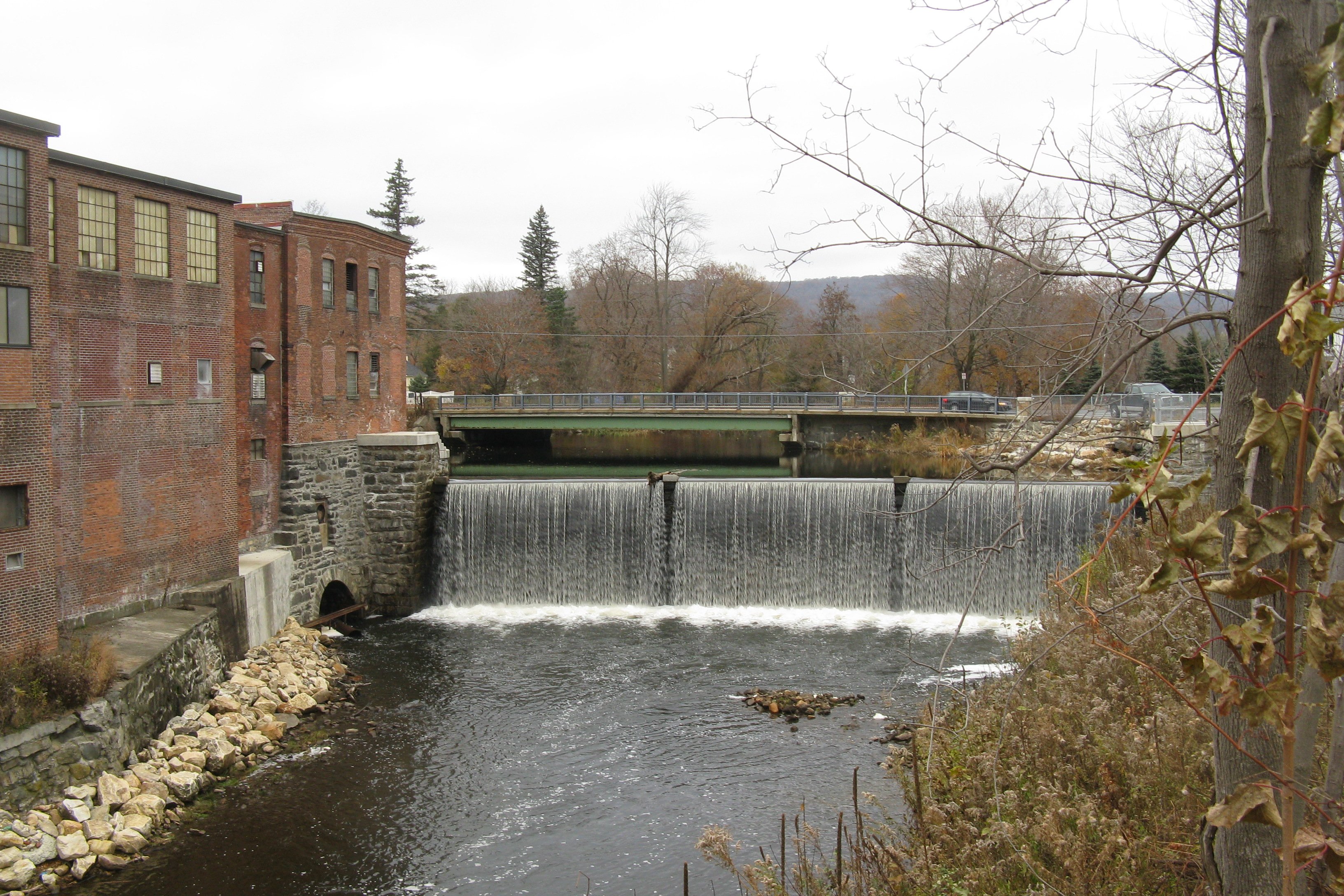
East branch of the Housatonic River
at Main Street and Depot StreetAccording to the United States Census Bureau, the town has a total area of 21.9 square miles (57 km2), of which 21.8 square miles (56 km2) is land and 0.04 square miles (0.10 km2) (0.18%) is water. Dalton is bordered by Cheshire to the northwest and north, Windsor to the northeast, Hinsdale to the east, Washington to the south, and Pittsfield and Lanesborough to the west. The town center is five miles northeast of downtown Pittsfield, 45 miles northwest of Springfield, and 140 miles west of Boston.
Dalton's center of population, due to its milling history, is around the valley of the East Branch of the Housatonic River. Several brooks run off of the river, including the Wahconah Falls Brook, whose eponymous waterfalls are a small state park. Much of the rest of town is dominated by the Berkshires, with the north being on a plain between the peaks of North and Western Mountains, covered by the Dalton Wildlife Management Area. The south is dominated by Tully Mountain, whose peak is just over the Hinsdale line. The Appalachian Trail winds through town, passing between Tully and North Mountains through the downtown area.
Dalton lies at the junction of Route 8, Route 8A and Route 9, with the latter two running concurrently. Route 9 is the major central east-west route through the state, and ends in neighboring Pittsfield. Dalton's nearest interstate is Interstate 90, also known as the Massachusetts Turnpike, whose nearest exit is 15 miles south of town. The town, formerly served by trolley service from Pittsfield, is still on a route of the Berkshire Regional Transit Authority's bus service. The rail line is still active in town, used by CSX Transportation. The nearest regional air service can be found at Pittsfield Municipal Airport, and the nearest national air service can be found at Albany International Airport.
Demographics
Historical populations Year Pop. ±% 1850 1,020 — 1860 1,243 +21.9% 1870 1,252 +0.7% 1880 2,052 +63.9% 1890 2,885 +40.6% 1900 3,014 +4.5% 1910 3,568 +18.4% 1920 3,752 +5.2% 1930 4,220 +12.5% 1940 4,206 −0.3% 1950 4,772 +13.5% 1960 6,436 +34.9% 1970 7,505 +16.6% 1980 6,797 −9.4% 1990 7,155 +5.3% 2000 6,892 −3.7% 2001* 6,801 −1.3% 2002* 6,775 −0.4% 2003* 6,740 −0.5% 2004* 6,697 −0.6% 2005* 6,647 −0.7% 2006* 6,621 −0.4% 2007* 6,605 −0.2% 2008* 6,577 −0.4% 2009* 6,550 −0.4% 2010 6,756 +3.1% * = population estimate.
Source: United States Census records and Population Estimates Program data.[2][3][4][5][6][7][8][9][10][11]As of the census[12] of 2000, there were 6,892 people, 2,712 households, and 1,857 families residing in the town. By population, Dalton ranks sixth out of the 32 cities and towns in Berkshire County, and 217th out of the 351 cities and towns in Massachusetts. The population density was 316.0 people per square mile (122.0/km²), which ranks 4th in the county and 210th in the Commonwealth. There were 2,832 housing units at an average density of 129.8 per square mile (50.1/km²). The racial makeup of the town was 97.78% White, 0.51% African American, 0.12% Native American, 0.71% Asian, 0.44% from other races, and 0.45% from two or more races. Hispanic or Latino of any race were 1.02% of the population.
There were 2,712 households out of which 32.2% had children under the age of 18 living with them, 54.5% were married couples living together, 10.9% had a female householder with no husband present, and 31.5% were non-families. 26.9% of all households were made up of individuals and 12.5% had someone living alone who was 65 years of age or older. The average household size was 2.50 and the average family size was 3.04.
In the town the population was spread out with 25.8% under the age of 18, 6.1% from 18 to 24, 26.2% from 25 to 44, 25.2% from 45 to 64, and 16.7% who were 65 years of age or older. The median age was 40 years. For every 100 females there were 91.5 males. For every 100 females age 18 and over, there were 85.5 males.
The median income for a household in the town was $47,891, and the median income for a family was $59,717. Males had a median income of $41,379 versus $28,885 for females. The per capita income for the town was $23,634. About 1.2% of families and 2.7% of the population were below the poverty line, including 1.5% of those under age 18 and 7.1% of those age 65 or over.
The town has churches for several different Christian denominations, including a Congregational church, a Roman Catholic Church, a Methodist Church, an Episcopal church and a Church of the Nazarene.
Government
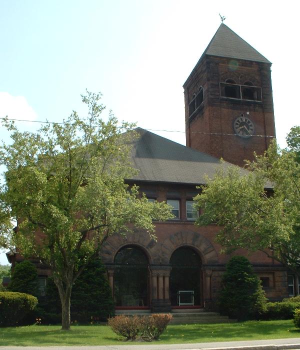
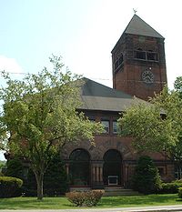 Dalton Town Hall
Dalton uses the open town meeting form of government, and is led by a board of selectmen and an administrative assistant. Dalton has its own police, fire (including ambulance squad) and public works departments. The town's public library, located adjacent to the town hall, is a member of the regional library network. The nearest hospital, Berkshire Medical Center, is in neighboring Pittsfield.
On the state level, Dalton is represented in the Massachusetts House of Representatives by the Second Berkshire district, which covers central Berkshire County, as well as portions of Hampshire and Franklin Counties. In the Massachusetts Senate, the town is represented by the Berkshire, Hampshire and Franklin district, which includes all of Berkshire County and western Hampshire and Franklin Counties.[13] The town is patrolled by the Fourth (Cheshire) Station of Barracks "B" of the Massachusetts State Police.[14]
On the national level, Dalton is represented in the United States House of Representatives as part of Massachusetts's 1st congressional district, and has been represented by John Olver of Amherst since June 1991. Massachusetts is currently represented in the United States Senate by senior Senator John Kerry and junior Senator Scott Brown.[15]
Education
Dalton is the town with the highest population in the Central Berkshire Regional School District. Craneville Elementary School serves Dalton students from kindergarten through fifth grade. Nessacus Regional Middle School, also in Dalton, serves all middle school students in the district, and Wahconah Regional High School is the district's high school, located in Dalton. The athletic teams are nicknamed the Warriors, and their colors are blue and white.
The town is also home to a parochial school, Saint Agnes, which serves students from pre-kindergarten through eighth grades. There are other private and parochial schools in neighboring Pittsfield, including a Catholic high school.
The nearest community college, Berkshire Community College, is located in Pittsfield. The nearest state college is Massachusetts College of Liberal Arts in North Adams, and the nearest university is the University of Massachusetts Amherst.
Dalton gave its name to the Dalton Plan educational concept and the Dalton School, see Helen Parkhurst.
Notable residents
- Dan Duquette, former general manager of the Boston Red Sox
- Jeff Reardon, baseball player
- Anton Strout, science fiction/fantasy writer
- Turk Wendell, baseball player
References
- ^ "Dalton, a historic settlement" from Dalton-MA.gov
- ^ "TOTAL POPULATION (P1), 2010 Census Summary File 1, All County Subdivisions within Massachusetts". United States Census Bureau. http://factfinder2.census.gov/bkmk/table/1.0/en/DEC/10_SF1/P1/0400000US25.06000. Retrieved September 13, 2011.
- ^ "Massachusetts by Place and County Subdivision - GCT-T1. Population Estimates". United States Census Bureau. http://factfinder.census.gov/servlet/GCTTable?_bm=y&-geo_id=04000US25&-_box_head_nbr=GCT-T1&-ds_name=PEP_2009_EST&-_lang=en&-format=ST-9&-_sse=on. Retrieved July 12, 2011.
- ^ "1990 Census of Population, General Population Characteristics: Massachusetts". US Census Bureau. December 1990. Table 76: General Characteristics of Persons, Households, and Families: 1990. 1990 CP-1-23. http://www.census.gov/prod/cen1990/cp1/cp-1-23.pdf. Retrieved July 12, 2011.
- ^ "1980 Census of the Population, Number of Inhabitants: Massachusetts". US Census Bureau. December 1981. Table 4. Populations of County Subdivisions: 1960 to 1980. PC80-1-A23. http://www2.census.gov/prod2/decennial/documents/1980a_maABC-01.pdf. Retrieved July 12, 2011.
- ^ "1950 Census of Population". Bureau of the Census. 1952. Section 6, Pages 21-10 and 21-11, Massachusetts Table 6. Population of Counties by Minor Civil Divisions: 1930 to 1950. http://www2.census.gov/prod2/decennial/documents/23761117v1ch06.pdf. Retrieved July 12, 2011.
- ^ "1920 Census of Population". Bureau of the Census. Number of Inhabitants, by Counties and Minor Civil Divisions. Pages 21-5 through 21-7. Massachusetts Table 2. Population of Counties by Minor Civil Divisions: 1920, 1910, and 1920. http://www2.census.gov/prod2/decennial/documents/41084506no553ch2.pdf. Retrieved July 12, 2011.
- ^ "1890 Census of the Population". Department of the Interior, Census Office. Pages 179 through 182. Massachusetts Table 5. Population of States and Territories by Minor Civil Divisions: 1880 and 1890. http://www2.census.gov/prod2/decennial/documents/41084506no553ch2.pdf. Retrieved July 12, 2011.
- ^ "1870 Census of the Population". Department of the Interior, Census Office. 1872. Pages 217 through 220. Table IX. Population of Minor Civil Divisions, &c. Massachusetts. http://www2.census.gov/prod2/decennial/documents/1870e-05.pdf. Retrieved July 12, 2011.
- ^ "1860 Census". Department of the Interior, Census Office. 1864. Pages 220 through 226. State of Massachusetts Table No. 3. Populations of Cities, Towns, &c.. http://www2.census.gov/prod2/decennial/documents/1860a-08.pdf. Retrieved July 12, 2011.
- ^ "1850 Census". Department of the Interior, Census Office. 1854. Pages 338 through 393. Populations of Cities, Towns, &c.. http://www2.census.gov/prod2/decennial/documents/1850c-11.pdf. Retrieved July 12, 2011.
- ^ "American FactFinder". United States Census Bureau. http://factfinder.census.gov. Retrieved 2008-01-31.
- ^ Senators and Representatives by City and Town
- ^ Station B-4, SP Cheshire
- ^ Viser, Matt; Phillips, Frank; Ryan, Andrew (2009-09-24). "Kirk to be interim senator". The Boston Globe. http://www.boston.com/news/local/breaking_news/2009/09/kirk_to_be_name.html.
External links
Municipalities and communities of Berkshire County, Massachusetts Cities 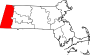
Towns Adams | Alford | Becket | Cheshire | Clarksburg | Dalton | Egremont | Florida | Great Barrington | Hancock | Hinsdale | Lanesborough | Lee | Lenox | Monterey | Mount Washington | New Ashford | New Marlborough | Otis | Peru | Richmond | Sandisfield | Savoy | Sheffield | Stockbridge | Tyringham | Washington | West Stockbridge | Williamstown | Windsor
CDPs Adams | Great Barrington | Housatonic | Lee | Lenox | Williamstown
Other
villagesCategories:- Towns in Berkshire County, Massachusetts
- Populated places established in 1755


Wikimedia Foundation. 2010.