- Hinsdale, Massachusetts
Infobox Settlement
official_name = Hinsdale, Massachusetts
nickname =
motto =
imagesize =
image_caption = Ashmere Lake from Rte. 143, looking north.
image_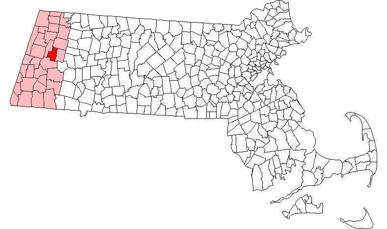
mapsize = 250px
map_caption = Location in Berkshire County in Massachusetts
mapsize1 =
map_caption1 =
subdivision_type = Country
subdivision_name =United States
subdivision_type1 = State
subdivision_name1 =Massachusetts
subdivision_type2 = County
subdivision_name2 = Berkshire
established_title = Settled
established_date = 1763
established_title2 = Incorporated
established_date2 = 1804
established_title3 =
established_date3 =
government_type =Open town meeting
leader_title =
leader_name =
leader_title1 =
leader_name1 =
area_magnitude =
area_total_km2 = 56.2
area_total_sq_mi = 21.7
area_land_km2 = 54.0
area_land_sq_mi = 20.8
area_water_km2 = 2.2
area_water_sq_mi = 0.9
population_as_of = 2000
settlement_type = Town
population_total = 1872
population_density_km2 = 34.7
population_density_sq_mi = 89.8
elevation_m = 440
elevation_ft = 1442
timezone = Eastern
utc_offset = -5
timezone_DST = Eastern
utc_offset_DST = -4
latd = 42 |latm = 26 |lats = 19 |latNS = N
longd = 73 |longm = 07 |longs = 33 |longEW = W
website =
postal_code_type = ZIP code
postal_code = 01235
area_code = 413
blank_name = FIPS code
blank_info = 25-30315
blank1_name = GNIS feature ID
blank1_info = 0618266
footnotes =Hinsdale is a town in Berkshire County,
Massachusetts ,United States . It is part of the Pittsfield,Massachusetts Metropolitan Statistical Area . The population was 1,872 at the 2000 census.History
Originally part of Northern Berkshire Township Number 2 and including all of Peru and part of Middlefield, the town was first settled in 1763 and was officially incorporated as part of Partridgefield in 1771. Originally named for Oliver Partridge, one of the three purchasers of the town (along with Governor
Francis Bernard ), the Western Parish officially broke away from its eastern half and incorporated in 1804, renaming itself for one of the earliest families in town, the Hinsdales, who also owned an important wool mill. The mill was the center of economic activity in town until theGreat Depression , when it closed. Today, the town is mostly rural, surviving mostly as a distant suburb of Pittsfield.Geography
According to the
United States Census Bureau , the town has a total area of 21.7square mile s (56.2km² ), of which, 20.8 square miles (54.0 km²) of it is land and 0.9 square miles (2.2 km²) of it (3.96%) is water. Hinsdale is located in central Berkshire County, and is bordered by Windsor to the north, Peru to the east, Washington to the south, and Dalton to the west. Hinsdale is 9 miles east of Pittsfield, 42 miles northwest of Springfield, and 120 miles west of Boston.Hinsdale is located in the Berkshire Hills, with most of its population located in a valley along the East Branch of the
Housatonic River , whose origin is just south of the town line. Much of the land around the river south of the town center is part of the Hinsdale Flats Wildlife Management Reserve, and is generally a swampy area. There are four reservoirs within the town (Belmont, Plunkett, Cleveland Brook and a portion of the Windsor Reservoir), as well as part of Muddy Pond in the south and most of Ashmere Lake along the Peru town line. The town, which contains the peak of Tully Mountain along the western border, also is traversed by a portion of theAppalachian Trail , which crosses the mountain. The town also has several summer camps, and a country club.Route 8 Crosses the town from the south to the Dalton border in the northwest. Route 143 also begins at Route 8 at the center of town. The town lies along a
CSX Transportation rail line, which brings Amtrak and freight service to Pittsfield. The town also lies at the eastern terminus of the [http://www.berkshirerta.com Berkshire Regional Trainsit Authority] bus line. Regional bus service can be found in Pittsfield, which is also home to the nearest regional air service (atPittsfield Municipal Airport ). The nearest airport with national flights isBradley International Airport in Connecticut.Demographics
As of the
census GR|2 of 2000, there were 1,872 people, 739 households, and 509 families residing in the town. By population, the town ranks 13th of the 32 cities and towns in Berkshire County, and 292nd of 351 cities and towns in Massachusetts. Thepopulation density was 89.8 people per square mile (34.7/km²), which ranks 13th and 290th in the county and Commonwealth, respectively. There were 970 housing units at an average density of 46.6/sq mi (18.0/km²). The racial makeup of the town was 97.81% White, 0.53% African American, 0.27% Asian, and 1.39% from two or more races. Hispanic or Latino of any race were 0.32% of the population.There were 739 households out of which 31.5% had children under the age of 18 living with them, 54.1% were married couples living together, 9.2% had a female householder with no husband present, and 31.0% were non-families. 25.7% of all households were made up of individuals and 7.3% had someone living alone who was 65 years of age or older. The average household size was 2.53 and the average family size was 3.04.
In the town the population was spread out with 25.6% under the age of 18, 7.4% from 18 to 24, 29.8% from 25 to 44, 25.9% from 45 to 64, and 11.3% who were 65 years of age or older. The median age was 38 years. For every 100 females there were 103.0 males. For every 100 females age 18 and over, there were 99.1 males.
The median income for a household in the town was $42,500, and the median income for a family was $51,118. Males had a median income of $38,333 versus $24,420 for females. The
per capita income for the town was $19,797. About 6.4% of families and 8.2% of the population were below thepoverty line , including 11.5% of those under age 18 and 8.2% of those age 65 or over.Government
Hinsdale employs the
open town meeting form of government, and is led by aboard of selectmen . The town has its own services, including police, fire and public works departments. Hinsdale shares its post office (and itsZIP code of 01235) with neighboring Peru. The nearest hospital, the Berkshire Medical Center, is located in Pittsfield.On the state level, Hinsdale is represented in the
Massachusetts House of Representatives by the Second Berkshire district, which covers central Berkshire County, as well as portions of Hampshire and Franklin Counties. In theMassachusetts Senate , the town is represented by the Berkshire, Hampshire and Franklin district, which includes all of Berkshire County and western Hampshire and Franklin Counties. [ [http://www.mass.gov/legis/citytown.htm Senators and Representatives by City and Town] ] The town is patrolled by the Fourth (Cheshire) Station of Barracks "B" of theMassachusetts State Police . [ [http://www.mass.gov/?pageID=eopsterminal&L=5&L0=Home&L1=Law+Enforcement+%26+Criminal+Justice&L2=Law+Enforcement&L3=State+Police+Troops&L4=Troop+B&sid=Eeops&b=terminalcontent&f=msp_divisions_field_services_troops_troop_b_msp_field_troop_b_station_b4&csid=Eeops Station B-4, SP Cheshire] ]On the national level, Hinsdale is represented in the
United States House of Representatives as part ofMassachusetts's 1st congressional district , and has been represented byJohn Olver of Amherst since June 1991. Massachusetts is represented in theUnited States Senate by senior SenatorTed Kennedy and junior SenatorJohn Kerry .Education
Hinsdale is one of the seven towns in the
Central Berkshire Regional School District , the largest district (by land area) in the Commonwealth. Students in Hinsdale attend the Kittredge Elementary School in the town for elementary school, along with students from Peru. All students in the district travel to Dalton to attend Nessacus Regional Middle School for sixth through eighth grades and Wahconah Regional High School for the high grades. There are no private schools in Hinsdale, with the nearest being in the Pittsfield area.The nearest community college is
Berkshire Community College in Pittsfield. The nearest state college isMassachusetts College of Liberal Arts in North Adams, and the nearest state university is theUniversity of Massachusetts Amherst .Points of interest
*
Camp Taconic
*Camp Romaca
*Camp Emerson
*Plunkett Lake
*Israel Bissell Homestead and Grave
*Lake Ashmere
*Camp Ashmere
* [http://www.hinsdalelibrary.org The Hinsdale Public Library]
*Town Hall http://hinsdale-mass.org/code/html/index.php
* [http://www.hinsdale200.org Hinsdale Dayz Inc.]
*Dan Duquette Sports AcademyReferences
Wikimedia Foundation. 2010.