- Montezuma County, Colorado
-
Montezuma County, Colorado 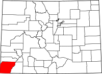
Location in the state of Colorado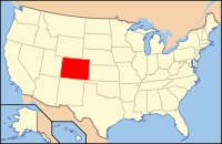
Colorado's location in the U.S.Founded April 16, 1889 Named for Aztec ruler Montezuma[disambiguation needed  ]
]Seat Cortez Largest city Cortez Area
- Total
- Land
- Water
2,039.97 sq mi (5,283 km²)
2,036.63 sq mi (5,275 km²)
3.34 sq mi (9 km²), 0.16%Population
- (2000)
- Density
23,830
12/sq mi (5/km²)Time zone Mountain: UTC-7/-6 Website www.co.montezuma.co.us Footnotes: 20th most populous Colorado county Montezuma County is the southwesternmost of the 64 counties of the state of Colorado of the United States. The county population was 23,830 at U.S. Census 2000.[1] The county seat is Cortez.
Mesa Verde National Park, Canyons of the Ancients National Monument, Yucca House National Monument, and Hovenweep National Monument preserve hundreds of ancient AmerIndian structures, including the famous cliff-dwellings, found in the county. Montezuma County is also home to most of the Ute Mountain Indian Reservation, home of the Weeminuche Band of the Ute Nation, known as the Ute Mountain Ute Tribe, with its headquarters at Towaoc.
Contents
History
Montezuma County has been settled since approximately AD 600, and had an estimated population of approximately 100,000, four times its current population, in the 12th century. However, a series of events caused virtually all permanent settlements to be abandoned between 1200 and 1300, and the area was contested between nomadic Ute and Navajo bands until resettlement occurred in the 1870s. Montezuma County was created out of the western portion of La Plata County by the Colorado Legislature in April, 1889. It was named in honor of a famous chief of the Aztec Indians in Mexico, Moctezuma II. The building ruins in Mesa Verde National Park were thought to be of Aztec origin at the time.
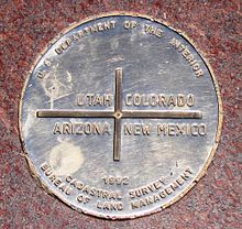 Montezuma County includes the Colorado section of the Four Corners Monument.
Geography
According to the 2000 census, the county has a total area of 2,039.97 square miles (5,283.5 km2), of which 2,036.63 square miles (5,274.8 km2) (or 99.84%) is land and 3.34 square miles (8.7 km2) (or 0.16%) is water.[2]
Today, there are three incorporated municipalities in Montezuma County: Cortez, Dolores, and Mancos, and a large number of unincorporated communities, including Towaoc, Lewis, Arriola, Mesa Verde, Lebanon, Stoner, Weber, and Battle Rock.
A large county, roughly 1/3 is tribal land, 1/3 is federal land (administered by the National Park Service, the United States Forest Service and the Bureau of Land Management), and 1/3 private or state/county land. It is also varied topographically, ranging in elevation from about 6000 feet to more than 14,000 feet, and from high Colorado Plateau Desert to Alpine Tundra, and has the second largest reservoir in Colorado, McPhee Reservoir, many other large reservoirs, and hundreds of private lakes and ponds. Much of the county is irrigated cropland, and it produces fruit, large numbers of cattle and sheep, and beans. It is served by US Highways 160 and 491 (formerly the infamous US Highway 666), and by a Municipal Airport at Cortez. It has no rail service, although both Mancos and Dolores were established as railroad towns in the 1890s.
Adjacent counties
- Dolores County, Colorado - north
- San Juan County, Colorado - northeast
- La Plata County, Colorado - east
- San Juan County, New Mexico - south
- Apache County, Arizona - southwest
- San Juan County, Utah - west
Montezuma County is the only county in the United States to border three counties with the same name in three different states (San Juan County in Colorado, New Mexico, and Utah). The "border" with San Juan County, Colorado, is, however, only a point of zero length.
Demographics
As of the census[3] of 2000, there were 23,830 people, 9,201 households, and 6,514 families residing in the county. The population density was 12 people per square mile (5/km²). There were 10,497 housing units at an average density of 5 per square mile (2/km²). The racial makeup of the county was 81.72% White, 0.14% Black or African American, 11.23% Native American, 0.20% Asian, 0.06% Pacific Islander, 4.26% from other races, and 2.38% from two or more races. 9.50% of the population were Hispanic or Latino of any race.
There were 9,201 households out of which 33.30% had children under the age of 18 living with them, 56.40% were married couples living together, 10.60% had a female householder with no husband present, and 29.20% were non-families. 24.60% of all households were made up of individuals and 9.30% had someone living alone who was 65 years of age or older. The average household size was 2.54 and the average family size was 3.04.
In the county the population was spread out with 27.50% under the age of 18, 7.10% from 18 to 24, 26.30% from 25 to 44, 25.30% from 45 to 64, and 13.80% who were 65 years of age or older. The median age was 38 years. For every 100 females there were 96.70 males. For every 100 females age 18 and over, there were 92.20 males.
The median income for a household in the county was $32,083, and the median income for a family was $38,071. Males had a median income of $30,666 versus $21,181 for females. The per capita income for the county was $17,003. About 13.10% of families and 16.40% of the population were below the poverty line, including 23.20% of those under age 18 and 14.40% of those age 65 or over.
Cities and towns
National parks
- Canyons of the Ancients National Monument (part) - administered by Bureau of Land Management
- Hovenweep National Monument (part)
- Mesa Verde National Park and UNESCO World Heritage Site
- Yucca House National Monument
Other protected areas
- Lowry Ruin National Historic Landmark now part of Canyons of the Ancients National Monument
- Mancos State Park
- Mesa Verde Wilderness
- San Juan National Forest
- McPhee Reservoir
National trails
- Calico National Recreation Trail
- Highline Loop National Recreation Trail
- Old Spanish National Historic Trail
- Petroglyph Point National Recreation Trail
National scenic byways
- San Juan Skyway National Scenic Byway
- Trail of the Ancients National Scenic and Historic Byway
Bicycle routes
See also
- Colorado census statistical areas
- Colorado counties
- Colorado municipalities
- William B. Ebbert, represented Montezuma in the Colorado General Assembly in early 20th century.
- National Register of Historic Places listings in Montezuma County, Colorado
References
- ^ "Annual County Population Estimates and Estimated Components of Change: April 1, 2000 to July 1, 2006 (CO-EST2006-alldata)" (CSV). 2006 Population Estimates. United States Census Bureau, Population Division. 2007-03-22. http://www.census.gov/popest/counties/files/CO-EST2006-ALLDATA.csv. Retrieved 2007-05-10.
- ^ "Census 2000 U.S. Gazetteer Files: Counties". United States Census. http://www.census.gov/tiger/tms/gazetteer/county2k.txt. Retrieved 2011-02-13.
- ^ "American FactFinder". United States Census Bureau. http://factfinder.census.gov. Retrieved 2008-01-31.
External links
- Montezuma County Government website
- Montezuma County Sheriff's Office
- Canyons of the Ancients National Monument website
- Hovenweep National Monument website
- Mesa Verde National Park website
- Yucca House National Monument website
- Colorado County Evolution by Don Stanwyck
- Colorado Historical Society

Dolores County San Juan County San Juan County, Utah 
La Plata County  Montezuma County, Colorado

Apache County, Arizona San Juan County, New Mexico Municipalities and communities of Montezuma County, Colorado City 
Towns CDP Unincorporated
communitiesIndian
reservationCategories:- Colorado counties
- Montezuma County, Colorado
- 1889 establishments


Wikimedia Foundation. 2010.