- Mesa County, Colorado
-
Mesa County, Colorado 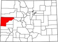
Location in the state of Colorado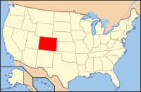
Colorado's location in the U.S.Founded February 14, 1883 Named for mesas in the area Seat Grand Junction Largest city Grand Junction Area
- Total
- Land
- Water
3,341.11 sq mi (8,653 km²)
3,327.75 sq mi (8,619 km²)
13.36 sq mi (35 km²), 0.40%Population
- (2000)
- Density
116,255
34/sq mi (13/km²)Time zone Mountain: UTC-7/-6 Website www.mesacounty.us Footnotes: Eleventh most populous Colorado county Mesa County is the fourth most extensive and the eleventh most populous of the 64 counties of the State of Colorado in the United States. The county was named for the many large mesas in the area, including Grand Mesa. The county population was 116,255 at U.S. Census 2000.[1] The county seat is Grand Junction. The Grand Junction Metropolitan Statistical Area comprises Mesa County.
Contents
Geography
According to the 2000 census, the county has a total area of 3,341.11 square miles (8,653.4 km2), of which 3,327.75 square miles (8,618.8 km2) (or 99.60%) is land and 13.36 square miles (34.6 km2) (or 0.40%) is water.[2]
Adjacent counties
- Garfield County, Colorado - north
- Pitkin County, Colorado - east
- Gunnison County, Colorado - east
- Delta County, Colorado - southeast
- Montrose County, Colorado - south
- Grand County, Utah - west
Demographics
{{USCensusPop | 1890=4260 | 1900=9267 | 1910=22197 | 1920=22281 | 1930=25908 | 1940=33791 | 1950=38794 | 1960=50715 | 1970=54734 | 1980=81530 | 1990=93145 | 2000=116255 | 2010=146723]]
As of the census[3] of 2000, there were 116,255 people, 45,823 households, and 31,572 families residing in the county. The population density was 35 people per square mile (13/km²). There were 48,427 housing units at an average density of 15 per square mile (6/km²). The racial makeup of the county was 92.34% White, 0.46% Black or African American, 0.91% Native American, 0.53% Asian, 0.10% Pacific Islander, 3.67% from other races, and 1.99% from two or more races. 10.02% of the population were Hispanic or Latino of any race.
There were 45,823 households out of which 31.40% had children under the age of 18 living with them, 55.30% were married couples living together, 9.80% had a female householder with no husband present, and 31.10% were non-families. 25.10% of all households were made up of individuals and 10.30% had someone living alone who was 65 years of age or older. The average household size was 2.47 and the average family size was 2.94.
In the county the population was spread out with 25.00% under the age of 18, 9.40% from 18 to 24, 26.70% from 25 to 44, 23.70% from 45 to 64, and 15.20% who were 65 years of age or older. The median age was 38 years. For every 100 females there were 96.00 males. For every 100 females age 18 and over, there were 93.20 males.
The median income for a household in the county was $35,864, and the median income for a family was $43,009. Males had a median income of $32,316 versus $22,374 for females. The per capita income for the county was $18,715. About 7.00% of families and 10.20% of the population were below the poverty line, including 11.50% of those under age 18 and 8.10% of those age 65 or over.
Cities and towns
- Carpenter
- Clifton
- Collbran
- De Beque
- Fruita
- Fruitvale
- Gateway
- Grand Junction
- Loma
- Mack
- Mesa
- Molina
- Orchard Mesa
- Palisade
- Plateau City
- Redlands
- Whitewater
National park
National conservation area
National forests and wilderness
- Grand Mesa National Forest
- Uncompahgre National Forest
- White River National Forest
- Black Ridge Canyons Wilderness
- Dominguez Canyon Wilderness
State parks
- Highline Lake State Park
- James M. Robb – Colorado River State Park
- Vega State Park
Trails
- American Discovery Trail
- Kokopelli Trail
- Old Spanish National Historic Trail
Scenic byways
- Dinosaur Diamond Prehistoric Highway National Scenic Byway
- Grand Mesa National Scenic and Historic Byway
- Unaweep/Tabeguache Scenic and Historic Byway
See also
- Colorado census statistical areas
- Colorado counties
- Colorado metropolitan areas
- Colorado municipalities
- Grand Junction Metropolitan Statistical Area
- National Register of Historic Places listings in Mesa County, Colorado
References
- ^ "Annual County Population Estimates and Estimated Components of Change: April 1, 2000 to July 1, 2006 (CO-EST2006-alldata)" (CSV). 2006 Population Estimates. United States Census Bureau, Population Division. 2007-03-22. http://www.census.gov/popest/counties/files/CO-EST2006-ALLDATA.csv. Retrieved 2007-05-10.
- ^ "Census 2000 U.S. Gazetteer Files: Counties". United States Census. http://www.census.gov/tiger/tms/gazetteer/county2k.txt. Retrieved 2011-02-13.
- ^ "American FactFinder". United States Census Bureau. http://factfinder.census.gov. Retrieved 2008-01-31.
External links
- Mesa County Government website
- Colorado County Evolution by Don Stanwyck
- Colorado Historical Society

Garfield County Grand County, Utah 
Pitkin County and Gunnison County  Mesa County, Colorado

Montrose County Delta County Municipalities and communities of Mesa County, Colorado Cities 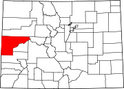
Towns CDPs Clifton | Fruitvale | Orchard Mesa | Redlands
Unincorporated
communitiesGateway | Glade Park | Loma | Mack | Mesa | Molina | Whitewater
Ghost town Categories:- Colorado counties
- Mesa County, Colorado
- 1883 establishments in the United States
- Populated places established in 1883


Wikimedia Foundation. 2010.