- Collbran, Colorado
-
Town of Collbran, Colorado — Town — Main Street in downtown Collbran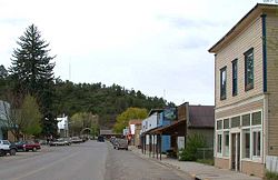 Location in Mesa County and the State of Colorado
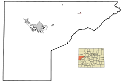
Coordinates: 39°14′21″N 107°57′58″W / 39.23917°N 107.96611°WCoordinates: 39°14′21″N 107°57′58″W / 39.23917°N 107.96611°W Country  United States
State  State of Colorado
County[1] Mesa County Incorporated July 22, 1908[2] Government – Type Statutory Town[1] Area – Total 0.5 sq mi (1.3 km2) – Land 0.5 sq mi (1.3 km2) – Water 0 sq mi (0 km2) Elevation[3] 5,984 ft (1,824 m) Population (2000) – Total 388 – Density 776/sq mi (298.5/km2) Time zone MST (UTC-7) – Summer (DST) MDT (UTC-6) ZIP Code[4] 81624 Area code(s) 970 FIPS code 08-15605 GNIS feature ID 0204663 Collbran is a Statutory Town in Mesa County, Colorado, United States. It is part of the Grand Junction Metropolitan Statistical Area. The population was 388 at the 2000 census. The town is located east of Grand Junction along Plateau Creek, at the upper (eastern) end of the small cattle ranching valley around the creek known as the Plateau Valley. The largest community in the valley, it serves a civic and economic center for the surrounding area, which is dependent not only ranching, but on pass-through tourism during the summer and autumn months. In the latter capacity, the town acts somewhat as a gateway to nearby Vega State Park and other recreational sites along the northeast side of the Grand Mesa via the Grand Mesa Scenic and Historic Byway.
Contents
Geography
Collbran is located at 39°14′21″N 107°57′58″W / 39.23917°N 107.96611°W (39.239217, -107.966230)[5].
According to the United States Census Bureau, the town has a total area of 0.5 square miles (1.3 km2), all of it land.
Demographics
As of the census[6] of 2000, there were 388 people, 145 households, and 100 families residing in the town. The population density was 777.1 people per square mile (299.6/km²). There were 161 housing units at an average density of 322.5 per square mile (124.3/km²). The racial makeup of the town was 98.20% White, 0.26% Native American, 0.77% from other races, and 0.77% from two or more races. Hispanic or Latino of any race were 4.12% of the population.
There were 145 households out of which 36.6% had children under the age of 18 living with them, 53.8% were married couples living together, 9.7% had a female householder with no husband present, and 31.0% were non-families. 27.6% of all households were made up of individuals and 12.4% had someone living alone who was 65 years of age or older. The average household size was 2.50 and the average family size was 3.03.
 Main Street in downtown Collbran
In the town the population was spread out with 29.6% under the age of 18, 3.6% from 18 to 24, 26.8% from 25 to 44, 23.5% from 45 to 64, and 16.5% who were 65 years of age or older. The median age was 38 years. For every 100 females there were 87.4 males. For every 100 females age 18 and over, there were 84.5 males.
The median income for a household in the town was $32,500, and the median income for a family was $36,016. Males had a median income of $28,438 versus $27,917 for females. The per capita income for the town was $17,080. About 5.9% of families and 14.7% of the population were below the poverty line, including 17.2% of those under age 18 and 8.0% of those age 65 or over.
See also
References
- ^ a b "Active Colorado Municipalities". State of Colorado, Department of Local Affairs. http://www.dola.state.co.us/dlg/local_governments/municipalities.html. Retrieved 2007-09-01.
- ^ "Colorado Municipal Incorporations". State of Colorado, Department of Personnel & Administration, Colorado State Archives. 2004-12-01. http://www.colorado.gov/dpa/doit/archives/muninc.html. Retrieved 2007-09-02.
- ^ "US Board on Geographic Names". United States Geological Survey. 2007-10-25. http://geonames.usgs.gov. Retrieved 2008-01-31.
- ^ "ZIP Code Lookup" (JavaScript/HTML). United States Postal Service. http://zip4.usps.com/zip4/citytown.jsp. Retrieved September 5, 2007.
- ^ "US Gazetteer files: 2010, 2000, and 1990". United States Census Bureau. 2011-02-12. http://www.census.gov/geo/www/gazetteer/gazette.html. Retrieved 2011-04-23.
- ^ "American FactFinder". United States Census Bureau. http://factfinder.census.gov. Retrieved 2008-01-31.
External links
- Town of Collbran contacts
- CDOT map of the Town of Collbran
- http://www.publicschoolreview.com/school_ov/school_id/13989
Municipalities and communities of Mesa County, Colorado Cities 
Towns CDPs Clifton | Fruitvale | Orchard Mesa | Redlands
Unincorporated
communitiesGateway | Glade Park | Loma | Mack | Mesa | Molina | Whitewater
Ghost town Categories:- Populated places in Mesa County, Colorado
- Towns in Colorado


Wikimedia Foundation. 2010.