- Fruita, Colorado
-
- "Fruita" redirects here. For the ghost town in Utah, see Fruita, Utah. For the Coca-Cola brand, see List of Coca-Cola brands
City of Fruita, Colorado — City — [[File: |250 pxl|none|alt=|]] Interstate 70 sign at Fruita exit
Nickname(s): Home of Mike the Headless Chicken Motto: Honor the Past, Envision the Future Location in Mesa County and the state of Colorado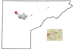
Coordinates: 39°9′N 108°43′W / 39.15°N 108.717°WCoordinates: 39°9′N 108°43′W / 39.15°N 108.717°W Country  United States
State  Colorado
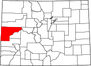
County[1] Mesa County Established 1884 Incorporated April 18, 1894[2] Government – Type Home Rule Municipality[1] – Mayor Ken Henry[3] Area – Total 6 sq mi (15.6 km2) – Land 5.9 sq mi (15.4 km2) – Water 0.1 sq mi (0.2 km2) Elevation[4] 4,514 ft (1,376 m) Population (2008) – Total 11,535 Time zone MST (UTC-7) – Summer (DST) MDT (UTC-6) ZIP code[5] 81521 Area code(s) 970 FIPS code 08-28745 GNIS feature ID 0204660 Website City of Fruita The City of Fruita (pronounced /ˈfruːtə/) is a Home Rule Municipality located in the western part of Mesa County, Colorado, United States. It is part of the Grand Junction Metropolitan Statistical Area and within the Grand Valley. The geography is identified by the bordering Colorado River (historically known as the Grand River) on the southern edge of town, the Uncompahgre Plateau known for its pinyon-juniper landscape, and the Book Cliffs range on the northern edge of the Grand Valley. It is located 18 miles (29 km) east of the Utah border near the 39° parallel. The population was 11,535 at the 2008 census. Originally home to the Ute people, white farmers settled the town after founder William Pabor in 1884. Ten years later, Fruita was incorporated.
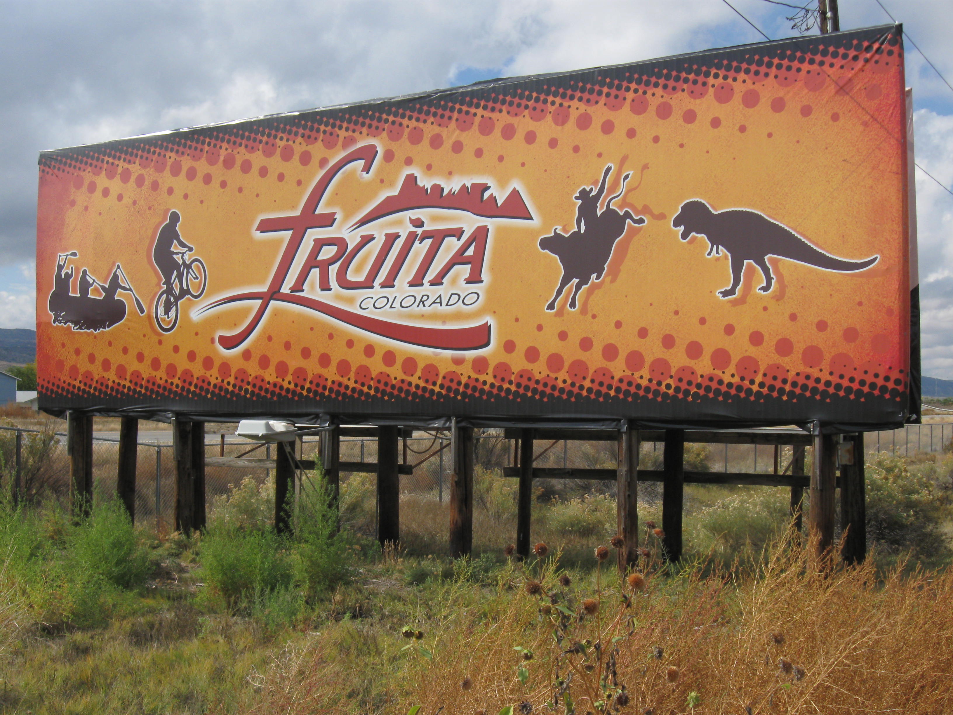
Economically, it started out as a fruit producing region, however today it is well known for its outdoor sports such as mountain biking, hiking, and rafting, its proximity to the Colorado National Monument, and its annual festivals. Fruita has been the winner of the Governor’s Smart Growth and Development Award for four consecutive years. The city motto is "Honor the Past, Envision the Future".
Contents
History
Fruita has had steady population growth for over a century, with descendants of many of the original pioneers still living in the area. The first permanent homesteaders in the Fruita area were possibly Mr. and Mrs. Albert Lapham who settled in late 1882. They resided in a pre-existing cabin with a dirt floor and a blanket door. They were followed by other settlers, nearly all of whom were farmers of one sort or another. The present day town was established on May 1, 1884 by William E. Pabor, when he formed the Fruita Town and Land Company. In 1886, for the cost of $500 a farmer could buy five acres, 200 fruit trees and water. Pabor recognized the great promise of the Grand Valley and penned a 300-page volume, “ Colorado as an Agricultural State ,” in which he spoke of the fruit growing potential of this area. Having worked with the Horace Greeley Union Colony, he founded the town in a similar way, including the provision that no liquor was sold or manufactured in the town. This provision lasted until it was voted out in the late 1970s.
The original town site was planned for eighty acres with a park in the middle. The first water reached the town from the Colorado River in 1907. By 1909, the town center was linked with electricity. In the 1930s, Fruita participated in several government projects including the Grand Valley Resettlement Project (later Western Slope Farms). Settled in groups of two or three families per area, thirty-four families were relocated by 1937. Later, the Rural Electrification Project brought electricity to around 800 to 900 farms. Fruita also had a Civilian Conservation Corps, several Works Progress Administration projects including the town library (now the Chamber of Commerce), a federal loan for the new central school (now the Civic Center) and the construction of the spectacular Rim Rock Drive to the top of the Colorado National Monument, elevation 8,000 feet.[6] Today, the historic activities of Fruita are supported by the efforts of the Fruita Historic Preservation Board and the Lower Valley Heritage Chapter.
Paleontology
 Dinosaur Hill
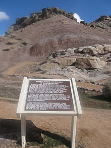
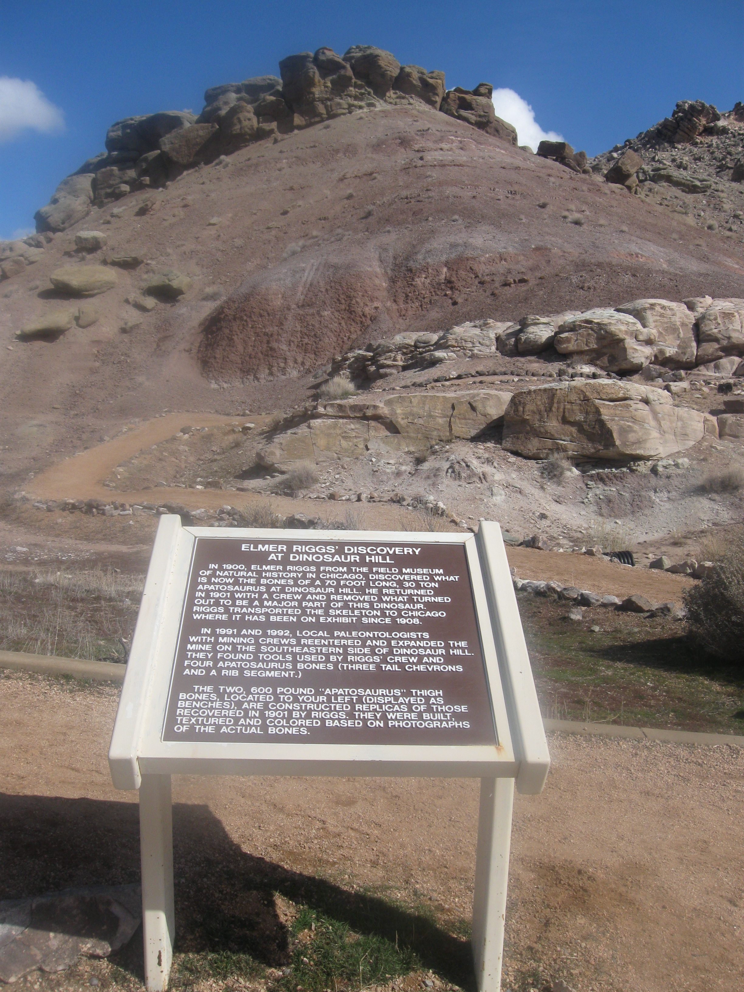
In 1900, palentologist Elmer Riggs and crew, from the Field Museum of Natural History in Chicago, found the first known Brachiosaurus altithorax at Dinosaur Hill located off State Highway 340in Fruita. Led here by communications with Dr. S.M. Bradbury of Grand Junction, Riggs had heard that ranchers had been collecting fossils around the area for 20 years. In 1901, Riggs and crew found nearly two thirds of a specimen of Apatosaurus excelsus skeleton (commonly known as a Brontosaurus) on the northeast side of the hill. This is still considered to be one of the finest specimens known. Later, Diplodocus bones were also found, which eventually led to the landmark's name. The animals were from the late Jurassic Age (150 million years ago) and within the 600 feet (180 m) thick Morrison Formation.[7]
Fossils of the Fruitadens (Genus: heterodontosaurid dinosaur), the world's smallest known plant-eating dinosaur, was first found in the Fruita Paleontological Area (within the McInnis Canyons National Conservation Area) off Kings View Road in the 1970s and 1980s. The name means "Fruita tooth". There is a replica on display at the Dinosaur Journey Museum. The museum is a part of the Museum of Western Colorado and has information on local archeology, paleontology, and geology.
The region is within the Dinosaur Diamond Scenic Byway and includes two other nearby dinosaur-related sites: Mygatt-Moore Quarry and Trail Through Time off Interstate 70 exit 2.
Historic Properties
The stone cottage building located at 432 East Aspen Street was built in 1938 by the Works Progress Administration. Originally built as the Fruita Museum in order to house geological displays, it has served as the home of the Fruita Times, the town library (1948–1996), and is currently in use by the Fruita Area Chamber of Commerce. Owned by the City of Fruita, it has been on the National Register of Historic Places since 1996.[8]
The two-and-a-half-story, Queen Anne Style stone house located on 798 North Mesa Street was built in 1908 by builder A.B. Mahany and first owner Harry Alvah Phillips. It is known locally as the Phillips House and currently run as the Stonehaven Bed and Breakfast. It is bordered by mature cottonwoods, agricultural land, and the Elmwood Cemetery. It is on the National Register of Historic Properties.[8]
The two-story Neoclassical building located on 325 East Aspen Street was built in 1912 with an addition added in 1936. Built by the Works Progress Administration as the Central Grade School. In 1993, city and state funds enabled a major renovation, placing it on the State Register of Historic Properties. It currently is the home to the Fruita Civic Center.[9]
Geography
Fruita is located at 39°9′N 108°43′W / 39.15°N 108.717°W (39.156594, -108.724554)[10]. It is 4,514 feet (1,376 m) above sea level in the high desert climate zone on the Colorado Plateau. According to the United States Census Bureau, the city has a total area of 6.0 square miles (16 km2), of which, 5.9 square miles (15 km2) of it is land and 0.1 square miles (0.26 km2) of it (1.50%) is water. Surrounding the city limits is the Colorado River, the Colorado National Monument and the Book Cliffs range which extends west into the state of Utah via Interstate 70.
Distance from Fruita to: Grand Junction-15 mi (24 km), Utah-17 mi (27 km), Montrose-73 mi (117 km), Glenwood Springs-99 mi (159 km), Denver-255 mi (411 km), Salt Lake City-265 mi (427 km).
Climate
The coldest and hottest months of the year are January and July respectively. The annual average precipitation is 8.81 inches and the average annual snowfall is 13.2 inches. The average annual number of growing days is 145 days. in 2006, the average temperature was 52.2°F (11°C).[11] Fruita experiences an average of 300 days of sunshine per year.
Demographics
Historical populations Census Pop. %± 1900 126 — 1910 881 599.2% 1920 1,193 35.4% 1930 1,053 −11.7% 1940 1,466 39.2% 1950 1,463 −0.2% 1960 1,830 25.1% 1970 1,822 −0.4% 1980 2,810 54.2% 1990 4,042 43.8% 2000 6,478 60.3% 2010 12,646 95.2% As of the census[12] of 2008, there were 11,535 people residing in the city. The population density was 1,091.0 people per square mile (421.1/km²). There were 2,610 housing units at an average density of 439.6 per square mile (169.7/km²). The racial makeup of the city was 90.65% White, 0.37% African American, 1.16% Native American, 0.29% Asian, 0.03% Pacific Islander, 5.45% from other races, and 2.05% from two or more races. Hispanic or Latino of any race were 11.93% of the population.
There were 2,447 households out of which 36.6% had children under the age of 18 living with them, 54.6% were married couples living together, 12.4% had a female householder with no husband present, and 29.1% were non-families. 24.3% of all households were made up of individuals and 11.5% had someone living alone who was 65 years of age or older. The average household size was 2.55 and the average family size was 3.04.
In the city the population was spread out with 27.9% under the age of 18, 7.7% from 18 to 24, 27.5% from 25 to 44, 20.9% from 45 to 64, and 16.1% who were 65 years of age or older. The median age was 36 years. For every 100 females there were 89.7 males. For every 100 females age 18 and over, there were 83.4 males.
The median income for a household in the city was $32,929, and the median income for a family was $38,487. Males had a median income of $31,372 versus $20,752 for females. The per capita income for the city was $16,024. About 8.3% of families and 12.9% of the population were below the poverty line, including 19.2% of those under age 18 and 16.8% of those age 65 or over.
Education
Fruita is a part of the Mesa County School District No. 51. The city has 4 public schools: Fruita Monument High School, Fruita 8/9 School, Fruita Middle School, Shelledy Elementary School (public), and Rim Rock Elementary School (academy).
Mesa State College, founded in 1925, is the closest public higher education institution. It is located in the heart of Grand Junction and supports 13 departments and over 400 instructors.[13] Western Colorado Community College provides higher education instruction for academic transfer programs and career technical programs with nine month certificate programs, two year associate degree programs, as well as other courses for career upgrade.[14]
Recreation
The Fruita Community Center opened its doors in January 2011 supporting community recreation such as basketball, elliptical training, exercise classes, indoor and outdoor swimming, running, volleyball, and weight training. It is a city-owned facility and is located on 324 North Coulson Street.
Biking
The area surrounding Fruita is renowned for its mountain biking trails. The most notable include the North Fruita Desert/18 Road trail system (Chutes and Ladders, Zippety-do-da, Edge Loop, Joe’s Ridge, Prime Cut, Kessel Run, and others), Kokopelli Trailhead region (Mary’s Loop, Horsethief Bench, Lion’s Loop, Moore Fun, Rustler’s Loop, Steve's Loop, Troy Built, and others). Kokopelli Trail is a 142-mile (229 km) continuous single and double track trail connecting nearby Loma to Moab, Utah. In nearby Grand Junction, the popular Tabeguache trail system includes a shorter trails and a longer connecting trail to Montrose.
Road biking is also a favorite sport in the high desert climate of Fruita. Many ride the 46-mile (74 km) loop along the Colorado National Monument overlooking the Grand Valley. The Fruita Farms/Highline Lake Loop is also a favorite taking you from town to the lake and back. Heading west on old Highway 6 to Utah is another scenic road ride.
Birding
Many common and rare birds can be seen here including ash-throated and gray flycatchers, bald eagles, blue herons, pinyon jays, and peregrine falcons as well as some rare breeds such as red-throated loon and red-necked grebe. The best birding locations are the Colorado River, Colorado National Monument and Highline Lake State Park. The Grand Valley Audubon and the Colorado Birding Society are good sources of local information on birding. See also List of birds of Colorado
Boating
Locals recreate at Highline Lake State Park for lake boating sports such as jet skiing, water skiing, ice fishing and fishing as well as birding, hiking and camping. Colorado River's Ruby Canyon is a favorite day and multi-day trip for kayaking and rafting Western Coloradoans. Boaters also put into the Colorado River at the James M. Robb Colorado RIver State Park off State Highway 340.
Golf
Adobe Creek National Golf Course located at 876 18 1/2 Road, offers three nine hole courses nestled along Adobe Creek and the Colorado River. There are four golf courses available in Grand Junction.
Hiking and horseback riding
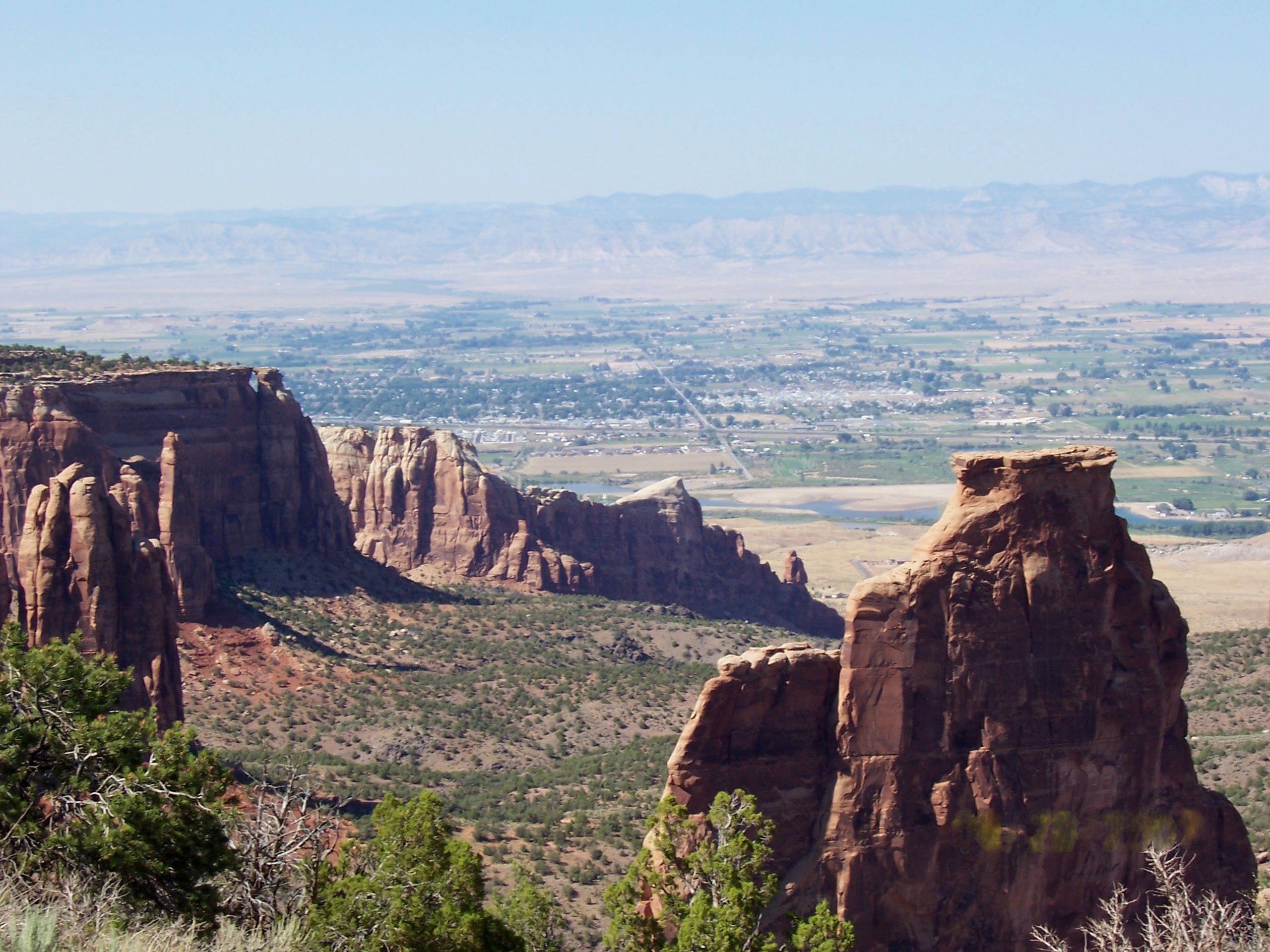
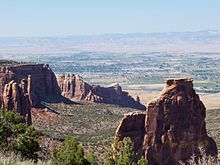 View of Fruita from the Colorado National Monument
There are hiking and horseback riding trails of variable lengths available in nearby McInnis Canyons National Conservation Area including Devil’s Canyon, Pollock Bench, Black Ridge Canyons Wilderness (Knowles Canyon, Mee Canyon, Moore Canyon, Rattlesnake Canyon), Colorado National Monument (Canyon Rim Trail, Coke Ovens Trail, Liberty Cap Trail, Monument Canyon Trail, Otto’s Trail, Serpent’s Trail, Window Rock Trail), Dinosaur Hill, Highline Lake State Park, and Rabbit Valley.
Parks
Town parks in Fruita include Circle Park at the junction of Mesa Street and Aspen Avenue, Comstock Park at 725 Galena Circle, Heritage Park at 210 I-70 Frontage Road, Little Salt Wash at 1135 18 Road, Raptor Skate Park at 273 North Cherry, Reed Park at 250 South Elm, Roberson Park at 280 West Roberson Drive, Triangle Park at 103 South Coulson Street, and Veteran’s Memorial Park at 342 Hwy 340. The James M. Robb Colorado River State Park encompasses 890 acres located on State Highway 340.
The Colorado National Monument is almost 20,500 acres (83 km2) of semi-arid wilderness, rising more than 2,000 feet (610 m) above the City of Fruita. Native wildlife, such as eagles, bighorn sheep, and mule deer can be seen in the area.
The Riverfront Trail system follows the Colorado River through Mesa County through cottonwood groves, wetlands, marshes. It is home to over 200 different species of birds, three endangered species of fish, and an abundance of small animals. The trail project is still in progress and plans to connect Fruita to Palisade via a paved recreation trail. The project is a collaboration of several cities, Mesa County, and state agencies and overseen by the Colorado Riverfront Commission.[15]
Rodeo
Rimrock Rodeo takes place from June through August every Tuesday evening through the Summer. A series of events showcase riders; a “Mutton Busing” Event; and the Professional Rodeo Riders “Grand Entry” Event.
Running
Fruita runners take part in town races such as the July PteRANodon Ptrot, February Sweet Heart Run and others as well as the annual Rim Rock marathon held in November atop the Colorado National Monument. Trail running is also popular and takes place on any of the hiking trails. The Desert RATS Trail Running Festival includes 5, 10, 25, and 50-mile (80 km) trail races in April, as well as the Desert RATS multi-day supported trail race along the Kokopelli's Trail from Loma to Moab.
Arts & Culture
The city is scattered with public art sculptures some metal, some stone. There are no private galleries, however, several businesses rotate displays of local artists work. Every summer the City of Fruita puts on a summer arts camp for children and adults. The natural landscape and recreation have inspired countless painters, photographers, and sculptures to create works of art. The Fruita Arts & Culture Board supports and advocates for artists and activities in town.
Major music events of the region include the Summer Thursday night concerts, Country Jam and Rock Jam in the nearby town of Mack. Shows also take place during the annual Fat Tire Festival and the Fruita Fall Festival.
The Mesa County Public Library - Fruita Branch is housed in the Fruita Community Center at 324 North Coulson Street. Nearly 7,000 square feet (650 m2), the facility includes a reading room with fireplace, program room and meeting rooms.
The Fruita Times newspaper, the Grand Junction Sentinel, and the Grand Junction Free Press serve the current events needs of the region.
There are several active civic groups including the Fruita Lions Club, Fruita Masons, and Fruita Rotary Club, as well as the non-profit Fruita Thrift shop that has been supporting the town's activities for over 50 years.
Tourism
Fruita town events include the summer Farmers Market, Summer Thursday night music concerts and arts & crafts fairs three times a year.
Fat Tire Festival
Single track mountain biking enthusiasts and friends have been celebrating the hundreds of miles of world class mountain bike trails around the area of Fruita and western Colorado at this festival since 1996. The three day fest includes races, live music every evening, a beer garden and legendary parties. Every year at the end of April. [6]
Mike The Headless Chicken Festival
Fruita is known for Mike the Headless Chicken, a rooster who lived for 18 months after his head was cut off. Lloyd Olsen, the remover of Mike's head, continued to give him food and water with an eye dropper. He grew to be almost 8 lb (3.6 kg). Mike went on to tour the country as a side show. A festival in his honor is held each May in Fruita.
Fruita Fall Festival
Voted Best of the West by The Daily Sentinel's readership in 2001, 2002, 2006, 2008 and 2009, the Fruita Fall Festival is the granddaddy of festivals on the Western Slope.This festival started in 1910 as a harvest festival for the local fruit production industry and has evolved to a major event. It includes three days of events with music, carnival rides, a parade, bed race, baking & canning contest, youth pet and talent show, two stages of music and arts and crafts vendors. The event is celebrated on the last full weekend in September.[16]
Transportation
Air
The nearest commercial airport is Grand Junction Regional Airport (GJT) in Grand Junction 19 miles (31 km) east. Allegiant Airlines, American Airlines, Skywest Airlines (flying as both United Express and Delta Connection) and US Airways provide direct service to Dallas/Fort Worth, Denver, Los Angeles, Las Vegas, Phoenix and Salt Lake City. Charter companies Colorado Flight Center and Denver Air Connection providing connections to nearby regional destinations.
Bus
Fruita is on Route 8 of the Grand Valley Transit, the operating regional bus transportation system. The bus connects Fruita stops with the Mesa Mall on US Route 6 & 50 at the 24 1/2 Road.
Highways
Fruita lies off exit 19 of Interstate 70, along US Route 6 & 50 and at the western end of State Highway 340. The State Highway 139 connects 5 miles (8.0 km) west with the northern city of Rangely and Dinosaur National Monument.
Rail
The nearest passenger train station is 11 miles (18 km) southeast located at 339 South 1st Street at the Grand Junction Amtrak station. This station is served by the California Zephyr train. It was originally built by the Denver and Rio Grande Western Railroad.
A Burlington Northern and Sante Fe mainline runs east-west along the city which serves industrial rail use.
Notable People
Charlie Glass (?-1937), popular African-American cowboy buried in the Elmwood Cemetery[17]
Will Minor, naturalist, journalist and author of Footprints in the trail and More Footprints in the Trail
John Otto (1870–1952), trailblazer and first superintendent of the Colorado National Monument
Elmer Riggs(1869–1963), paleontologist from the Chicago Field Museum[6]
Mabel Skinner, National Apple Queen 1910 Denver Exposition
James Van Pelt award winning science fiction author and Fruita Monument High School teacherSee also
- Colorado municipalities
- Colorado National Monument
- Fruitadens
- James M. Robb Colorado River State Park
- Old Spanish National Historic Trail
References
- ^ a b "Active Colorado Municipalities". State of Colorado, Department of Local Affairs. http://www.dola.state.co.us/dlg/local_governments/municipalities.html. Retrieved 2007-09-01.
- ^ "Colorado Municipal Incorporations". State of Colorado, Department of Personnel & Administration, Colorado State Archives. 2004-12-01. http://www.colorado.gov/dpa/doit/archives/muninc.html. Retrieved 2007-09-02.
- ^ City of Fruita. [1] "City Council", 2011-02-11
- ^ "US Board on Geographic Names". United States Geological Survey. 2007-10-25. http://geonames.usgs.gov. Retrieved 2008-01-31.
- ^ "ZIP Code Lookup" (JavaScript/HTML). United States Postal Service. http://zip4.usps.com/zip4/citytown.jsp. Retrieved September 22, 2007.
- ^ a b City of Fruita [2] "Town History", 2011-02-11
- ^ United States Bureau of Land Management. Landmark information panels.
- ^ a b Noel, Thomas J. (2007). Guide to Colorado's Historic Places: Sites Funded by the State Historical Fund. Westcliffe Publishers. ISBN 1565794931.
- ^ City of Fruita Historic Preservation Board. Fruita Historic Walking Tour Brochure.
- ^ "US Gazetteer files: 2010, 2000, and 1990". United States Census Bureau. 2011-02-12. http://www.census.gov/geo/www/gazetteer/gazette.html. Retrieved 2011-04-23.
- ^ Fruita Chamber of Commerce "Community Profile 2009", accessed February 11, 2011.
- ^ "American FactFinder". United States Census Bureau. http://factfinder.census.gov. Retrieved 2008-01-31.
- ^ Mesa State College. "About Mesa State College", 2010. accessed February 11, 2011.
- ^ Western Colorado Community College. [3]. 2010. accessed February 11, 2011.
- ^ Colorado Riverfront Commission, [4], What is the Riverfront Trail System, 2011-02-11
- ^ Fruita Area Chamber of Commerce, [5], Fruita Festivals, 2011-02-11
- ^ Wyman, Walker Demarquis, and John D Hart. The Legend of Charlie Glass, Negro Cowboy On the Colorado-Utah Range: . River Falls, Wis.: River Falls State University Press, 1970.
External links
Municipalities and communities of Mesa County, Colorado Cities Fruita | Grand Junction
Towns CDPs Clifton | Fruitvale | Orchard Mesa | Redlands
Unincorporated
communitiesGateway | Glade Park | Loma | Mack | Mesa | Molina | Whitewater
Ghost town Categories:- Populated places in Mesa County, Colorado
- Colorado Western Slope
- Cities in Colorado


Wikimedia Foundation. 2010.