- Dinosaur National Monument
-
Dinosaur National Monument

Location: Moffat County, Colorado / Uintah County, Utah, USA Nearest city: Vernal, UT Coordinates: 40°32′N 108°59′W / 40.53333°N 108.98333°WCoordinates: 40°32′N 108°59′W / 40.53333°N 108.98333°W Area: 210,844 acres (85,326 ha) Visitation: 360,584 (2005) Governing body: U.S. National Park Service MPS: Dinosaur National Monument Multiple Resource Area (MRA) NRHP Reference#: n/a (the Monument is an MRA) Designated NMON: October 4, 1915[1] Dinosaur National Monument is a National Monument located on the southeast flank of the Uinta Mountains on the border between Colorado and Utah at the confluence of the Green and Yampa Rivers. Although most of the monument area is in Moffat County, Colorado, the Dinosaur Quarry 40°26′29″N 109°18′04″W / 40.44139°N 109.30111°W is located in Utah just to the north of the town of Jensen, Utah. The nearest communities are Vernal, Utah and Dinosaur, Colorado. This park has fossils of dinosaurs including Allosaurus, Abydosaurus (a nearly complete skull, lower jaws and first four neck vertebrae of the specimen DINO 16488 found here at the base of the Mussentuchit Member of the Cedar Mountain Formation is the holotype for the description) and various long-neck, long-tail sauropods. It was declared a National Monument on October 4, 1915.[1]
Contents
Geology
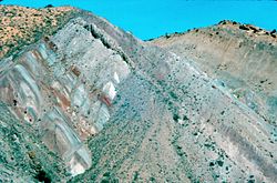
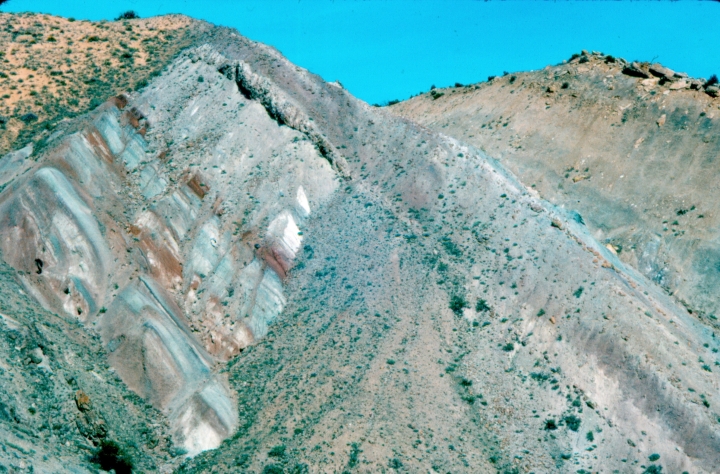
The rock layer enclosing the fossils is a sandstone and conglomerate bed of alluvial or river bed origin known as the Morrison Formation from the Jurassic Period some 150 million years old. The dinosaurs and other ancient animals were washed into the area and buried presumably during flooding events. The pile of sediments were later buried and lithified into solid rock. The layers of rock were later uplifted and tilted to their present angle by the mountain building forces that formed the Uintas. The relentless forces of erosion exposed the layers at the surface to be found by paleontologists.
History
The dinosaur fossil beds (bone beds) were discovered in 1909 by Earl Douglass, a paleontologist working and collecting for the Carnegie Museum.[2] He and his crews excavated thousands of fossils and shipped them back to the museum in Pittsburgh, Pennsylvania for study and display. President Woodrow Wilson proclaimed the dinosaur beds as Dinosaur National Monument in 1915. The monument boundaries were expanded in 1938 from the original 80-acre (320,000 m2) tract surrounding the dinosaur quarry in Utah, to its present extent of over 200,000 acres (800 km²) in Utah and Colorado, encompassing the spectacular river canyons of the Green and Yampa.
Though lesser-known than the fossil beds, the petroglyphs in Dinosaur National Monument are another treasure the monument holds. Due to problems with vandals, many of the sites are not listed on area maps.[citation needed]
Places on the list of National Register of Historic Places include:[3]
- Prehistoric sites
- Castle Park Archeological District, a prehistoric residential site with inhabition during 1500 - 1000 BC and again from AD 1000 - 1899 by the Prehistoric Fremont culture, Ute and Shoshone people.
- Mantle's Cave is a prehistoric Fremont culture residential site from 499 BC - AD 1749.
- Historic sites in the Dinosaur National Monument
- Denis Julien Inscription
- Rial Chew Ranch Complex
- Upper Wade and Curtis Cabin
Climate
The Dinosaur National Monument sits on a vast area of desert land in Northwestern Colorado and Northeastern Utah. Typical of "high deserts", summer temperatures can be exceedingly hot, while winter temperatures can be very cold. Snowfall is common, but the snow melts rapidly in the arid and sunny climates of these states. Rainfall is very low, and the evaporation rate classifies the area as desert, even though the rainfall just barely exceeds 10 inches.
Climate data for Dinosaur National Monument Month Jan Feb Mar Apr May Jun Jul Aug Sep Oct Nov Dec Year Average high °F (°C) 33.0
(0.6)39.0
(3.9)50.4
(10.2)60.8
(16.0)71.9
(22.2)83.2
(28.4)90.5
(32.5)87.9
(31.1)77.7
(25.4)63.6
(17.6)45.7
(7.6)34.2
(1.2)61.5 Average low °F (°C) 10.8
(−11.8)15.2
(−9.3)25.0
(−3.9)31.8
(−0.1)40.5
(4.7)48.9
(9.4)56.6
(13.7)54.7
(12.6)45.5
(7.5)34.9
(1.6)23.3
(−4.8)12.7
(−10.7)33.3 Precipitation inches (mm) 0.64
(16.3)0.56
(14.2)0.88
(22.4)1.17
(29.7)1.30
(33)1.06
(26.9)1.01
(25.7)0.89
(22.6)1.24
(31.5)1.46
(37.1)0.80
(20.3)0.62
(15.7)11.64
(295.7)Snowfall inches (cm) 9.2
(23.4)6.6
(16.8)5.9
(15)3.5
(8.9)0.7
(1.8)0.2
(0.5)0.0
(0)0.0
(0)0.2
(0.5)1.6
(4.1)4.7
(11.9)8.3
(21.1)41.1
(104.4)Source: http://www.wrcc.dri.edu/summary/climsmco.html [4] The Quarry
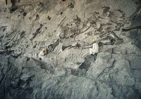
The Dinosaur wall located within the Dinosaur Quarry building in the park consists of a steeply tilted (67° from horizontal) rock layer which contains hundreds of dinosaur fossils. The enclosing rock has been chipped away to reveal the fossil bones intact for public viewing. In July 2006, the Quarry Visitor Center was closed indefinitely due to structural problems that have plagued the building since 1957 as it was built on unstable clay. The current preferred plan is to rehabilitate the existing Quarry building, destroying the serpentine ramp, administrative, and museum facilities. A new facility to house the visitor center and administrative functions would be constructed elsewhere in the monument. This plan would provide a safe structure while still retaining a portion of the historic Mission 66 era exhibit hall.[5] It was announced in April 2009 that Dinosaur National Monument would receive $13.1 million to refurbish and reopen the gallery as part of President Obama's administration $750 billion stimulus plan.[6]
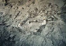
. The Park Service successfully rebuilt the Quarry Structure and the Quarry was reopened in Fall 2011.Vertebrate Fossils from Carnegie Quarry
 Workers inside the Dinosaur Quarry building
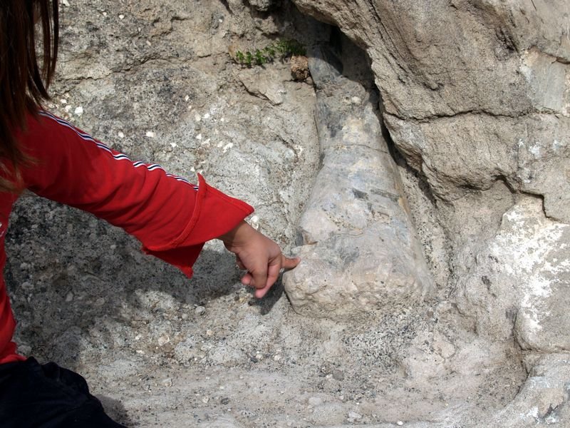
 Young girl pointing at a dinosaur's humerus bone on the Fossil Discovery Trail
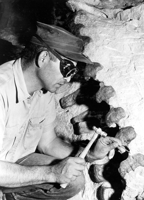
 Paleontologist carefully chips rock matrix from a column of dinosaur vertebrae. These bones were left in place in the Dinosaur Quarry display.
- Now enclosed by the Dinosaur Quarry building (Gilmore (1936), Foster (2003))
- (h) = holotype
- Reptilia
- Testudines
- Amphichelydia
- Glyptops plicatus
- Dinochelys whitei
- Amphichelydia
- Rhynchocephalia
-
- Opisthias rarus
-
- Crocodilia
- Mesosuchia
- Gonipholididae
- Goniopholis sp.
- Atoposauridae
- Hoplosuchus kayi (h)
- Gonipholididae
- Mesosuchia
- Dinosauria
- Saurischia
- Theropoda
- Ceratosaurus sp.
- Torvosaurus sp.
- Allosaurus fragilis
- Sauropoda
- Apatosaurus louisae (h)
- Barosaurus lentus
- Camarasaurus lentus
- Diplodocus "longus"
- ?Haplocanthosaurus sp.
- Uintasaurus douglassi (h) (now Camarasaurus lentus)
- Theropoda
- Ornithischia
- Stegosauria
- Stegosaurus sp.
- Ornithopoda
- Iguanodontia
- Uteodon aphanoecetes {h)
- Dryosauridae
- Dryosaurus altus
- Stegosauria
Echo Park Dam controversy
U.S. Bureau of Reclamation plans for a ten-dam, billion dollar Colorado River Storage Project began to arouse opposition in the early 1950s when it was announced that one of the proposed dams would be at Echo Park, in the middle of Dinosaur National Monument. The controversy assumed major proportions, dominating conservation politics for years. David Brower, executive director of the Sierra Club, and Howard Zahniser of The Wilderness Society led an unprecedented nationwide campaign to preserve the free-flowing rivers and scenic canyons of the Green and Yampa Rivers. They argued that, if a national monument was not safe from development, how could any wildland be kept intact?
On the other side of the argument were powerful members of Congress from western states, who were committed to the project in order to secure water rights, obtain cheap hydroelectric power and develop reservoirs as tourist destinations. After much debate, Congress settled on a compromise that eliminated Echo Park Dam and authorized the rest of the project. The Colorado River Storage Project Act became law on April 11, 1956. It stated, “that no dam or reservoir constructed under the authorization of the Act shall be within any National Park or Monument.”
Historians view the Echo Park Dam controversy as signaling the start of an era that includes major conservationist political successes such as the Wilderness Act and the Wild and Scenic Rivers Act.
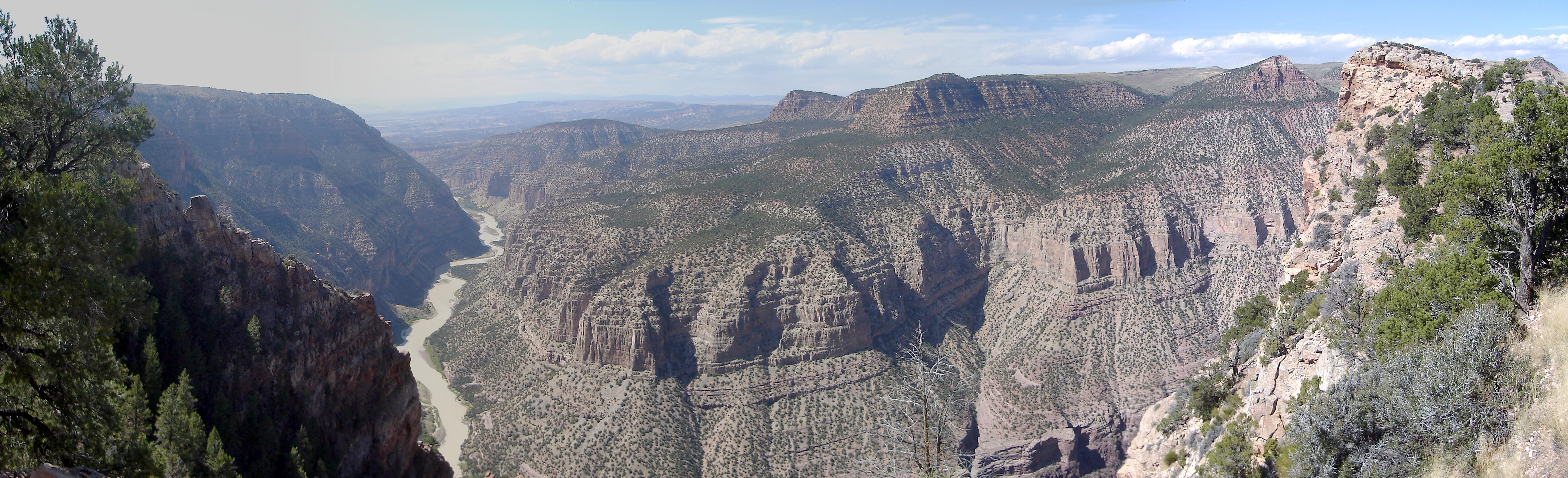
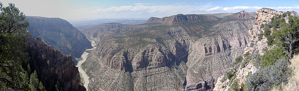 Green River Canyon in Dinosaur National Monument
References
- Jon M. Cosco, Echo Park: Struggle for Preservation (Johnson Books, 1995) ISBN 1-55566-140-8
- John R.Foster, 2003. Paleoecological analysis of the vertebrate fauna of the Morrison Formation (Upper Jurassic), Rocky Mountain region, USA. New Mexico Museum of Natural History and Science 23:1-95
- Charles W. Gilmore, 1936, Osteology of Apatosaurus, with special references to specimens in the Carnegie Museum. Memoirs of the Carnegie Museum 11(4): 177-294.
- Mark W.T. Harvey, A Symbol of Wilderness: Echo Park and the American Conservation Movement (University of Washington Press, 2000) ISBN 0-295-97932-1
- ^ a b "Dinosaur National Monument Statistics". NPS. January 11, 2008. http://www.nps.gov/dino/parkmgmt/statistics.htm. Retrieved 2009-03-21.
- ^ "Speak to the earth and it will teach you : the life and times of Earl Douglass, 1862-1931 (Book, 2009) [WorldCat.org"]. http://www.worldcat.org/title/speak-to-the-earth-and-it-will-teach-you-the-life-and-times-of-earl-douglass-1862-1931/oclc/460630935&referer=brief_results. Retrieved 2011-10-13.
- ^ National Register of Historic Places in Moffat County American Dreams, Inc. Retrieved 2011-10-6.
- ^ http://www.wrcc.dri.edu/cgi-bin/cliMAIN.pl?codino
- ^ "Draft Environmental Impact Statement for Quarry Visitor Center, Part 1" (PDF). National Park Service. March 2007. http://parkplanning.nps.gov/showFile.cfm?projectId=10847&docType=public&MIMEType=application%252Fpdf&filename=DINOQVCpublicreview%5Fpost1%2Epdf&clientFilename=DINOQVCpublicreview%5Fpost1%2Epdf. Retrieved 2008-02-11.
- ^ "$13.1M in stimulus cash revives dino monument". Salt Lake Tribune. April 2009. http://www.sltrib.com/utah/ci_12200345?source=rv. Retrieved 2009-04-23.
External links
- Dinosaur National Monument official park site
- National Park Service Douglass Quarry
- Dinosaur National Monument
- Canyon Country Hiking and Camping Notebook: Dinosaur National Monument
Protected Areas of the State of Colorado Federal National ParksNational MonumentsNational Recreation AreasNational Historic SitesNational Historic TrailsOld Spanish Trail · Pony Express Trail · Santa Fe TrailNational Scenic TrailContinental Divide TrailArapaho · Grand Mesa · Gunnison · Pike · Rio Grande · Roosevelt · Routt · San Isabel · San Juan · Uncompahgre · White RiverNational WildernessBlack Canyon of the Gunnison · Black Ridge Canyons · Buffalo Peaks · Byers Peak · Cache La Poudre · Collegiate Peaks · Comanche Peak · Dominguez · Eagles Nest · Flat Tops · Fossil Ridge · Great Sand Dunes · Greenhorn Mountain · Gunnison Gorge · Holy Cross · Hunter-Fryingpan · Indian Peaks · James Peak · La Garita · Lizard Head · Lost Creek · Maroon Bells-Snowmass · Mesa Verde · Mount Evans · Mount Massive · Mount Sneffels · Mount Zirkel · Neota · Never Summer · Platte River · Powderhorn · Ptarmigan Peak · Raggeds · Rawah · Sangre de Cristo · Sarvis Creek · South San Juan · Spanish Peaks · Uncompahgre · Vasquez Peak · Weminuche · West ElkNational Conservation AreasNational Wildlife RefugesAlamosa · Arapaho · Baca · Browns Park · Monte Vista · Rocky Flats · Rocky Mountain Arsenal · Two PondsState Arkansas Headwaters · Barr Lake · Bonny Lake · Boyd Lake · Castlewood Canyon · Chatfield · Cherry Creek · Cheyenne Mountain · Crawford · Eldorado Canyon · Eleven Mile · Golden Gate Canyon · Harvey Gap · Highline Lake · Jackson Lake · James M. Robb - Colorado River · John Martin Reservoir · Lake Pueblo · Lathrop · Lone Mesa · Lory · Mancos · Mueller · Navajo · North Sterling · Paonia · Pearl Lake · Ridgway · Rifle Falls · Rifle Gap · Roxborough · San Luis · Spinney Mountain · St. Vrain · Stagecoach · State Forest · Staunton · Steamboat Lake · Sweitzer Lake · Sylvan Lake · Trinidad Lake · Vega · Yampa RiverByers-Evans House · Colorado History Museum · El Pueblo · Fort Garland · Fort Vasquez · Georgetown Loop · Healy House Museum and Dexter Cabin · Pearce-McAllister Cottage · Pike Stockade · Trinidad History Museum · Ute Indian MuseumOther Beaver Meadows · Burlington Carousel · Black Hawk · Central City · Colorado Chautauqua · Cripple Creek · Durango-Silverton Railroad · Georgetown · Granada · Leadville · Lindenmeier Site · Lowry Ruin · Mesa Verde · Pikes Peak · Pike's Stockade · Raton Pass · Shenandoah-Dives Mill · Silver Plume · Silverton · Telluride · U.S. Air Force Academy Cadet AreaGarden of the Gods · Garden Park Fossil Area · Indian Springs Trace Fossil · Lost Creek Scenic Area · Morrison Fossil Area · Raton Mesa · Roxborough Park · Russell Lakes · Sand Creek · Slumgullion Earthflow · Spanish Peaks · Summit LakeAmerican Discovery Trail · Colorado Trail · Continental Divide Trail · Great Divide Trail · Kokopelli's Trail · Paradox Trail · Tabeguache TrailAlpine Loop · Cache la Poudre-North Park · Colorado River Headwaters · Dinosaur Diamond · Flat Tops · Frontier Pathways · Gold Belt · Grand Mesa · Guanella Pass · Highway of Legends · Lariat Loop · Los Caminos Antiguos · Mount Evans · Pawnee Pioneer · Peak to Peak · San Juan Skyway · Santa Fe Trail · Silver Thread · South Platte River Trail · Top of the Rockies · Trail of the Ancients · Trail Ridge · Unaweep/Tabeguache · West Elk LoopProtected Areas of Utah Federal National ParksNational MonumentsNational Historic SitesDesert Biosphere Reserve • Flaming Gorge National Recreation Area • Glen Canyon National Recreation Area • Mormon Pioneer National Historic TrailNational Wildlife Refuges:Ashdown Gorge • Beartrap Canyon • Beaver Dam Mountains • Black Ridge Canyons • Blackridge • Box-Death Hollow • Canaan Mountain • Cedar Mountain • Cottonwood Canyon • Cottonwood Forest • Cougar Canyon • Dark Canyon • Deep Creek • Deep Creek North • Deseret Peak • Doc's Pass • Goose Creek • High Uintas • LaVerkin Creek • Lone Peak • Mount Naomi • Mount Nebo • Mount Olympus • Mount Timpanogos • Paria Canyon-Vermilion Cliffs • Pine Valley Mountain • Red Mountains • Slaughter Creek • Taylor Creek • Twin Peaks • Wellsville Mountain • Zion
State Antelope Island • Bear Lake • Camp Floyd • Deer Creek • East Canyon • Flight Park • Great Salt Lake • Historic Rail Trail • Hyrum • Jordan River OHV Park • Jordanelle • Red Fleet • Rockport • Starvation • Steinaker • Utah Field House • Utah Lake • Wasatch Mountain • Willard Bay
Fremont Indian • Goblin Valley • Green River • Huntington • Millsite • Palisade • Scofield • Territorial Statehouse • Yuba
Anasazi • Coral Pink Sand Dunes • Dead Horse Point • Edge of the Cedars • Escalante Petrified Forest • Frontier Homestead • Goosenecks • Gunlock • Kodachrome Basin • Otter Creek • Piute • Quail Creek • Sand Hollow • Snow Canyon
Municipal Municipal parksFort Buenaventura • Gallivan Center • Liberty Park • Jordan River Parkway • Minersville Reservoir • Murray City Park • Sugar House Park • Veterans Memorial Park
U.S. National Register of Historic Places Topics Lists by states Alabama • Alaska • Arizona • Arkansas • California • Colorado • Connecticut • Delaware • Florida • Georgia • Hawaii • Idaho • Illinois • Indiana • Iowa • Kansas • Kentucky • Louisiana • Maine • Maryland • Massachusetts • Michigan • Minnesota • Mississippi • Missouri • Montana • Nebraska • Nevada • New Hampshire • New Jersey • New Mexico • New York • North Carolina • North Dakota • Ohio • Oklahoma • Oregon • Pennsylvania • Rhode Island • South Carolina • South Dakota • Tennessee • Texas • Utah • Vermont • Virginia • Washington • West Virginia • Wisconsin • WyomingLists by territories Lists by associated states Other Categories:- Dinosaur National Monument
- Landmarks in Colorado
- Dinosaur museums in the United States
- Natural history museums in Utah
- Museums in Uintah County, Utah
- Protected areas established in 1915
- Protected areas of Uintah County, Utah
- Protected areas of Moffat County, Colorado
- Prehistoric sites

Wikimedia Foundation. 2010.