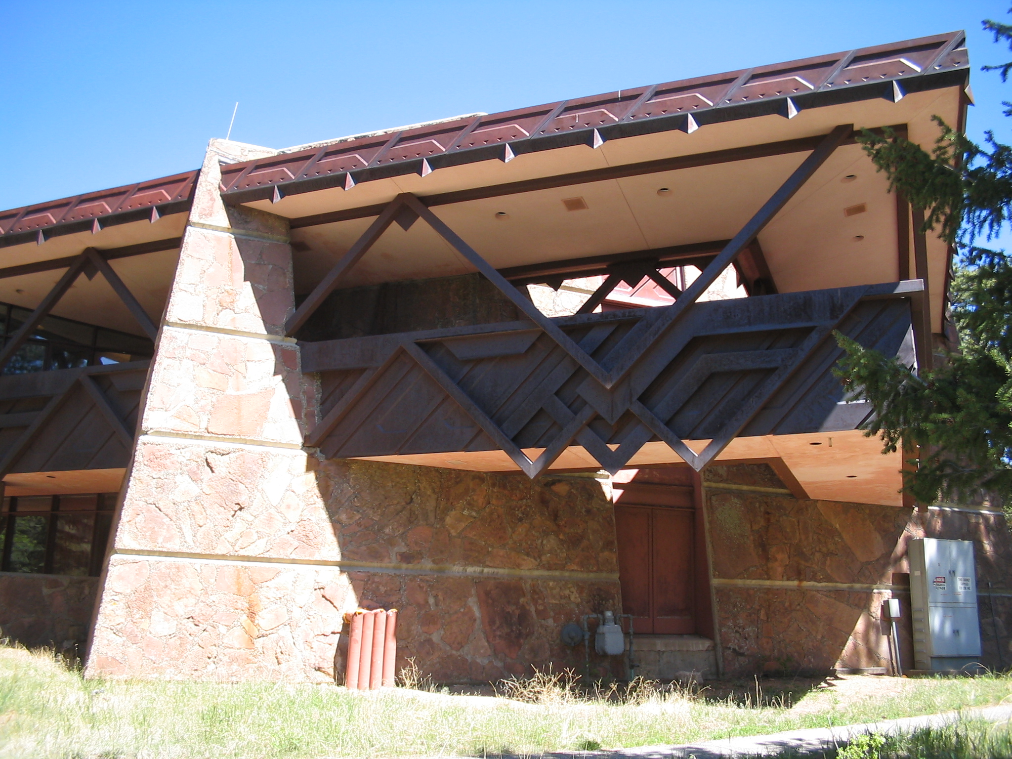
Beaver Meadows Visitor Center
- Beaver Meadows Visitor Center
Infobox_nrhp2 | name =Rocky Mountain National Park Administration Building
nhl=yes

caption =
location= Rocky Mountain National Park, Estes, Colorado
locmapin = Colorado
lat_degrees = 40
lat_minutes = 21
lat_seconds = 58
lat_direction = N
long_degrees = 105
long_minutes = 33
long_seconds = 39
long_direction = W
area =
architect= Taliesin Associated Architects
architecture=
designated_nhl= January 03, 2001[cite web|url=http://tps.cr.nps.gov/nhl/detail.cfm?ResourceId=2671239&ResourceType=Building]
title=Rocky Mountain National Park Administration Building |accessdate=2007-10-15|work=National Historic Landmark summary listing|publisher=National Park Service]
added = January 03, 2001[cite web|url=http://www.nr.nps.gov/|title=National Register Information System|date=2007-01-23|work=National Register of Historic Places|publisher=National Park Service] ]
governing_body = National Park Service
mpsub=Rocky Mountain National Park MRA
refnum=01000069
Beaver Meadows Visitor Center, also known as Rocky Mountain National Park Administration Building, is a building in Rocky Mountain National Park that is nationally significant for its architecture. Completed in 1967, it was designed by Taliesin Associated Architects, and was one of the most significant commissions for that firm in the years immediately following the death of founder Frank Lloyd Wright [ [http://tps.cr.nps.gov/nhl/detail.cfm?ResourceId=2671239&ResourceType=Building| National Historic Landmark summary] "National Historic Landmarks Program, accessed 31 October, 2007"] . It was one of the last major projects completed under the Park Service Mission 66 project.
It was declared a National Historic Landmark in 2001.[citation|title=PDFlink| [http://pdfhost.focus.nps.gov/docs/NHLS/Text/01000069.pdf National Register of Historic Places Inventory-Nomination: Rocky Mountain National Park Administration Building / Headquarters Building / Beaver Meadows Visitor Center] |1.54 MB|date=September 1, 2000 |author=Sarah Allaback and Ethan Carr |publisher=National Park Service and PDFlink| [http://pdfhost.focus.nps.gov/docs/NHLS/Photos/01000069.pdf Accompanying 7 photos, exterior and interior, from 1982 and 1999.] |2.08 MB] ]References
External links
* [http://www.nps.gov/ROMO/ Rocky Mountain National Park Official Site]
* [http://www.fodors.com/miniguides/mgresults.cfm?destination=rocky_mountain@622&cur_section=sig&property_id=341490 Beaver Meadows Visitor Center, described in Fodors guidebook]
Wikimedia Foundation.
2010.
Look at other dictionaries:
Mission 66 — Dinosaur Quarry Visitor Center, Dinosaur National Monument, prior to 2009 Mission 66 was a US National Park Service ten year program that was intended to dramatically expand Park Service visitor services by 1966, in time for the 50th anniversary… … Wikipedia
Rocky Mountain National Park — Infobox Protected area name = Rocky Mountain National Park iucn category = II nrhp type = hd | caption = locator x = 96 locator y = 78 location = Larimer, Grand, Boulder counties, Colorado, USA nearest city = Estes Park coords =… … Wikipedia
List of National Historic Landmarks in Colorado — This is a List of National Historic Landmarks in Colorado. A list of National Park Service administered areas in Colorado that have a historic focus is also included. There are 21 National Historic Landmark sites in Colorado.[1] Contents 1… … Wikipedia
National Register of Historic Places listings in Rocky Mountain National Park — This is a list of the National Register of Historic Places listings in Rocky Mountain National Park. This is intended to be a complete list of the properties and districts on the National Register of Historic Places in Rocky Mountain National… … Wikipedia
Liste der National Historic Landmarks in Colorado — Diese Liste der National Historic Landmarks in Colorado führt alle Objekte und Stätten im US amerikanischen Bundesstaat Colorado auf, die in diesem US Bundesstaat als National Historic Landmark (NHL) eingestuft sind und unter der Aufsicht des… … Deutsch Wikipedia
U.S. Route 36 in Colorado — This article is about the section of U.S. Route 36 in Colorado. For the entire length of the highway, see U.S. Route 36. U.S. Route 36 Denver Boulder Turnpike … Wikipedia
List of nature centers in the United States — NOTOC ListByUSStateTOC center=yes bottom left=yes washington dc=yes territories=yes seealso=yesAlabama* [http://www.biophilia.net Biophilia Nature Center] (Elberta, Alabama) * [http://www.outdooralabama.com/public lands/stateLands/WNC/ Gatra… … Wikipedia
John Day Fossil Beds National Monument — Coordinates: 44°33′21″N 119°38′43″W / 44.55583°N 119.64528°W / 44.55583; 119.64528 … Wikipedia
Death Valley National Park — IUCN Category II (National Park) … Wikipedia
Yosemite National Park — Infobox Protected area name = Yosemite National Park iucn category = Ib caption = locator x = 20 locator y = 84 location = Tuolumne, Mariposa, Madera Counties, California, USA nearest city = Mariposa lat degrees = 37 lat minutes = 50 lat seconds … Wikipedia

