- Anasazi State Park Museum
-
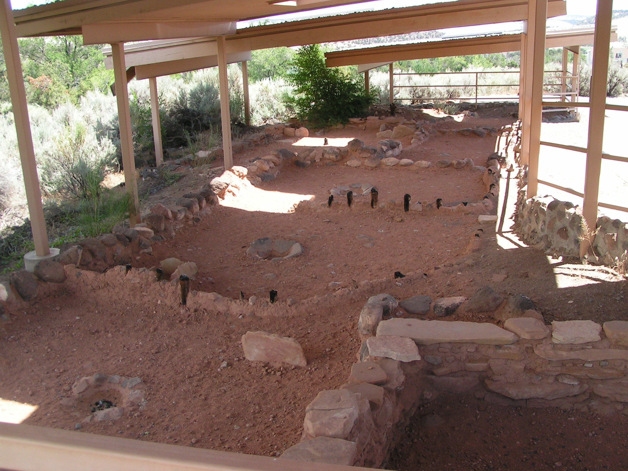
Anasazi State Park Museum Utah State Park 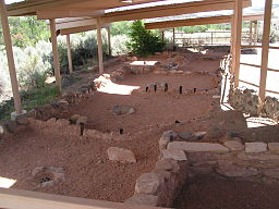 Ancient Anasazi ruins at Anasazi State Park Museum
Named for: the Anasazi people Country  United States
State  Utah
UtahCounty Garfield Location Boulder - elevation 6,700 ft (2,042 m) [1] - coordinates 37°54′39″N 111°25′24″W / 37.91083°N 111.42333°W Area 6 acres (2.4 ha) [2] Founded 1960 [2] Management Utah State Parks Visitation 21,760 (2010) [3] 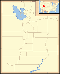
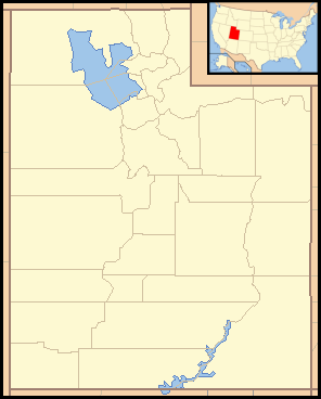
 Location of Anasazi State Park Museum in Utah
Anasazi State Park Museum is a state park and museum in Southern Utah, USA, featuring the ruins of an ancient Anasazi village referred to as the Coombs Village Site.
Contents
Park facilities
Established as a Utah state park in 1960, the 6-acre (2.4 ha) Anasazi State Park Museum is open year-round, and features a visitor center, a museum with examples of Anasazi pottery and other artifacts, a museum store, an auditorium, and picnic areas. There is no camping. It is located in Boulder, Utah, at the edge of 11,000-foot-tall (3,400 m) Boulder Mountain.[4]
The park is focused around the reconstructed ruins of an ancient Anasazi village, referred to as the Coombs Village Site, which is located directly behind the museum. There is a self-guided trail visitors can take through the village with interpretive signs explaining the various features of the village, and the culture of the people who once lived there.
Archaeological Coombs Site
The Coombs Site is the site of one of the largest Anasazi communities known to have existed west of the Colorado River. The name Anasazi, Navajo for "Ancient Enemies," or "Enemies of Our Ancestors" describes the Pueblo culture that existed in the Four Corners area from about 1 AD to 1300 AD. This village is believed to have been occupied from 1160 AD to 1235 AD. As many as 250 people lived there.[1]
The village is largely unexcavated, though there was a brief excavation during 1958 and 1959, conducted by the University of Utah as part of the Glen Canyon Dam Project. During that excavation, archeologists uncovered thousands of artifacts, and discovered a community of about 90 rooms divided into two separate one-story apartment complexes. An L-shaped building has been reconstructed and can be entered into by visitors. The cluster featured open shelters for working in the shade, storage pits, and adobe pit houses large enough for five or six residents. All together, about 100 structures have been found.
Evidence, such as singed structural building supports, suggest that the town was abandoned after a village-wide fire. There was also a serious drought occurring in the region during that time that may have also been a factor.
References
- ^ a b "Anasazi State Park Museum: About the Park". Utah State Parks. http://stateparks.utah.gov/parks/anasazi/about. Retrieved 2011-02-4.
- ^ a b "Anasazi State Park Museum Resource Management Plan". Utah Division of State Parks and Recreation, Planning Section. 2009-03. http://static.stateparks.utah.gov/plans/RMP_Anasazi09.pdf. Retrieved 2011-02-04.
- ^ "Utah State Park Visitation". Utah State Parks Planning. http://stateparks.utah.gov/about/visitation. Retrieved 2011-02-04.
- ^ "Anasazi State Park Museum". Utah State Parks. http://stateparks.utah.gov/parks/anasazi.
External links
Protected Areas of Utah Federal National ParksNational MonumentsNational Historic SitesDesert Biosphere Reserve • Flaming Gorge National Recreation Area • Glen Canyon National Recreation Area • Mormon Pioneer National Historic TrailNational Wildlife Refuges:Bear River Migratory Bird Refuge • Fish Springs • OurayAshdown Gorge • Beartrap Canyon • Beaver Dam Mountains • Black Ridge Canyons • Blackridge • Box-Death Hollow • Canaan Mountain • Cedar Mountain • Cottonwood Canyon • Cottonwood Forest • Cougar Canyon • Dark Canyon • Deep Creek • Deep Creek North • Deseret Peak • Doc's Pass • Goose Creek • High Uintas • LaVerkin Creek • Lone Peak • Mount Naomi • Mount Nebo • Mount Olympus • Mount Timpanogos • Paria Canyon-Vermilion Cliffs • Pine Valley Mountain • Red Mountains • Slaughter Creek • Taylor Creek • Twin Peaks • Wellsville Mountain • Zion
State Antelope Island • Bear Lake • Camp Floyd • Deer Creek • East Canyon • Flight Park • Great Salt Lake • Historic Rail Trail • Hyrum • Jordan River OHV Park • Jordanelle • Red Fleet • Rockport • Starvation • Steinaker • Utah Field House • Utah Lake • Wasatch Mountain • Willard Bay
Fremont Indian • Goblin Valley • Green River • Huntington • Millsite • Palisade • Scofield • Territorial Statehouse • Yuba
Anasazi • Coral Pink Sand Dunes • Dead Horse Point • Edge of the Cedars • Escalante Petrified Forest • Frontier Homestead • Goosenecks • Gunlock • Kodachrome Basin • Otter Creek • Piute • Quail Creek • Sand Hollow • Snow Canyon
Municipal Municipal parksFort Buenaventura • Gallivan Center • Liberty Park • Jordan River Parkway • Minersville Reservoir • Murray City Park • Sugar House Park • Veterans Memorial Park
Categories:- Archaeological sites in Utah
- Archaeology museums in the United States
- Landmarks in Utah
- Museums in Garfield County, Utah
- National Register of Historic Places in Utah
- Native American history of Utah
- Native American museums in Utah
- Oasisamerica cultures
- Protected areas established in 1960
- Puebloan buildings and structures
- Ruins in the United States
- Utah state parks
- Protected areas of Garfield County, Utah

Wikimedia Foundation. 2010.