- Manti-La Sal National Forest
-
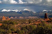
 La Sal mountain range as seen from Arches National Park.
The Manti-La Sal National Forest covers 1,270,646 acres (5,142.1 km2)[1] and is located in the central and southeastern parts of the U.S. state of Utah and the extreme western part of Colorado. The forest is divided into three districts: the La Sal District at Moab in the La Sal Range near Moab, in the La Sal District at Monticello in the Abajo Mountains west of Monticello, and the Manti Division on the Wasatch Plateau west of Price.[2] The maximum elevation is Mount Peale in the La Sal Mountains, reaching 12,721 feet (3,877 m) above sea level. The La Sal's are the second highest mountain range in Utah after the Uintas.
The La Sal Mountain loop road leads from Castle Valley to Geyser Pass and back down to Moab. Scenic Oowah Lake can be found within the forest.
In descending order of land area, the forest is located in parts of San Juan, Sanpete, Emery, Utah, Grand, Carbon, and Sevier counties in Utah, as well as Montrose, and Mesa counties in Colorado. Only about 2.1% of the forest lies in Colorado.) Forest headquarters is located in Price, Utah. There are local ranger district offices in Ephraim, Ferron, Moab, Monticello, and Price.[3]
The forest was originally established as the Manti Forest Reserve by the General Land Office on May 29, 1903 with 584,640 acres (2,366.0 km2). On July 1, 1915 Nebo National Forest was added, and La Sal National Forest on November 11, 1949. On August 28, 1958 the name became Manti-La Sal National Forest.[4]
Manti La Sal National Forest is very popular for recreation. The northern district on the Wasatch Plateau is well known for the Skyline Drive, an unpaved road tracing along the backbone of the plateau. There is also an extensive ATV trail system in the forest there. The Moab District in the La Sal Mountains contains excellent hiking, as well as spectacular views over the desert regions of Canyonlands National Park and Arches National Park. The Monticello District is home the Manti La Sal National Forest's only wilderness area, the Dark Canyon Wilderness, a vast, remote canyon area. [5]
See also
References
- ^ Table 6 - NFS Acreage by State, Congressional District, and County, 30 September 2008
- ^ http://www.fs.fed.us/r4/mantilasal/
- ^ USFS Ranger Districts by State
- ^ Davis, Richard C. (September 29, 2005), National Forests of the United StatesPDF (341 KB), The Forest History Society
- ^ http://www.utah.com/nationalsites/manti_lasal.htm
External links
Coordinates: 38°31′34″N 109°15′20″W / 38.526144°N 109.255600°W
Protected Areas of Utah Federal National ParksNational MonumentsNational Historic SitesDesert Biosphere Reserve • Flaming Gorge National Recreation Area • Glen Canyon National Recreation Area • Mormon Pioneer National Historic TrailNational Wildlife Refuges:Bear River Migratory Bird Refuge • Fish Springs • OurayAshdown Gorge • Beartrap Canyon • Beaver Dam Mountains • Black Ridge Canyons • Blackridge • Box-Death Hollow • Canaan Mountain • Cedar Mountain • Cottonwood Canyon • Cottonwood Forest • Cougar Canyon • Dark Canyon • Deep Creek • Deep Creek North • Deseret Peak • Doc's Pass • Goose Creek • High Uintas • LaVerkin Creek • Lone Peak • Mount Naomi • Mount Nebo • Mount Olympus • Mount Timpanogos • Paria Canyon-Vermilion Cliffs • Pine Valley Mountain • Red Mountains • Slaughter Creek • Taylor Creek • Twin Peaks • Wellsville Mountain • Zion
State Antelope Island • Bear Lake • Camp Floyd • Deer Creek • East Canyon • Flight Park • Great Salt Lake • Historic Rail Trail • Hyrum • Jordan River OHV Park • Jordanelle • Red Fleet • Rockport • Starvation • Steinaker • Utah Field House • Utah Lake • Wasatch Mountain • Willard Bay
Fremont Indian • Goblin Valley • Green River • Huntington • Millsite • Palisade • Scofield • Territorial Statehouse • Yuba
Anasazi • Coral Pink Sand Dunes • Dead Horse Point • Edge of the Cedars • Escalante Petrified Forest • Frontier Homestead • Goosenecks • Gunlock • Kodachrome Basin • Otter Creek • Piute • Quail Creek • Sand Hollow • Snow Canyon
Municipal Municipal parksFort Buenaventura • Gallivan Center • Liberty Park • Jordan River Parkway • Minersville Reservoir • Murray City Park • Sugar House Park • Veterans Memorial Park
Utah State Parks and Recreation Categories:- National Forests of Colorado
- National Forests of Utah
- Protected areas of San Juan County, Utah
- Protected areas of Sanpete County, Utah
- Protected areas of Emery County, Utah
- Protected areas of Grand County, Utah
- Protected areas of Carbon County, Utah
- Protected areas of Sevier County, Utah
- Protected areas of Utah County, Utah
- Protected areas of Montrose County, Colorado
- Protected areas of Mesa County, Colorado
- Utah geography stubs
Wikimedia Foundation. 2010.


