- Dinosaur, Colorado
-
Town of Dinosaur, Colorado — Town — Location in Moffat County and the State of Colorado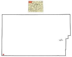
Coordinates: 40°14′30″N 109°0′31″W / 40.24167°N 109.00861°WCoordinates: 40°14′30″N 109°0′31″W / 40.24167°N 109.00861°W Country  United States
State  State of Colorado
County Moffat County[1] Incorporated 1947-12-09, as the Town of Artesia[2] Government – Type Statutory Town[1] Area – Total 0.8 sq mi (2.1 km2) – Land 0.8 sq mi (2.1 km2) – Water 0 sq mi (0 km2) Elevation[3] 5,922 ft (1,805 m) Population (2000) – Total 319 – Density 398.8/sq mi (151.9/km2) Time zone MST (UTC-7) – Summer (DST) MDT (UTC-6) ZIP codes[4] 81610 & 81633 Area code(s) 970 FIPS code 08-20495 GNIS feature ID 0171542 The Town of Dinosaur is a Statutory Town located in Moffat County, Colorado, United States. The town population was 320 at the U.S. Census 2000.
The town of Dinosaur was originally named Artesia; the current name was adopted in 1966, to capitalize on the town's proximity to Dinosaur National Monument.[5] The monument headquarters is located just east of the town on U.S. Highway 40.
Contents
Geography
Dinosaur is located at 40°14′30″N 109°0′31″W / 40.24167°N 109.00861°W (40.241560, -109.008747).[6]
According to the United States Census Bureau, the town has a total area of 0.8 square miles (2.1 km2), all of it land.
Many streets in the town are named after dinosaurs, including Brontosaurus Boulevard, Stegosaurus Freeway, and Triceratops Terrace,[7] Cletisaurus Circle and Tyrannosaurus Trail.[8]
Demographics
As of the census[9] of 2000, there were 320 people, 124 households, and 88 families residing in the town. The population density was 400.9 people per square mile (154.0/km²). There were 156 housing units at an average density of 196.1 per square mile (75.3/km²). The racial makeup of the town was 98.43% White, 0.31% from other races, and 1.25% from two or more races. Hispanic or Latino of any race were 3.76% of the population.
There were 124 households out of which 34.7% had children under the age of 18 living with them, 57.3% were married couples living together, 9.7% had a female householder with no husband present, and 29.0% were non-families. 25.0% of all households were made up of individuals and 12.9% had someone living alone who was 65 years of age or older. The average household size was 2.57 and the average family size was 3.10.
In the town the population was spread out with 28.5% under the age of 18, 9.4% from 18 to 24, 26.6% from 25 to 44, 23.5% from 45 to 64, and 11.9% who were 65 years of age or older. The median age was 36 years. For every 100 females there were 96.9 males. For every 100 females age 18 and over, there were 94.9 males.
The median income for a household in the town was $31,250, and the median income for a family was $31,250. Males had a median income of $43,500 versus $16,250 for females. The per capita income for the town was $12,904. About 18.8% of families and 17.9% of the population were below the poverty line, including 15.6% of those under age 18 and 14.3% of those age 65 or over.
Historic places
Near Dinosaur are the following National Register of Historic Places:[10]
- Prehistoric sites
- Castle Park Archeological District, a prehistoric residential site with inhabition during 1500 - 1000 BC and again from AD 1000 - 1899 by the Prehistoric Fremont culture, Ute and Shoshone people.
- Mantle's Cave is a prehistoric Fremont culture residential site from 499 BC - AD 1749.
- Historic sites in the Dinosaur National Monument
- Denis Julien Inscription
- Rial Chew Ranch Complex
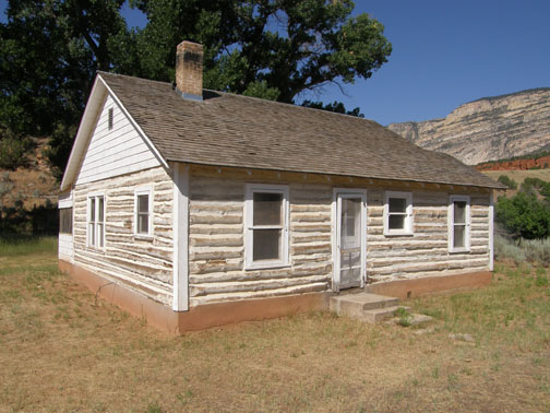
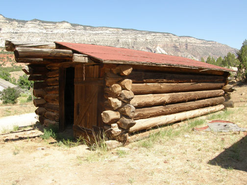
- Upper Wade and Curtis Cabin
-
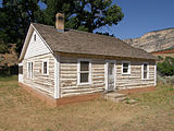
Rial Chew Ranch Complex Cabin
-

Rial Chew Ranch Complex Garage
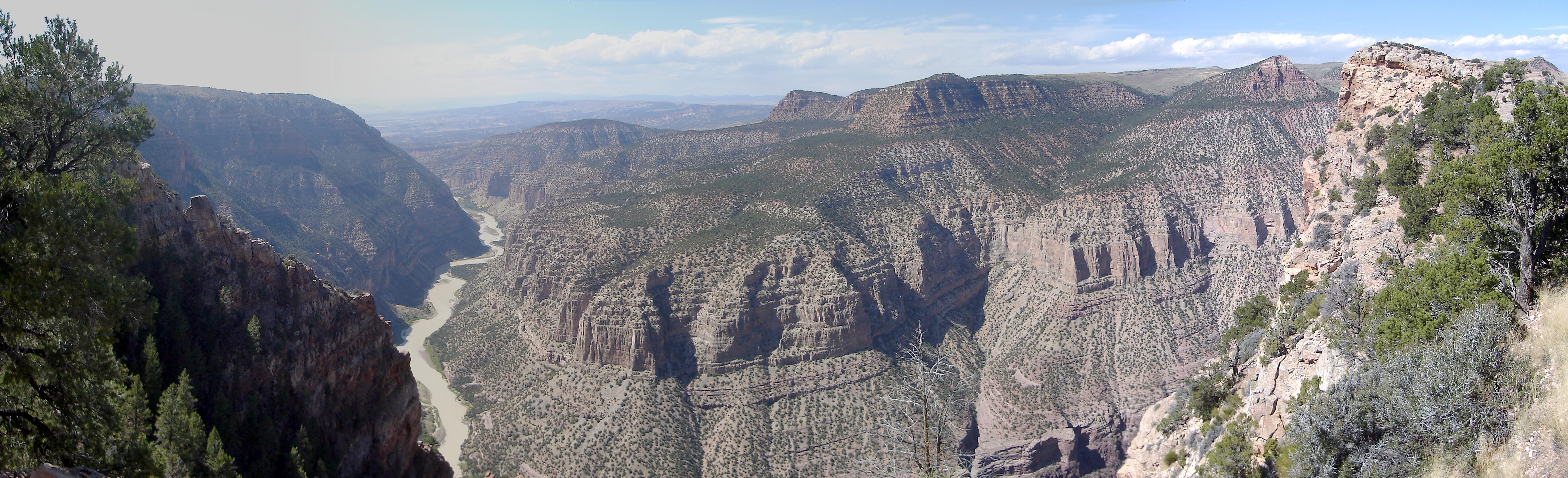
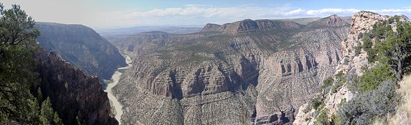 Green River Canyon in Dinosaur National Monument
In popular culture
In the October 2009 issue of Dark Avengers by Marvel Comics, Dinosaur, CO is the site of a portal that consumes Norman Osborn's Dark Avengers.
See also
- Colorado municipalities
- Dinosaur National Monument
- Prehistory of Colorado
References
- ^ a b "Active Colorado Municipalities". State of Colorado, Department of Local Affairs. http://www.dola.state.co.us/dlg/local_governments/municipalities.html. Retrieved 2007-09-01.
- ^ "Colorado Municipal Incorporations". State of Colorado, Department of Personnel & Administration, Colorado State Archives. 2004-12-01. http://www.colorado.gov/dpa/doit/archives/muninc.html. Retrieved 2007-09-02.
- ^ "US Board on Geographic Names". United States Geological Survey. 2007-10-25. http://geonames.usgs.gov. Retrieved 2008-01-31.
- ^ "ZIP Code Lookup" (JavaScript/HTML). United States Postal Service. http://zip4.usps.com/zip4/citytown.jsp. Retrieved September 8, 2007.
- ^ "Dinosaur". Colorado Tourism Office. 2010. http://www.colorado.com/Dinosaur.aspx. Retrieved 2010-05-30.
- ^ "US Gazetteer files: 2010, 2000, and 1990". United States Census Bureau. 2011-02-12. http://www.census.gov/geo/www/gazetteer/gazette.html. Retrieved 2011-04-23.
- ^ "Dinosaur, Colorado". www.dinosaurdiamond.org. http://www.dinosaurdiamond.org/Attract_Historic.htm. Retrieved 2010-05-30.
- ^ "Key to the City: Dinosaur". usacitiesonline.com. http://www.usacitiesonline.com/cocountydinosaur.htm. Retrieved 2010-05-30.
- ^ "American FactFinder". United States Census Bureau. http://factfinder.census.gov. Retrieved 2008-01-31.
- ^ National Register of Historic Places in Moffat County American Dreams, Inc. Retrieved 2011-10-6.
External links
Municipalities and communities of Moffat County, Colorado City 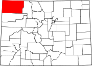
Town Dinosaur
Unincorporated
communitiesElk Springs | Hamilton | Maybell | Slater
Protected Areas of the State of Colorado Federal National ParksNational MonumentsNational Recreation AreasNational Historic SitesNational Historic TrailsOld Spanish Trail · Pony Express Trail · Santa Fe TrailNational Scenic TrailContinental Divide TrailArapaho · Grand Mesa · Gunnison · Pike · Rio Grande · Roosevelt · Routt · San Isabel · San Juan · Uncompahgre · White RiverNational WildernessBlack Canyon of the Gunnison · Black Ridge Canyons · Buffalo Peaks · Byers Peak · Cache La Poudre · Collegiate Peaks · Comanche Peak · Dominguez · Eagles Nest · Flat Tops · Fossil Ridge · Great Sand Dunes · Greenhorn Mountain · Gunnison Gorge · Holy Cross · Hunter-Fryingpan · Indian Peaks · James Peak · La Garita · Lizard Head · Lost Creek · Maroon Bells-Snowmass · Mesa Verde · Mount Evans · Mount Massive · Mount Sneffels · Mount Zirkel · Neota · Never Summer · Platte River · Powderhorn · Ptarmigan Peak · Raggeds · Rawah · Sangre de Cristo · Sarvis Creek · South San Juan · Spanish Peaks · Uncompahgre · Vasquez Peak · Weminuche · West ElkNational Conservation AreasNational Wildlife RefugesAlamosa · Arapaho · Baca · Browns Park · Monte Vista · Rocky Flats · Rocky Mountain Arsenal · Two PondsState Arkansas Headwaters · Barr Lake · Bonny Lake · Boyd Lake · Castlewood Canyon · Chatfield · Cherry Creek · Cheyenne Mountain · Crawford · Eldorado Canyon · Eleven Mile · Golden Gate Canyon · Harvey Gap · Highline Lake · Jackson Lake · James M. Robb - Colorado River · John Martin Reservoir · Lake Pueblo · Lathrop · Lone Mesa · Lory · Mancos · Mueller · Navajo · North Sterling · Paonia · Pearl Lake · Ridgway · Rifle Falls · Rifle Gap · Roxborough · San Luis · Spinney Mountain · St. Vrain · Stagecoach · State Forest · Staunton · Steamboat Lake · Sweitzer Lake · Sylvan Lake · Trinidad Lake · Vega · Yampa RiverByers-Evans House · Colorado History Museum · El Pueblo · Fort Garland · Fort Vasquez · Georgetown Loop · Healy House Museum and Dexter Cabin · Pearce-McAllister Cottage · Pike Stockade · Trinidad History Museum · Ute Indian MuseumOther Beaver Meadows · Burlington Carousel · Black Hawk · Central City · Colorado Chautauqua · Cripple Creek · Durango-Silverton Railroad · Georgetown · Granada · Leadville · Lindenmeier Site · Lowry Ruin · Mesa Verde · Pikes Peak · Pike's Stockade · Raton Pass · Shenandoah-Dives Mill · Silver Plume · Silverton · Telluride · U.S. Air Force Academy Cadet AreaGarden of the Gods · Garden Park Fossil Area · Indian Springs Trace Fossil · Lost Creek Scenic Area · Morrison Fossil Area · Raton Mesa · Roxborough Park · Russell Lakes · Sand Creek · Slumgullion Earthflow · Spanish Peaks · Summit LakeAmerican Discovery Trail · Colorado Trail · Continental Divide Trail · Great Divide Trail · Kokopelli's Trail · Paradox Trail · Tabeguache TrailAlpine Loop · Cache la Poudre-North Park · Colorado River Headwaters · Dinosaur Diamond · Flat Tops · Frontier Pathways · Gold Belt · Grand Mesa · Guanella Pass · Highway of Legends · Lariat Loop · Los Caminos Antiguos · Mount Evans · Pawnee Pioneer · Peak to Peak · San Juan Skyway · Santa Fe Trail · Silver Thread · South Platte River Trail · Top of the Rockies · Trail of the Ancients · Trail Ridge · Unaweep/Tabeguache · West Elk LoopCategories:- Populated places in Moffat County, Colorado
- Towns in Colorado
- Prehistoric sites


Wikimedia Foundation. 2010.