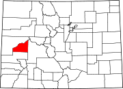
- Delta, Colorado
-
City of Delta, Colorado — City — Main Street Nickname(s): City of Murals Location in Delta County and the State of Colorado Coordinates: 38°44′27″N 108°3′48″W / 38.74083°N 108.06333°WCoordinates: 38°44′27″N 108°3′48″W / 38.74083°N 108.06333°W Country  United States
State  State of Colorado
County Delta County Seat[1] Incorporated October 24, 1882[2] Government – Type Home Rule Municipality[1] – Mayor Mary Cooper – Mayor Pro-Tem Guy Pfalzgraff Area – Total 5.5 sq mi (14.3 km2) – Land 5.3 sq mi (14.1 km2) – Water 0.2 sq mi (0.5 km2) 3.49% Elevation 4,953 ft (1,486 m) Population (2010) – Total 8,915 – Density 1,682.08/sq mi (632.27/km2) Time zone MST (UTC-7) – Summer (DST) MDT (UTC-6) ZIP code[3] 81416 Area code(s) 970 FIPS code 08-19850 GNIS feature ID 0185516 Website City of Delta The City of Delta is the county seat and the most populous city of Delta County, Colorado, United States.[4] The population was 8,915 at the 2010 census. The United States Forest Service headquarters of the Grand Mesa, Gunnison, and Uncompahgre National Forests are located in Delta.
Contents
Geography
Delta is located at 38°44′27″N 108°3′48″W / 38.74083°N 108.06333°W (38.740879, -108.063423)[5].
According to the United States Census Bureau, the city has a total area of 5.5 square miles (14 km2), of which, 5.3 square miles (14 km2) of it is land and 0.2 square miles (0.52 km2) of it (3.62%) is water.
Demographics
As of the census[6] of 2010, there were 8,915 people, 3,530 households, and 2,337 families residing in the city. The population density was 1,682.1 people per square mile (632.3/km²). There were 3,825 housing units at an average density of 721.7 per square mile (271.3/km²). The racial makeup of the city was 82.2% White, 0.2% African American, 1.1% Native American, 0.7% Asian, 12.5% from other races, and 3.1% from two or more races. Hispanic or Latino of any race were 26.1% of the population.
There were 3,530 households out of which 30.3% had children under the age of 18 living with them, 49.3% were married couples living together, 11.6% had a female householder with no husband present, and 33.8% were non-families. 30.0% of all households were made up of individuals and 14.8% had someone living alone who was 65 years of age or older. The average household size was 2.49, and the average family size was 3.08.
In the city the population was spread out with 26.7% under the age of 18, 8.2% from 18 to 24, 23.2% from 25 to 44, 24.5% from 45 to 64, and 17.5% who were 65 years of age or older. The median age was 38.0 years. For every 100 females there were 93.8 males. For every 100 females age 18 and over, there were 91.0 males.
Historical populations Census Pop. %± 2010 8,915 — Transportation
Montrose Regional Airport, located 21 miles south of Delta, is the closest airport served by scheduled airlines. In Grand Junction, which is 39 miles to the north, there are also scheduled airline services, as well as an Amtrak train station with a daily California Zephyr departure on each direction.
Major Highways
 U.S. Highway 50 runs east-west, crossing 12 states. It links Sacramento, California with Ocean City, Maryland. In Colorado, it connects Delta to Montrose, Grand Junction and Pueblo.
 State Highway 65 is a 61-mile stretch that runs from State Highway 92 in Delta to Interstate 70 near Palisade.
 State Highway 92 begins in Delta, at the intersection of Main Street and First Street. It runs 73 miles to the east, reaching US 50 near Blue Mesa Reservoir and Curecanti National Recreation Area.
Media
The principal newspaper is the Delta County Independent, which is published weekly on Wednesdays. The High Country Shopper, a free shopper paper that distributes over 15,000 papers throughout the county.
See also
- Old Spanish National Historic Trail
- Colorado municipalities
- Egyptian Theatre (Delta, Colorado)
References
- ^ a b "Active Colorado Municipalities". State of Colorado, Department of Local Affairs. http://www.dola.state.co.us/dlg/local_governments/municipalities.html. Retrieved 2007-12-01.
- ^ "Colorado Municipal Incorporations". State of Colorado, Department of Personnel & Administration, Colorado State Archives. 2004-12-01. http://www.colorado.gov/dpa/doit/archives/muninc.html. Retrieved 2007-09-02.
- ^ "ZIP Code Lookup" (JavaScript/HTML). United States Postal Service. http://zip4.usps.com/zip4/citytown.jsp. Retrieved September 6, 2007.
- ^ "Find a County". National Association of Counties. http://www.naco.org/Counties/Pages/FindACounty.aspx. Retrieved 2011-06-07.
- ^ "US Gazetteer files: 2010, 2000, and 1990". United States Census Bureau. 2011-02-12. http://www.census.gov/geo/www/gazetteer/gazette.html. Retrieved 2011-04-23.
- ^ "American FactFinder". United States Census Bureau. http://factfinder.census.gov. Retrieved 2008-01-31.
Further reading
- Borowsky, Larry and Cleary, Brooke (2002) "Delta's King of Kings: The Egyptian Theatre and the Bank Night Craze" Colorado Heritage Summer 2002: pp. 2–15
- Ferguson, Olivia Spalding (1928) "A Sketch of Delta County History" The Colorado Magazine 5 (October 1928): pp. 161–164
External links
- City of Delta website
- CDOT map of the City of Delta
- Delta Area Chamber of Commerce
- Delta County Independent
- Delta Real Time Weather
Municipalities and communities of Delta County, Colorado City Delta
Towns Cedaredge | Crawford | Hotchkiss | Orchard City | Paonia
Unincorporated
communitiesCategories:- Populated places in Delta County, Colorado
- Cities in Colorado
- County seats in Colorado
Wikimedia Foundation. 2010.


