- Maybell, Colorado
-
Maybell, Colorado — Town — Location in Moffat County and the state of Colorado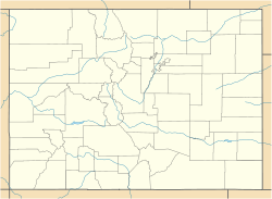

Coordinates: 40°31′02″N 108°05′10″W / 40.51722°N 108.08611°WCoordinates: 40°31′02″N 108°05′10″W / 40.51722°N 108.08611°W Country  United States
State  Colorado
County Moffat[1] Elevation[1] 5,922 ft (1,805 m) Time zone MST (UTC-7) - Summer (DST) MDT (UTC-6) ZIP code[2] 81640 Area code(s) 970 GNIS feature ID 0170708 Maybell is an unincorporated town and a U.S. Post Office in Moffat County, Colorado, United States. The Maybell Post Office has the ZIP Code 81640.[2]
The lowest temperature ever recorded in the state of Colorado was -61°F (-52°C) at Maybell on February 1, 1985.[3]
Geography
Maybell is located at 40°31′02″N 108°05′10″W / 40.51722°N 108.08611°W (40.517192,-108.086071).
References
- ^ a b "US Board on Geographic Names". United States Geological Survey. 2007-10-25. http://geonames.usgs.gov. Retrieved 2008-01-31.
- ^ a b "ZIP Code Lookup" (JavaScript/HTML). United States Postal Service. 2007-01-11. http://zip4.usps.com/zip4/citytown.jsp. Retrieved 2007-01-11.
- ^ "Record Lowest Temperatures by State" (PDF). National Climatic Data Center. 2004-01-01. http://lwf.ncdc.noaa.gov/oa/pub/data/special/mintemps.pdf. Retrieved 2007-01-11.
Municipalities and communities of Moffat County, Colorado County seat: Craig City 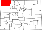
Town Unincorporated
communitiesElk Springs | Hamilton | Maybell | Slater
Categories:- Populated places in Moffat County, Colorado
- Unincorporated communities in Colorado


Wikimedia Foundation. 2010.