Nebraska census statistical areas
- Nebraska census statistical areas
-
The United States Census Bureau has defined two Combined Statistical Areas (CSAs),[1] three Metropolitan Statistical Areas (MSAs),[2] and ten Micropolitan Statistical Areas (μSAs)[3] in the State of Nebraska. The following table describes these areas with the following information:
- The name of the Combined Statistical Area (CSA), if any.[1][4]
- The population of the CSA as of 2006-07-01, as estimated by the United States Census Bureau.[5][6]
- The name of the Core Based Statistical Area (CBSA).[7][4]
- The population of the CBSA as of 2006-07-01, as estimated by the United States Census Bureau.[8][6]
- The name of the county.[4]
- The population of the county as of 2006-07-01, as estimated by the United States Census Bureau.[9][6]

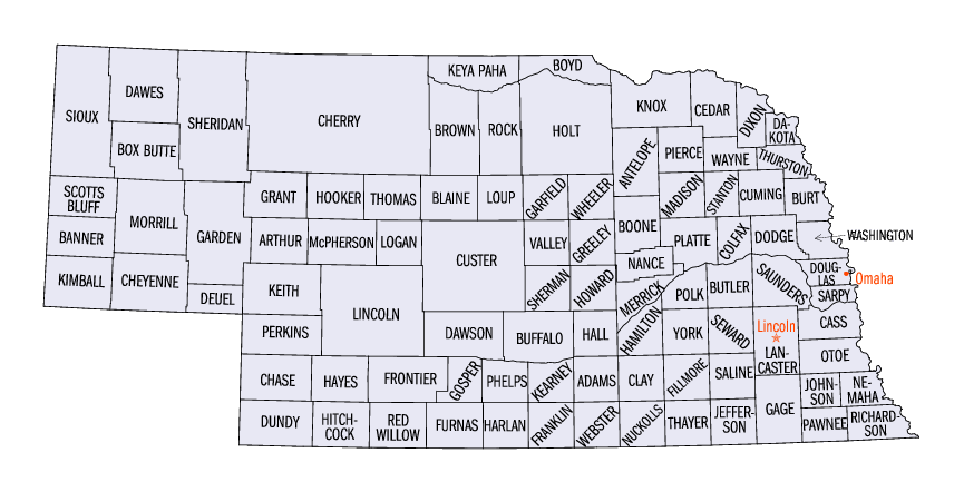
Map of the 93 counties of the State of Nebraska
United States Census Bureau Statistical Areas in the State of Nebraska
| Combined Statistical Area |
2006 Pop |
Core Based Statistical Area |
2006 Pop |
County |
2006 Pop |
| Omaha-Council Bluffs-Fremont, NE-IA CSA |
858,720
737,162 |
Omaha-Council Bluffs, NE-IA MSA |
822,549
700,991 |
Douglas County, Nebraska |
492,003 |
| Sarpy County, Nebraska |
142,637 |
| Pottawattamie County, Iowa |
90,218 |
| Cass County, Nebraska |
25,963 |
| Saunders County, Nebraska |
20,344 |
| Washington County, Nebraska |
20,044 |
| Harrison County, Iowa |
15,745 |
| Mills County, Iowa |
15,595 |
| Fremont, NE μSA |
36,171 |
Dodge County, Nebraska |
36,171 |
| primary census statistical area |
283,970 |
Lincoln, NE MSA |
283,970 |
Lancaster County, Nebraska |
267,135 |
| Seward County, Nebraska |
16,835 |
| primary census statistical area |
70,245 |
Grand Island, NE μSA |
70,245 |
Hall County, Nebraska |
55,555 |
| Merrick County, Nebraska |
7,954 |
| Howard County, Nebraska |
6,736 |
| primary census statistical area |
50,655 |
Kearney, NE μSA |
50,655 |
Buffalo County, Nebraska |
43,954 |
| Kearney County, Nebraska |
6,701 |
| primary census statistical area |
49,413 |
Norfolk, NE μSA |
49,413 |
Madison County, Nebraska |
35,279 |
| Pierce County, Nebraska |
7,564 |
| Stanton County, Nebraska |
6,570 |
| primary census statistical area |
39,749 |
Hastings, NE μSA |
39,749 |
Adams County, Nebraska |
33,185 |
| Clay County, Nebraska |
6,564 |
| primary census statistical area |
37,329 |
Scottsbluff, NE μSA |
37,329 |
Scotts Bluff County, Nebraska |
36,546 |
| Banner County, Nebraska |
783 |
| primary census statistical area |
37,111 |
North Platte, NE μSA |
37,111 |
Lincoln County, Nebraska |
35,865 |
| Logan County, Nebraska |
749 |
| McPherson County, Nebraska |
497 |
| primary census statistical area |
31,962 |
Columbus, NE μSA |
31,962 |
Platte County, Nebraska |
31,962 |
| primary census statistical area |
26,996 |
Lexington, NE μSA |
26,996 |
Dawson County, Nebraska |
25,018 |
| Gosper County, Nebraska |
1,978 |
| Sioux City-Vermillion, IA-NE-SD CSA |
156,341
26,757 |
Sioux City, IA-NE-SD MSA |
143,474
26,757 |
Woodbury County, Iowa |
102,972 |
| Dakota County, Nebraska |
20,587 |
| Union County, South Dakota |
13,745 |
| Dixon County, Nebraska |
6,170 |
| Vermillion, SD μSA |
12,867 |
Clay County, South Dakota |
12,867 |
| primary census statistical area |
23,365 |
Beatrice, NE μSA |
23,365 |
Gage County, Nebraska |
23,365 |
| none |
Otoe County, Nebraska |
15,747 |
| York County, Nebraska |
14,502 |
| Saline County, Nebraska |
14,155 |
| Custer County, Nebraska |
11,242 |
| Box Butte County, Nebraska |
11,132 |
| Red Willow County, Nebraska |
10,865 |
| Holt County, Nebraska |
10,610 |
| Colfax County, Nebraska |
10,113 |
| Cheyenne County, Nebraska |
9,865 |
| Cuming County, Nebraska |
9,660 |
| Hamilton County, Nebraska |
9,490 |
| Phelps County, Nebraska |
9,442 |
| Wayne County, Nebraska |
9,196 |
| Cedar County, Nebraska |
8,819 |
| Knox County, Nebraska |
8,812 |
| Richardson County, Nebraska |
8,656 |
| Butler County, Nebraska |
8,595 |
| Dawes County, Nebraska |
8,466 |
| Keith County, Nebraska |
8,250 |
| Jefferson County, Nebraska |
7,874 |
| Burt County, Nebraska |
7,341 |
| Thurston County, Nebraska |
7,273 |
| Nemaha County, Nebraska |
7,247 |
| Antelope County, Nebraska |
6,931 |
| Fillmore County, Nebraska |
6,259 |
| Cherry County, Nebraska |
5,934 |
| Boone County, Nebraska |
5,668 |
| Sheridan County, Nebraska |
5,571 |
| Polk County, Nebraska |
5,349 |
| Thayer County, Nebraska |
5,317 |
| Morrill County, Nebraska |
5,171 |
| Furnas County, Nebraska |
5,003 |
| Johnson County, Nebraska |
4,683 |
| Nuckolls County, Nebraska |
4,650 |
| Valley County, Nebraska |
4,373 |
| Chase County, Nebraska |
3,811 |
| Kimball County, Nebraska |
3,710 |
| Nance County, Nebraska |
3,705 |
| Webster County, Nebraska |
3,701 |
| Harlan County, Nebraska |
3,446 |
| Brown County, Nebraska |
3,354 |
| Franklin County, Nebraska |
3,348 |
| Sherman County, Nebraska |
3,083 |
| Perkins County, Nebraska |
2,992 |
| Hitchcock County, Nebraska |
2,926 |
| Pawnee County, Nebraska |
2,804 |
| Frontier County, Nebraska |
2,729 |
| Greeley County, Nebraska |
2,454 |
| Boyd County, Nebraska |
2,185 |
| Dundy County, Nebraska |
2,109 |
| Garden County, Nebraska |
1,995 |
| Deuel County, Nebraska |
1,958 |
| Garfield County, Nebraska |
1,790 |
| Rock County, Nebraska |
1,544 |
| Sioux County, Nebraska |
1,403 |
| Hayes County, Nebraska |
1,029 |
| Keya Paha County, Nebraska |
892 |
| Wheeler County, Nebraska |
823 |
| Hooker County, Nebraska |
756 |
| Grant County, Nebraska |
660 |
| Loup County, Nebraska |
656 |
| Thomas County, Nebraska |
629 |
| Blaine County, Nebraska |
492 |
| Arthur County, Nebraska |
372 |
See also
United States census statistical areas by state, district, or territory
NE
AS
MP
GU
VI
- State of Nebraska
- Demographics of Nebraska
- Geography of Nebraska
- United States
References
- ^ a b The United States Census Bureau defines a Combined Statistical Area (CSA) as an aggregate of adjacent Core Based Statistical Areas that are linked by commuting ties.
- ^ The United States Census Bureau defines a Metropolitan Statistical Area (MSA) as a Core Based Statistical Area having at least one urbanized area of 50,000 or more population, plus adjacent territory that has a high degree of social and economic integration with the core as measured by commuting ties.
- ^ The United States Census Bureau defines a Micropolitan Statistical Area (μSA) as a Core Based Statistical Area having at least one urban cluster of at least 10,000 but less than 50,000 population, plus adjacent territory that has a high degree of social and economic integration with the core as measured by commuting ties.
- ^ a b c An area that extends into more than one state is displayed in teal. An out-of-state area is displayed in green.
- ^ "Annual Estimates of the Population of Combined Statistical Areas: April 1, 2000 to July 1, 2006 (CBSA-EST2006-02)" (CSV). 2006 Population Estimates. United States Census Bureau, Population Division. 2007-04-05. http://www.census.gov/population/www/estimates/metro_general/2006/CBSA-EST2006-02.csv. Retrieved 2007-04-08.
- ^ a b c The total population of a multi-state area is displayed in teal, with the in-state population displayed below in black. The population of an out-of-state area is displayed in green.
- ^ The United States Census Bureau defines a Core Based Statistical Area (CBSA) as one or more adjacent counties or county equivalents that have at least one urban cluster of at least 10,000 population, plus adjacent territory that has a high degree of social and economic integration with the core as measured by commuting ties. The Census Bureau has defined two types of CBSAs: (1) a Metropolitan Statistical Area (MSA), which has an urban core population of 50,000 or more, or (2) a Micropolitan Statistical Area (μSA), which has an urban core population of 10,000 or more but less than 50,000.
- ^ "Annual Estimates of the Population of Metropolitan and Micropolitan Statistical Areas: April 1, 2000 to July 1, 2006 (CBSA-EST2006-01)" (CSV). 2006 Population Estimates. United States Census Bureau, Population Division. 2007-04-05. http://www.census.gov/population/www/estimates/metro_general/2006/CBSA-EST2006-01.csv. Retrieved 2007-04-08.
- ^ "Annual County Population Estimates and Estimated Components of Change: April 1, 2000 to July 1, 2006 (CO-EST2006-alldata)" (CSV). 2006 Population Estimates. United States Census Bureau, Population Division. 2007-03-22. http://www.census.gov/popest/counties/files/CO-EST2006-ALLDATA.csv. Retrieved 2007-04-08.
External links
Categories:
- Metropolitan areas of Nebraska
- Micropolitan areas of Nebraska
- Census statistical areas
- Nebraska-related lists
Wikimedia Foundation.
2010.
Look at other dictionaries:
Highest-income metropolitan statistical areas in the United States — Income in the United States Affluence in the United States Household income in the United States Income inequality in the United States Personal income in the United States Social class in the United States Income by: State (localities by state)… … Wikipedia
List of Nebraska-related topics — This is a list of topics related to the U.S. State of Nebraska. NOTOC compactTOC4 0–9*37th State to join the United States of AmericaA*Adjacent states: **State of Colorado **State of Iowa **State of Kansas **State of Missouri **State of South… … Wikipedia
Norfolk Micropolitan Statistical Area — Map of Nebraska highlighting the Norfolk Micropolitan Statistical Area. The Norfolk Micropolitan Statistical Area, as defined by the United States Census Bureau, is an area consisting of three counties in Nebraska, anchored by the city of Norfolk … Wikipedia
North Platte Micropolitan Statistical Area — Map of Nebraska highlighting the North Platte Micropolitan Statistical Area. The North Platte Micropolitan Statistical Area, as defined by the United States Census Bureau, is an area consisting of three counties in Nebraska, anchored by the city… … Wikipedia
Scottsbluff Micropolitan Statistical Area — The Scottsbluff Micropolitan Statistical Area, as defined by the United States Census Bureau, is an area consisting of two counties in Nebraska, anchored by the city of Scottsbluff.As of the 2000 census, the μSA had a population of 37,770 (though … Wikipedia
Grand Island Micropolitan Statistical Area — The Grand Island Micropolitan Statistical Area, as defined by the United States Census Bureau, is an area consisting of three counties in Nebraska, anchored by the city of Grand Island.As of the 2000 census, the μSA had a population of 68,305… … Wikipedia
Hastings Micropolitan Statistical Area — The Hastings Micropolitan Statistical Area, as defined by the United States Census Bureau, is an area consisting of two counties in Nebraska, anchored by the city of Hastings.As of the 2000 census, the μSA had a population of 38,190 (though a… … Wikipedia
Kearney Micropolitan Statistical Area — The Kearney Micropolitan Statistical Area, as defined by the United States Census Bureau, is an area consisting of two counties in Nebraska, anchored by the city of Kearney.As of the 2000 census, the area had a population of 49,141 (though a July … Wikipedia
Lexington Micropolitan Statistical Area — The Lexington Micropolitan Statistical Area, as defined by the United States Census Bureau, is an area consisting of two counties in Nebraska, anchored by the city of Lexington.As of the 2000 census, the μSA had a population of 26,508 (though a… … Wikipedia
Omaha, Nebraska — Omaha redirects here. For other uses, see Omaha (disambiguation). Omaha City An aerial view of Downtown Omaha from the ea … Wikipedia

 United States census statistical areas by state, district, or territoryNEASMPGUVI