- North Platte Micropolitan Statistical Area
-
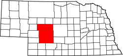 Map of Nebraska highlighting the North Platte Micropolitan Statistical Area.
The North Platte Micropolitan Statistical Area, as defined by the United States Census Bureau, is an area consisting of three counties in Nebraska, anchored by the city of North Platte.
As of the 2000 census, the μSA had a population of 35,939 (though a July 1, 2009 estimate placed the population at 36,890).[1]
Contents
Counties
Communities
- Brady
- Gandy
- Hershey
- Maxwell
- North Platte (Principal City)
- Ringgold (unincorporated)
- Stapleton
- Sutherland
- Tryon (unincorporated)
- Wallace
- Wellfleet
Demographics
As of the census[2] of 2000, there were 35,939 people, 14,594 households, and 9,830 families residing within the μSA. The racial makeup of the μSA was 94.83% White, 0.53% African American, 0.51% Native American, 0.36% Asian, 0.02% Pacific Islander, 2.58% from other races, and 1.17% from two or more races. Hispanic or Latino of any race were 5.27% of the population.
The median income for a household in the μSA was $31,814, and the median income for a family was $38,464. Males had a median income of $29,229 versus $17,517 for females. The per capita income for the μSA was $15,563.
See also
References
- ^ "Table 1. Annual Estimates of the Population of Metropolitan and Micropolitan Statistical Areas: April 1, 2000 to July 1, 2009 (CBSA-EST2009-01)" (CSV). 2009 Population Estimates. United States Census Bureau, Population Division. 2010-03-23. http://www.census.gov/popest/metro/tables/2009/CBSA-EST2009-01.csv. Retrieved 2010-03-26.
- ^ "American FactFinder". United States Census Bureau. http://factfinder.census.gov. Retrieved 2008-01-31.
Categories:- North Platte micropolitan area
- Lincoln County, Nebraska
- Logan County, Nebraska
- McPherson County, Nebraska
- Dawes County, Nebraska

Wikimedia Foundation. 2010.