- Dawson County, Nebraska
-
Dawson County, Nebraska 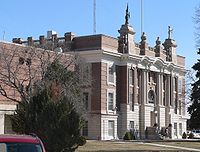 Dawson County Courthouse in Lexington
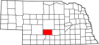
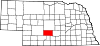
Location in the state of Nebraska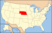
Nebraska's location in the U.S.Founded 1871 Named for Jacob Dawson Seat Lexington Largest city Lexington Area
- Total
- Land
- Water
1,019 sq mi (2,640 km²)
1,013 sq mi (2,623 km²)
6 sq mi (16 km²), 0.62%Population
- (2010)
- Density
24,326
24/sq mi (9/km²)Time zone Central: UTC-6/-5 Website http://www.dawsoncountyne.net/ Dawson County is a county located in the U.S. state of Nebraska. As of 2010, the population was 24,326. Its county seat is Lexington.[1]
Dawson County is part of the Lexington, Nebraska, Micropolitan Statistical Area.
In the Nebraska license plate system, Dawson County is represented by the prefix 18 (it had the eighteenth-largest number of vehicles registered in the county when the license plate system was established in 1922).
Contents
Geography
According to the U.S. Census Bureau, the county has a total area of 1,019 square miles (2,639.2 km2), of which 1,013 square miles (2,623.7 km2) is land and 6 square miles (15.5 km2) (0.62%) is water.
Major highways
 Interstate 80
 U.S. Highway 30
 U.S. Highway 283
 Nebraska Highway 21
 Nebraska Highway 23
 Nebraska Highway 40
 Nebraska Highway 47
Adjacent counties
- Buffalo County, Nebraska - (East)
- Phelps County, Nebraska - (Southeast)
- Gosper County, Nebraska - (South)
- Frontier County, Nebraska - (Southwest)
- Lincoln County, Nebraska - (West)
- Custer County, Nebraska - (North)

Custer County Lincoln County 
Buffalo County  Dawson County, Nebraska

Frontier County Gosper County Phelps County History
Dawson County was formed in 1860. Sources differ on the origin of its name: some hold that it was named after a Democratic Pennsylvania Congressman, John Littleton Dawson,[2] while others believe that it was named after Jacob Dawson, an early Nebraska settler.[3]
Demographics
Historical populations Census Pop. %± 1860 16 — 1870 103 543.8% 1880 2,909 2,724.3% 1890 10,129 248.2% 1900 12,264 21.1% 1910 15,961 30.1% 1920 16,004 0.3% 1930 17,875 11.7% 1940 17,890 0.1% 1950 19,393 8.4% 1960 19,405 0.1% 1970 19,771 1.9% 1980 22,304 12.8% 1990 19,940 −10.6% 2000 24,365 22.2% 2010 24,326 −0.2% As of the census[4] of 2000, there were 24,365 people, 8,824 households, and 6,273 families residing in the county. The population density was 24 people per square mile (9/km²). There were 9,805 housing units at an average density of 10 per square mile (4/km²). The racial makeup of the county was 82.32% White, 0.31% Black or African American, 0.67% Native American, 0.66% Asian, 0.01% Pacific Islander, 14.49% from other races, and 1.53% from two or more races. 25.36% of the population were Hispanic or Latino of any race. 32.0% were of German, 6.7% American, 6.7% Irish and 6.4% English ancestry according to Census 2000.
There were 8,824 households out of which 35.80% had children under the age of 18 living with them, 58.80% were married couples living together, 7.90% had a female householder with no husband present, and 28.90% were non-families. 24.60% of all households were made up of individuals and 12.00% had someone living alone who was 65 years of age or older. The average household size was 2.71 and the average family size was 3.21.
In the county the population was spread out with 29.20% under the age of 18, 8.40% from 18 to 24, 27.60% from 25 to 44, 20.70% from 45 to 64, and 14.10% who were 65 years of age or older. The median age was 34 years. For every 100 females there were 101.70 males. For every 100 females age 18 and over, there were 100.90 males.
The median income for a household in the county was $36,132, and the median income for a family was $42,224. Males had a median income of $26,865 versus $20,569 for females. The per capita income for the county was $15,973. About 8.60% of families and 10.80% of the population were below the poverty line, including 14.20% of those under age 18 and 9.20% of those age 65 or over.
Communities
Cities
Villages
Other place
See also
References
- ^ "Find a County". National Association of Counties. http://www.naco.org/Counties/Pages/FindACounty.aspx. Retrieved 2011-06-07.
- ^ "Dawson, John L." Nebraska State Historical Society. Retrieved 2011-09-09.
- ^ Fitzpatrick, Lilian Linder (1925). "Nebraska Place-Names". University of Nebraska Department of English. Retrieved 2011-09-09.
- ^ "American FactFinder". United States Census Bureau. http://factfinder.census.gov. Retrieved 2008-01-31.
Municipalities and communities of Dawson County, Nebraska Cities Cozad | Gothenburg | Lexington
Villages Unincorporated
communitiesCategories:- Nebraska counties
- Dawson County, Nebraska
- Lexington micropolitan area


Wikimedia Foundation. 2010.