Massachusetts census statistical areas
- Massachusetts census statistical areas
-
The United States Census Bureau has defined one Combined Statistical Area (CSA)[1] and six Metropolitan Statistical Areas (MSAs)[2] in the Commonwealth of Massachusetts. The following table describes these areas with the following information:
- The name of the Combined Statistical Area (CSA), if any.[1][3]
- The population of the CSA as of 2006-07-01, as estimated by the United States Census Bureau.[4][5]
- The name of the Core Based Statistical Area (CBSA).[6][3]
- The population of the CBSA as of 2006-07-01, as estimated by the United States Census Bureau.[7][5]
- The name of the county.[3]
- The population of the county as of 2006-07-01, as estimated by the United States Census Bureau.[8][5]

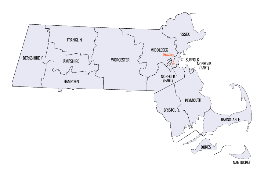
Map of the 14 counties of the Commonwealth of Massachusetts
United States Census Bureau Statistical Areas in the Commonwealth of Massachusetts
| Combined Statistical Area |
2006 Pop |
Core Based Statistical Area |
2006 Pop |
County |
2006 Pop |
| Boston-Worcester-Manchester, MA-RI-NH CSA |
7,465,634
5,369,331 |
Boston-Cambridge-Quincy, MA-NH MSA |
4,455,217
4,038,960 |
Middlesex County, Massachusetts |
1,467,016 |
| Essex County, Massachusetts |
735,958 |
| Suffolk County, Massachusetts |
687,610 |
| Norfolk County, Massachusetts |
654,753 |
| Plymouth County, Massachusetts |
493,623 |
| Rockingham County, New Hampshire |
296,267 |
| Strafford County, New Hampshire |
119,990 |
| Providence-New Bedford-Fall River, RI-MA MSA |
1,612,989
545,379 |
Providence County, Rhode Island |
635,596 |
| Bristol County, Massachusetts |
545,379 |
| Kent County, Rhode Island |
170,053 |
| Washington County, Rhode Island |
127,561 |
| Newport County, Rhode Island |
82,144 |
| Bristol County, Rhode Island |
52,256 |
| Worcester, MA MSA |
784,992 |
Worcester County, Massachusetts |
784,992 |
| Manchester-Nashua, NH MSA |
402,789 |
Hillsborough County, New Hampshire |
402,789 |
| Concord, NH μSA |
148,085 |
Merrimack County, New Hampshire |
148,085 |
| Laconia, NH μSA |
61,562 |
Belknap County, New Hampshire |
61,562 |
| primary census statistical area |
686,174 |
Springfield, MA MSA |
686,174 |
Hampden County, Massachusetts |
460,520 |
| Hampshire County, Massachusetts |
153,471 |
| Franklin County, Massachusetts |
72,183 |
| primary census statistical area |
224,816 |
Barnstable Town, MA MSA |
224,816 |
Barnstable County, Massachusetts |
224,816 |
| primary census statistical area |
131,117 |
Pittsfield, MA MSA |
131,117 |
Berkshire County, Massachusetts |
131,117 |
| none |
Dukes County, Massachusetts |
15,515 |
| Nantucket County, Massachusetts |
10,240 |
See also
United States census statistical areas by state, district, or territory
MA
AS
MP
GU
VI
References
- ^ a b The United States Census Bureau defines a Combined Statistical Area (CSA) as an aggregate of adjacent Core Based Statistical Areas that are linked by commuting ties.
- ^ The United States Census Bureau defines a Metropolitan Statistical Area (MSA) as a Core Based Statistical Area having at least one urbanized area of 50,000 or more population, plus adjacent territory that has a high degree of social and economic integration with the core as measured by commuting ties.
- ^ a b c An area that extends into more than one state is displayed in teal. An out-of-state area is displayed in green.
- ^ "Annual Estimates of the Population of Combined Statistical Areas: April 1, 2000 to July 1, 2006 (CBSA-EST2006-02)" (CSV). 2006 Population Estimates. United States Census Bureau, Population Division. 2007-04-05. http://www.census.gov/population/www/estimates/metro_general/2006/CBSA-EST2006-02.csv. Retrieved 2007-04-07.
- ^ a b c The total population of a multi-state area is displayed in teal, with the in-state population displayed below in black. The population of an out-of-state area is displayed in green.
- ^ The United States Census Bureau defines a Core Based Statistical Area (CBSA) as one or more adjacent counties or county equivalents that have at least one urban cluster of at least 10,000 population, plus adjacent territory that has a high degree of social and economic integration with the core as measured by commuting ties. The Census Bureau has defined two types of CBSAs: (1) a Metropolitan Statistical Area (MSA), which has an urban core population of 50,000 or more, or (2) a Micropolitan Statistical Area (μSA), which has an urban core population of 10,000 or more but less than 50,000.
- ^ "Annual Estimates of the Population of Metropolitan and Micropolitan Statistical Areas: April 1, 2000 to July 1, 2006 (CBSA-EST2006-01)" (CSV). 2006 Population Estimates. United States Census Bureau, Population Division. 2007-04-05. http://www.census.gov/population/www/estimates/metro_general/2006/CBSA-EST2006-01.csv. Retrieved 2007-04-07.
- ^ "Annual County Population Estimates and Estimated Components of Change: April 1, 2000 to July 1, 2006 (CO-EST2006-alldata)" (CSV). 2006 Population Estimates. United States Census Bureau, Population Division. 2007-03-22. http://www.census.gov/popest/counties/files/CO-EST2006-ALLDATA.csv. Retrieved 2007-04-07.
External links
Categories:
- Metropolitan areas of Massachusetts
- Census statistical areas
- Massachusetts-related lists
Wikimedia Foundation.
2010.
Look at other dictionaries:
New Hampshire census statistical areas — Map of the ten counties of the State of New Hampshire The United States Census Bureau has defined two Combined Statistical Areas (CSAs),[1] two Metropolitan Statistical Areas (MSAs) … Wikipedia
Highest-income metropolitan statistical areas in the United States — Income in the United States Affluence in the United States Household income in the United States Income inequality in the United States Personal income in the United States Social class in the United States Income by: State (localities by state)… … Wikipedia
List of Massachusetts-related topics — The following is a list of topics about the United States Commonwealth of Massachusetts. NOTOC compactTOC4 0–9*6th State to ratify the Constitution of the United States of AmericaA [ 14 counties of the Commonwealth of Massachusetts] *Adjacent… … Wikipedia
Springfield, Massachusetts metropolitan area — The Springfield Metropolitan Area is the region that is socio economically tied to the city of Springfield, Massachusetts. The Office of Management and Budget defines the metropolitan statistical area (MSA) of Springfield as the region consisting … Wikipedia
Census-designated place — A census designated place (CDP) is a type of place (a concentration of population) identified by the United States Census Bureau for statistical purposes. CDPs are delineated for each decennial census as the statistical counterparts of… … Wikipedia
Massachusetts — This article is about the U.S. state. For other uses, see Massachusetts (disambiguation). Commonwealth of Massachusetts … Wikipedia
Census-designated place — Pour les articles homonymes, voir CDP. Aux États Unis, une census designated place (CDP), que l on peut traduire par « secteur statistique » ou, littéralement, « lieu désigné par recensement », est une zone délimitée par le… … Wikipédia en Français
Census — taker visits a family living in a caravan, Netherlands 1925 A census is the procedure of systematically acquiring and recording information about the members of a given population. It is a regularly occurring and official count of a particular… … Wikipedia
Massachusetts Bay Transportation Authority — The MBTA provides services in five different modes (boat not pictured) around Greater Boston … Wikipedia
Geography of Massachusetts — A portion of the north central Pioneer Valley near South Deerfield, much more rural than Springfield, in the southern part of the valley, or Boston, which is on the coast. Massachusetts, the 7th smallest state in the United States … Wikipedia

 United States census statistical areas by state, district, or territoryMAASMPGUVI