- Oregon census statistical areas
-
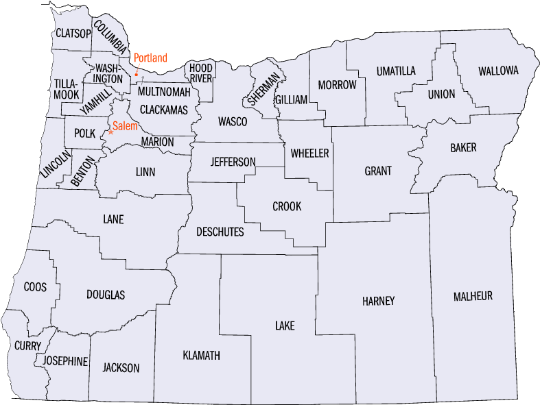
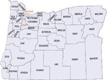 Map of the 36 counties of the State of Oregon
The United States Census Bureau has defined 2 Combined Statistical Areas (CSAs),[1] 6 Metropolitan Statistical Areas (MSAs),[2] and 13 Micropolitan Statistical Areas (μSAs)[3] in the State of Oregon. The following table describes these areas with the following information:
- The name of the Combined Statistical Area (CSA), if any.[1][4]
- The population of the CSA as of 2006-07-01, as estimated by the United States Census Bureau.[5][6]
- The name of the Core Based Statistical Area (CBSA).[7][4]
- The population of the CBSA as of 2006-07-01, as estimated by the United States Census Bureau.[8][6]
- The name of the county.[4]
- The population of the county as of 2006-07-01, as estimated by the United States Census Bureau.[9][6]
United States Census Bureau Statistical Areas in the State of Oregon Combined Statistical Area 2010 Pop Core Based Statistical Area 2010 Pop County 2010 Pop primary census statistical area 2,226,009
1,789,580Portland-Vancouver-Hillsboro, OR-WA MSA 2,226,009
1,789,580Multnomah County, Oregon 735,334 Washington County, Oregon 529,710 Clark County, Washington 425,363 Clackamas County, Oregon 375,992 Yamhill County, Oregon 99,193 Columbia County, Oregon 49,351 Skamania County, Washington 11,066 primary census statistical area 390,738 Salem, OR MSA 390,738 Marion County, Oregon 315,335 Polk County, Oregon 75,403 primary census statistical area 351,715 Eugene-Springfield, OR MSA 351,715 Lane County, Oregon 351,715 primary census statistical area 203,206 Medford, OR MSA 203,206 Jackson County, Oregon 203,206 Albany-Corvallis-Lebanon, OR CSA 202,251 Albany-Lebanon, OR μSA 116,672 Linn County, Oregon 116,672 Corvallis, OR MSA 85,579 Benton County, Oregon 85,579 Bend-Prineville, OR CSA 178,711 Bend, OR MSA 157,733 Deschutes County, Oregon 157,733 Prineville, OR μSA 20,978 Crook County, Oregon 20,978 primary census statistical area 107,667 Roseburg, OR μSA 107,667 Douglas County, Oregon 107,667 primary census statistical area 87,062 Pendleton-Hermiston, OR μSA 87,062 Umatilla County, Oregon 75,889 Morrow County, Oregon 11,173 primary census statistical area 82,713 Grants Pass, OR μSA 82,713 Josephine County, Oregon 82,713 primary census statistical area 66,380 Klamath Falls, OR μSA 66,380 Klamath County, Oregon 66,380 primary census statistical area 63,043 Coos Bay, OR μSA 63,043 Coos County, Oregon 63,043 primary census statistical area 37,039 Astoria, OR μSA 37,039 Clatsop County, Oregon 37,039 primary census statistical area 53,936
31,313Ontario, OR-ID μSA 53,936
31,313Malheur County, Oregon 31,313 Payette County, Idaho 22,623 primary census statistical area 25,748 La Grande, OR μSA 25,748 Union County, Oregon 25,748 primary census statistical area 25,213 City of The Dalles, OR μSA 25,213 Wasco County, Oregon 25,213 primary census statistical area 22,364 Brookings, OR μSA 22,364 Curry County, Oregon 22,364 primary census statistical area 22,346 Hood River, OR μSA 22,346 Hood River County, Oregon 22,346 none Lincoln County, Oregon 46,034 Tillamook County, Oregon 25,250 Jefferson County, Oregon 21,720 Baker County, Oregon 16,134 Lake County, Oregon 7,895 Grant County, Oregon 7,445 Harney County, Oregon 7,422 Wallowa County, Oregon 7,008 Gilliam County, Oregon 1,871 Sherman County, Oregon 1,765 Wheeler County, Oregon 1,441 See also
 United States census statistical areas by state, district, or territoryORASMPGUVI
- State of Oregon
- Demographics of Oregon
- Geography of Oregon
- Lists of Oregon-related topics
- United States
References
- ^ a b The United States Census Bureau defines a Combined Statistical Area (CSA) as an aggregate of adjacent Core Based Statistical Areas that are linked by commuting ties.
- ^ The United States Census Bureau defines a Metropolitan Statistical Area (MSA) as a Core Based Statistical Area having at least one urbanized area of 50,000 or more population, plus adjacent territory that has a high degree of social and economic integration with the core as measured by commuting ties.
- ^ The United States Census Bureau defines a Micropolitan Statistical Area (μSA) as a Core Based Statistical Area having at least one urban cluster of at least 10,000 but less than 50,000 population, plus adjacent territory that has a high degree of social and economic integration with the core as measured by commuting ties.
- ^ a b c An area that extends into more than one state is displayed in teal. An out-of-state area is displayed in green.
- ^ "Annual Estimates of the Population of Combined Statistical Areas: April 1, 2000 to July 1, 2006 (CBSA-EST2006-02)" (CSV). 2006 Population Estimates. United States Census Bureau, Population Division. 2007-04-05. http://www.census.gov/population/www/estimates/metro_general/2006/CBSA-EST2006-02.csv. Retrieved 2007-04-09.
- ^ a b c The total population of a multi-state area is displayed in teal, with the in-state population displayed below in black. The population of an out-of-state area is displayed in green.
- ^ The United States Census Bureau defines a Core Based Statistical Area (CBSA) as one or more adjacent counties or county equivalents that have at least one urban cluster of at least 10,000 population, plus adjacent territory that has a high degree of social and economic integration with the core as measured by commuting ties. The Census Bureau has defined two types of CBSAs: (1) a Metropolitan Statistical Area (MSA), which has an urban core population of 50,000 or more, or (2) a Micropolitan Statistical Area (μSA), which has an urban core population of 10,000 or more but less than 50,000.
- ^ "Annual Estimates of the Population of Metropolitan and Micropolitan Statistical Areas: April 1, 2000 to July 1, 2006 (CBSA-EST2006-01)" (CSV). 2006 Population Estimates. United States Census Bureau, Population Division. 2007-04-05. http://www.census.gov/population/www/estimates/metro_general/2006/CBSA-EST2006-01.csv. Retrieved 2007-04-09.
- ^ "Annual County Population Estimates and Estimated Components of Change: April 1, 2000 to July 1, 2006 (CO-EST2006-alldata)" (CSV). 2006 Population Estimates. United States Census Bureau, Population Division. 2007-03-22. http://www.census.gov/popest/counties/files/CO-EST2006-ALLDATA.csv. Retrieved 2007-04-09.
External links
Categories:- Metropolitan areas of Oregon
- Micropolitan areas of Oregon
- Census statistical areas
- Oregon-related lists
Wikimedia Foundation. 2010.