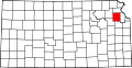
- Delaware Township, Jefferson County, Kansas
-
Delaware Township — Township — Location in Jefferson County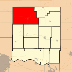
Coordinates: 39°21′45″N 95°28′46″W / 39.3625°N 95.47944°WCoordinates: 39°21′45″N 95°28′46″W / 39.3625°N 95.47944°W Country United States State Kansas County Jefferson Area – Total 88.54 sq mi (229.31 km2) – Land 88.44 sq mi (229.06 km2) – Water 0.1 sq mi (0.25 km2) 0.11% Elevation 945 ft (288 m) Population (2000) – Total 2,034 – Density 23/sq mi (8.9/km2) GNIS feature ID 0478222 Delaware Township is a township in Jefferson County, Kansas, USA. As of the 2000 census, its population was 2,034.
Contents
Geography
Delaware Township covers an area of 88.54 square miles (229.31 square kilometers); of this, 0.1 square miles (0.25 square kilometers) or 0.11 percent is water. The streams of Brush Creek, Cedar Creek, Coal Creek, Johannes Branch, North Cedar Creek, North Walnut Creek, Peter Creek, Rock Creek, South Cedar Creek and Walnut Creek run through this township.
Cities and towns
Unincorporated towns
- Half Mound
(This list is based on USGS data and may include former settlements.)
Adjacent townships
- Kapioma Township, Atchison County (north)
- Benton Township, Atchison County (northeast)
- Jefferson Township (east)
- Norton Township (east)
- Ozawkie Township (southeast)
- Douglas Township, Jackson County (southwest)
- Rock Creek Township (southwest)
- Cedar Township, Jackson County (west)
- Garfield Township, Jackson County (northwest)
Cemeteries
The township contains four cemeteries: Farrar, Graggs Chapel, Rose Hill and Saint Marys.
Major highways
References
External links
Municipalities and communities of Jefferson County, Kansas Cities McLouth | Meriden | Nortonville | Oskaloosa | Ozawkie | Perry | Valley Falls | Winchester
Townships Unincorporated
communitiesDunavant | Grantville | Half Mound | Lakeside Village | Mooney Creek | Newman | Rock Creek | Thompsonville | Williamstown
Categories:- Townships in Jefferson County, Kansas
- Kansas geography stubs


Wikimedia Foundation. 2010.