- Western North Carolina
-
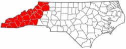 The counties most commonly associated with Western North Carolina.
Western North Carolina (often abbreviated as WNC) is the region of North Carolina which includes the Appalachian Mountains, thus it is often known geographically as the state's Mountain Region. It is sometimes included with upstate South Carolina as the "Western Carolinas", which is also counted as a single media market. The region covers an area of about 11,000 square miles (28,000 km2), and is roughly the size of the state of Massachusetts. The population of the region, as measured by the 2000 U.S. Census, is 1,015,268.
The term Land of the Sky (or Land-of-Sky) is a common nickname for this mountainous region and has been more recently adopted to refer to the Asheville area. (Areas in the northwest portion of the region, including Boone and Blowing Rock, commonly use the nickname "The High Country", rather than "Land of the Sky") The term is derived from the title of the book, Land of the Sky, written by Mrs. Frances Tiernan, under the pseudonym Christian Reid. The book often mentions the Great Smoky Mountains and Blue Ridge Mountains, the two main ranges that are found in Western North Carolina. The Asheville area regional government body, the Land-of-Sky Regional Council, utilizes the nickname.
Located east of the Tennessee state line and west of the Piedmont, Western North Carolina contains very few major urban centers. Asheville, North Carolina, located in the region's center, is the area's largest city and most prominent commercial hub. The Foothills region of the state is loosely defined as the area along Western North Carolina's eastern boundary; this region consists of a transitional terrain of hills between the Appalachians and the Piedmont Plateau of central North Carolina. The Eastern Band of Cherokee Indians have a reservation situated in the Western North Carolina region, adjacent to the Great Smoky Mountains National Park.
Contents
Subregions
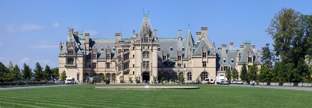
 The Biltmore Estate outside Asheville.
High Country
The northern counties in Western North Carolina are commonly known as the state's High Country.[1] Centered around Boone, the High Country boasts the area's most popular ski resorts, including Ski Beech, Appalachian Ski Mountain, and Sugar Mountain. The area also features many attractions, historical sites, and geological formations such as Linville Caverns, Grandfather Mountain, Blowing Rock, Tweetsie Railroad, Glendale Springs Inn, Shatley Springs, and Mystery Hill. Education, skiing tourism, and Christmas tree farming are among this area's most prominent industries, although agriculture and raising livestock also remain important.[2]
Tennessee Valley
Main article: Tennessee ValleyThe westernmost part of Western North Carolina is part of the Tennessee Valley. Asheville is the major hub of far western North Carolina. In this area, there are a few hydroelectric projects managed by the Tennessee Valley Authority, including Fontana Dam. Tourism, especially outdoor ventures such as canoeing, whitewater rafting, camping, and fishing are extremely important to local economies in the area.
Foothills
The Foothills is a region of transitional terrain between the Piedmont Plateau and the Appalachian Mountains, extending from the lower edge of the Blue Ridge escarpment into the upper Catawba, Yadkin, and Broad River valleys. The eastern slopes of the Blue Ridge drop sharply to the foothills section, going from 3500–4000 feet (1,000–1,200 m) at the top to only 1000-1500 feet at the base. The foothills region contains numerous lower peaks and isolated mountain ranges such as the South Mountains, Brushy Mountains, and Stone Mountain State Park. The foothills are divided into many small river and creek valleys that contain much of the region's population. Although no large cities are located in the foothills, the region does contain many small towns; the towns often developed around a single industry such as furniture or textiles. As these industries steadily moved to low-wage markets in Asia and Latin America over the last quarter-century, the foothills towns that depended upon them have often suffered from job and population loss; some of these towns are developing a new economy based on tourism and catering to affluent retirees who have settled in the region. Many farmers in the northern foothills are poultry farmers as well, and winemaking and vineyards are growing in popularity. Among the towns of the foothills region in North Carolina are Tryon, Columbus, Chimney Rock, Lake Lure, Forest City, Rutherfordton, Spindale, Mount Airy, Elkin, and Marion and the cities of North Wilkesboro, Wilkesboro, Hickory, Lenoir, Wilkesboro, and Morganton.
Higher education
Western Carolina University has three campuses in western North Carolina. Appalachian State University in Boone and UNC Asheville are the region's other two public universities. Several liberal-arts colleges are also located in the region. Mars Hill College, affiliated with the North Carolina Baptist Convention, is located 15 miles (24 km) north of Asheville. Founded in 1856, it is the oldest college or university in western North Carolina. Montreat College, affiliated with the Presbyterian Church, is located 15 miles (24 km) east of Asheville. Lees-McRae College, located near Banner Elk, North Carolina, is also affiliated with the Presbyterian Church. Warren Wilson College, located in Swannanoa, is noted for its strong pro-environment policies and social liberalism. Brevard College, located in Brevard, North Carolina, is affiliated with the United Methodist Church. Lenoir-Rhyne University, located in Hickory, is a private liberal arts university affiliated with the Evangelical Lutheran Church in America.
Transportation
Three major Interstate highways cross the region: Interstate 40, which traverses east-west, Interstate 77, which runs north-south through the northeastern section of Western North Carolina, and Interstate 26, which traverses north-south. Interstate 240 is the only auxiliary interstate route in the region and it serves downtown Asheville. Highway US 421, a multilane expressway, is the major highway in the northwestern part of the state, and US 74, US 64, US 19, US 23, and US 441 are the major highways in the far western part of the region. Highway US 321 runs north from Hickory to Watauga and Avery Counties before going into Tennessee. A National Scenic Byway, the Blue Ridge Parkway, runs through western North Carolina, ending near the Great Smoky Mountains National Park. Two major class 1 railroads run through the region, CSX and Norfolk Southern. In addition, two tourist railroads also operate in the area, the Tweetsie Railroad theme park and the Great Smoky Mountains Railroad.
Asheville Regional Airport (AVL), located southeast of the city of Asheville in Fletcher, also serves the area with non-stop jet service to Charlotte, North Carolina; Newark, New Jersey; Houston, Texas; Atlanta, Georgia; Orlando, Florida; Detroit, Michigan; O'Hare International Airport in Chicago, Illinois; Tampa, Florida; and LaGuardia Airport in New York City.
Economy
Tourism is a major part of the economy in the area which contains half of the Great Smoky Mountains National Park as well as the Nantahala and Pisgah National Forests. There are also several lakes and dams scattered throughout Western North Carolina like Lake Lure and Fontana Dam. Many visitors travel to the region every summer and autumn from major cities like Charlotte, Atlanta and Knoxville, to escape the hot weather and see the leaves change colors. The timber industry is also a major economic sector.
Appalachian Regional Commission
 Map showing 2001-2003 ARC economic designations for counties in "Appalachian" North Carolina, including all counties in Western North Carolina.See also: List of Appalachian Regional Commission counties#North_Carolina
The Appalachian Regional Commission was formed in 1965 to aid economic development in the Appalachian region, which was lagging far behind the rest of the nation on most economic indicators. The Appalachian region currently defined by the Commission includes 420 counties in 13 states, including 29 counties in North Carolina. The Commission gives each county one of five possible economic designations— distressed, at-risk, transitional, competitive, or attainment— with "distressed" counties being the most economically endangered and "attainment" counties being the most economically prosperous. These designations are based primarily on three indicators— three-year average unemployment rate, market income per capita, and poverty rate.[3]
In 2003, Appalachian North Carolina— which included all 24 counties of Western North Carolina and five counties in central North Carolina— had a three-year average unemployment rate of 6%, compared with 6.2% statewide and 5.5% nationwide. In 2002, Appalachian North Carolina had a per capita market income of $21,168, compared with $23,443 statewide and $26,420 nationwide. In 2000, Appalachian North Carolina had a poverty rate of 11.7%, compared to 12.3% statewide and 12.4% nationwide. Only one North Carolina county— Graham— was designated "Distressed," while six— Cherokee, McDowell, Mitchell, Rutherford, Swain, and Yancey— were designated "at-risk." Forsyth County (which is normally grouped with central North Carolina) was the only county given the "attainment" designation, and four others— Buncombe, Davie, Henderson, and Polk— were designated "competitive." Most Western North Carolina counties were designated "transitional," meaning they lagged behind the national average on one of the three key indicators. Graham County had Appalachian North Carolina's highest poverty rating, with 19.5% of its residents living below the poverty line. Forsyth had Appalachian North Carolina's highest per capita income at $26,987. Watauga County's unemployment rate of 2.3% was lowest of all 420 counties in the Appalachian region.[3]
Topography
There are 82 mountain peaks between 5,000 to 6,000 feet (1,500-1,800 m) in elevation in western North Carolina, and 43 peaks rise to over 6,000 feet (1,800 m). Mount Mitchell, 6,684 feet (2,037 m), is the highest point in eastern North America.[4] Valley locations are typically closer to 2,000 feet (610 m) AMSL.
The French Broad River is the largest river in the region; others include the Little Tennessee River and Swannanoa River. The Eastern Continental Divide runs through the region, dividing Tennessee-bound streams from those flowing through the Carolinas.
Area
Counties
Western North Carolina generally consists of 26 counties, that when combined form a total regional area of roughly 9,700 square miles (25,000 km2) the region is roughly the size of Vermont or New Hampshire. The counties commonly included in the region are as follows:
Cities and towns
Western North Carolina communities in the region include:
Over 10,000 population
Fewer than 10,000 population

Important unincorporated communities
- Cherokee (headquarters for the Eastern Band of the Cherokee)
- Cullowhee (site of Western Carolina University's main campus)
- Deals Gap (site of a nationally famous motorcycle and sportscar resort)
- Lake Junaluska (heaquarters for the World Methodist Council and site of a United Methodist camp and conference center)
See also
External links
References
Categories:- Appalachian culture
- Regions of North Carolina


Wikimedia Foundation. 2010.