- DuPont State Forest
-
DuPont State Forest
is a 10,000 acre (40 km²) tract, located in Henderson and Transylvania counties of North Carolina. The name originates from the fact that the DuPont company arranged the sale of the original tract to the state. Portions of the forest formerly contained a manufacturing facility for the production of X-ray film. Adjacent tracts have since been purchased and added to the state forest.
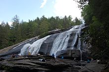
Nearly 100 miles (160 km) of multi-use trails and roads thread through the forest. The forest is widely used for many recreational activities, including mountain biking, hiking, horseback riding, swimming (where permitted), wading, and kayaking. Destinations include mountaintop views (such as Cedar Rock Mountain), pristine lakes (such as Lake Imaging, Lake Julia, Lake Dense, and Fawn Lake), and several magnificent waterfalls, including:
- Bridal Veil Falls
- Grassy Creek Falls
- High Falls
- Hooker Falls
- Triple Falls
- Wintergreen Falls
External links
Coordinates: 35°11′49″N 82°35′40″W / 35.1970234°N 82.5943072°W
Categories:- North Carolina geography stubs
- North Carolina state forests
- Protected areas of Henderson County, North Carolina
- Protected areas of Transylvania County, North Carolina
- DuPont State Forest
Wikimedia Foundation. 2010.

