- Crowders Mountain State Park
-
Crowders Mountain State Park North Carolina State Park Natural Monument (IUCN III) 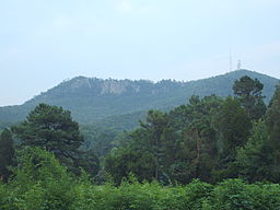
Named for: Crowder's Mountain Country United States State North Carolina County Gaston Location - coordinates 35°13′58″N 81°16′37″W / 35.23278°N 81.27694°WCoordinates: 35°13′58″N 81°16′37″W / 35.23278°N 81.27694°W - elevation 1,385 ft (422.1 m) Area 2,083 acres (843 ha) Founded 1974 Managed by North Carolina Department of Environment and Natural Resources 
 Location of Crowders Mountain State Park in North Carolina
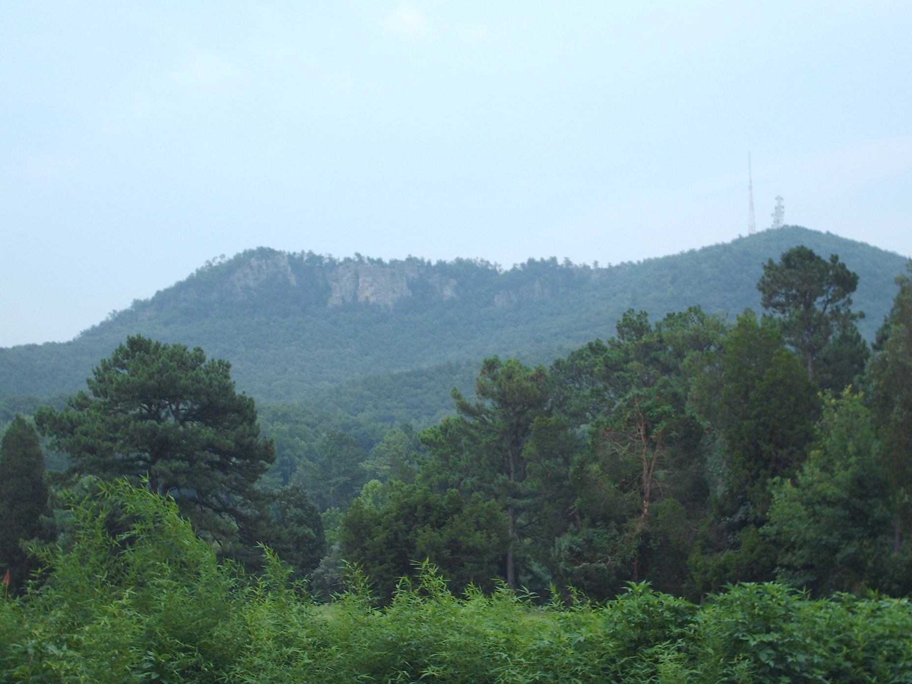
Website : Crowders Mountain State Park Crowders Mountain State Park is a 5126 acre (20.74 km²) North Carolina state park in Gaston County, North Carolina in the United States. It is near Kings Mountain, North Carolina and on the outskirts of Gastonia, North Carolina, it includes the peaks of Crowder's Mountain and King's Pinnacle. Crowders Mountain was named for Crowders Creek which originated near its base. Contrary to some historical information, Crowders Mountain was not named for Ulrich Crowder. (There is no historical evidence that he was ever in this area.) The cliffs are a popular destination for rock climbers.
Contents
Features
The mountain itself is a monadnock, an isolated erosional remnant that rises abruptly from the surrounding plain. Geologically neither Crowders Mountain nor King's Pinnacle are true mountains. Crowders Mountain sharply rises some 800 feet (240 m) above the surrounding countryside, and presents sheer rock cliffs that are 100 - 150 feet (46 m) in height. The mountain rises to 1,625 feet (495 m) above sea level. The peak is believed to be the remnant of a much higher mountain which formed some 400 - 500 million years ago and was gradually worn down by the elements. The park sets at the northeast end of the Kings Mountain Range, a 16-mile (26 km) long range of low peaks which include the site of the Battle of Kings Mountain of the American Revolution.
The Park contains two peaks:
- Crowders Mountain, 1,625 feet (495 m), is in the northeastern section of the park. 35°13′56″N 81°16′35″W / 35.232350°N 81.276439°W
- King's Pinnacle, 1,705 feet (520 m), is in the western section of the park. 35°12′28″N 81°18′45″W / 35.207817°N 81.312626°W
History
In the early 1970s a mining company conducted exploratory sampling on the mountain as preparation to purchase the mineral rights. Thanks to grassroots efforts by local citizens, educational institutions, and organizations the state government was convinced that the area should be set aside and protected due to significant natural communities, plants and animals, intrinsic beauty, and unique recreational opportunities. In 1973 the State of North Carolina officially designated the area as Crowders Mountain State Park and it opened to the public in 1974. King's Pinnacle was added to the park in 1987. Another 2,000 acres (8.1 km2) was added in the year 2000 and officially connected the park with Kings Mountain State Park and Kings Mountain National Military Park, both in South Carolina.
Trails
Several hiking trails lead to the summit of Crowders Mountain, and from the summit it is possible on a clear day to see the skyscrapers of Charlotte, North Carolina to the east.
- Crowders Trail - Strenuous, 2.5 miles (4.0 km). This trail winds along the base of Crowders Mountain which ultimately leads to the top of the mountain.
- Backside Trail - Strenuous, .7 miles. From the Crowders Trail this trail leads around the backside of the mountain to the top.
- Rocktop Trail - Strenuous, .9 miles. Admittedly the most difficult and technical trail in the park. It travels along the ridge of Crowders Mountain so each side has steep drop offs and unseen cliffs.
References
State Parks of North Carolina, Walter C. Biggs and James F. Parnell, Authors. John F. Blair, Publisher. 1989 ISBN 0895870711
External links
Categories:- Protected areas established in 1974
- North Carolina state parks
- Protected areas of Gaston County, North Carolina
- North Carolina geography stubs

Wikimedia Foundation. 2010.