- Linville Falls
Infobox Waterfall
image_width=180px
name=Linville Falls
location=Blue Ridge Mountains ,Burke County ,North Carolina
type=Tiered
height=Convert|150|ft|m|0|abbr=on
drop=
number_drops=4
flow=
heightrank=
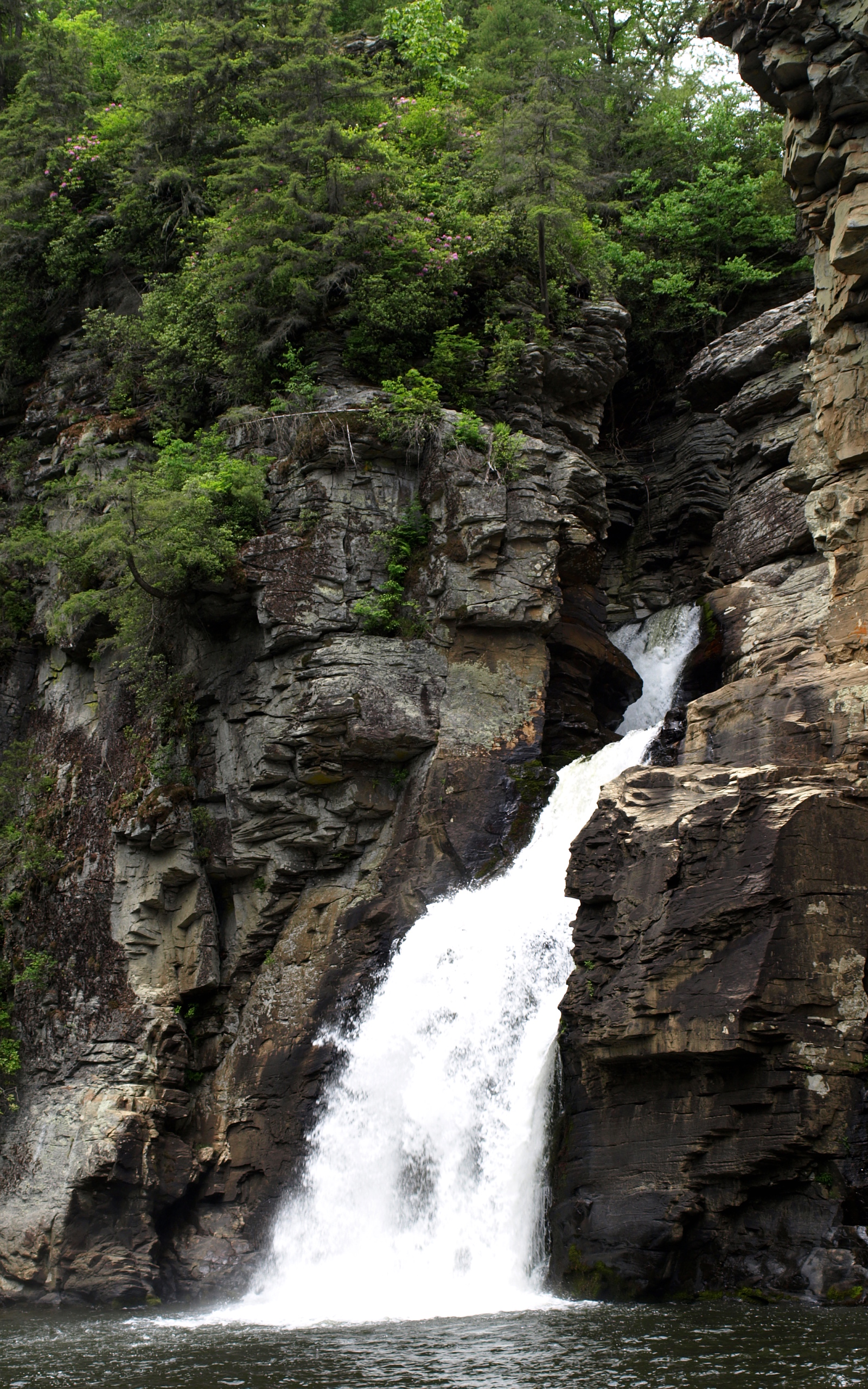
coordinates=coord|35.9495715|-81.9267782Linville Falls is a
waterfall located in theBlue Ridge Mountains ofNorth Carolina in theUnited States . [gnis|1012892] The falls move in several distinct steps, beginning in a twin set of upper falls, moving down a small gorge, and finally culminating in a high-volume 45-foot drop. It is named for theLinville River , which goes over the falls. Linville Falls has the highest volume of any waterfall on the Northern Edge of the Blue Ridge Mountains [http://www.itpi.dpi.state.nc.us/caroclips/wfalls/linvillefalls.html North Carolina DPI Waterfall Website] ] .Natural History
Linville Falls marks the beginning of the
Linville Gorge , which is formed by theLinville River , which continues on after the falls before finally ending nearLake James .History
According to personnel at Linville Falls, the falls was used by local Native Americans to execute prisoners. No one is known to have survived a fall over the final plunge.
At one time, the upper section of the main plunge was the same height as the lower section, however,
flooding caused the upper section to collapse on top of the lower falls, making the lower falls a considerably longer plunge.Visiting the Falls
The falls is owned by the
National Park Service , which operates a visitor center and several miles of non-handicapped accessible trails with 4 overlooks for the falls. The 0.5 mile Upper Falls trail leads to the top of the falls, where visitors can see the small twin upper falls and the water spiraling through a small canyon on its way to the main falls. The Erwin's View trail leads to 2 overlooks, the Chimney View overlook (0.7 miles) and the Erwin's View overlook (0.8 miles). The 0.5 mile Plunge Basin Trail leads to the Plunge Basin Overlook, which provides a view of the falls from the other side of the river. Finally, the 0.7 mile Gorge Trail, which branches off from the Plunge Basin trail, leads to an area near the foot of the falls.Swimming is prohibited at all areas of Linville Falls, as many deaths have occurredFact|date=August 2008.Nearby Falls
[http://www.ncwaterfalls.com/duggers1.htm Duggers Creek Falls] is located in the Linville Falls National Recreation Area. It can be reached by the short Duggers Creek Falls trail, which starts at the back right corner of the paved parking lot from the Visitor Center. The small falls can be seen on the right from a footbridge over the creek.
References
External links
At NCWaterfalls.com
* [http://www.ncwaterfalls.com/lin1.htm Linville Falls at NCWaterfalls.com]
* [http://www.ncwaterfalls.com/duggers1.htm Duggars Creek Falls at NCWaterfalls.com]At Other Sites
* [http://www.cs.unca.edu/nfsnc/recreation/wncwaterfalls/linvillefalls.htm UNC Asheville's Linville Falls Site]
* [http://www.brptrails.com/brp3164.htm BRP Trails: Linville Falls Trails]
* [http://www.itpi.dpi.state.nc.us/caroclips/wfalls/linvillefalls.html NC DPI's Linville Falls Page]
* [http://www.ashevillenow.com/s_outdoorActivities/waterfalls/burke_county_nc_waterfalls.asp Linville Falls on AshevilleNow's WNC Waterfalls Guide]
* [http://www.panoramio.com/map/#lt=35.9495715&ln=-81.9267782&z=4&k=2&a=1 Photos from Panaramio]
Wikimedia Foundation. 2010.