Mills River, North Carolina
- Mills River, North Carolina
-
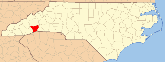
Mills River is a town located in Henderson County, North Carolina (USA). It is part of the Asheville Metropolitan Statistical Area.
It lies in the northwestern part of the county, covering roughly 22 square miles (57 km2), and located near Etowah and Fletcher. It is home to approximately 7,000 people, and it was incorporated into a city in 2003, mostly thanks to the efforts of fireman Roger Snyder, who is now the current mayor.
Mills River is the second largest town in Henderson County, and it is home to one river, the Mills River (South fork and North fork), and four schools, Mills River Elementary, Glenn C. Marlow Elementary, Rugby Middle School, and West Henderson High School.
Mills River is among the oldest communities in Henderson County with its first landholder receiving a deed from the State of North Carolina in 1787. It was once a thriving agricultural community, often called the “fertile crescent”.
External links
Coordinates: 35°23′18″N 82°34′00″W / 35.38833°N 82.5666667°W / 35.38833; -82.5666667
Categories:
- North Carolina geography stubs
- Towns in North Carolina
- Populated places in Henderson County, North Carolina
- Asheville metropolitan area
- Populated places established in 2003
Wikimedia Foundation.
2010.
Look at other dictionaries:
Mills River (North Carolina) — This article is about a river in western North Carolina. For the nearby town of the same name, see Mills River, North Carolina. The Mills River is located in Transylvania and Henderson counties, North Carolina, USA is a tributary of the French… … Wikipedia
Haw River, North Carolina — Infobox Settlement official name = Haw River, North Carolina settlement type = Town nickname = motto = imagesize = image caption = image mapsize = 250x200px map caption = Location of Haw River, North Carolina mapsize1 = map caption1 = subdivision … Wikipedia
Mills River (Carolina del Norte) — Mills River Pueblo de los Estados Unidos … Wikipedia Español
Mills River Chapel — U.S. National Register of Historic Places … Wikipedia
Elk River (North Carolina) — The Elk River rises in Avery County, North Carolina just south of the small community of Elk Park, North Carolina on U.S. Highway 19E. in Pisgah National Forest. For most of the river s course, it runs in a deep gorge. Just before the Elk River… … Wikipedia
Deep River (North Carolina) — Map of the Cape Fear drainage basin showing Deep River The Deep River is a tributary of the Cape Fear River, approximately 125 miles (200 km) long, in north central North Carolina in the United States. Course It rises in the piedmont country in… … Wikipedia
Flat River (North Carolina) — The Flat River is a river in Southern Person County, North Carolina and a portion of Durham County, North Carolina.The River flows from S. Person County to combine with the Little and Eno Rivers to flow into the Neuse River. The river is the… … Wikipedia
North Carolina locations by per capita income — North Carolina is the twenty eighth richest state in the United States of America, with a per capita income of $20,307 (2000). North Carolina Places Ranked by Per Capita Income Rex, North Carolina $148,073 Biltmore Forest, North Carolina $85,044… … Wikipedia
North Carolina — North Carolinian. a state in the SE United States, on the Atlantic coast. 5,874,429; 52,586 sq. mi. (136,198 sq. km). Cap.: Raleigh. Abbr.: NC (for use with zip code), N.C. * * * State (pop., 2000: 8,049,313), southern Atlantic region, U.S. Lying … Universalium
Rocky Mount, North Carolina — Infobox Settlement official name = City of Rocky Mount settlement type = City nickname = City on the Rise Rock City motto = postal code type = ZIP Code postal code = 27801 image caption = image mapsize = 250px map caption = Location of Rocky… … Wikipedia