- Midland, North Carolina
-
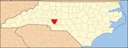
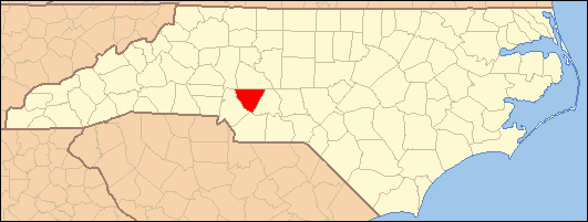
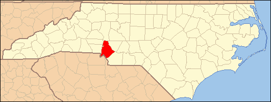
Town of Midland Location of Midland in North Carolina

Coordinates: 35°13′38″N 80°30′03″W / 35.22722°N 80.50083°WCoordinates: 35°13′38″N 80°30′03″W / 35.22722°N 80.50083°W Country  United States
State  North Carolina
Counties Cabarrus, Mecklenburg[1] Founded 1913 Incorporated 2000 Population (2006) – Total 2,978 Time zone EST (UTC-5) – Summer (DST) EDT (UTC-4) ZIP Code 28107 Website www.townofmidland.us Midland is a town in southern Cabarrus County in the U.S. state of North Carolina.[1] Located in the south-central portion of the state, it lies in the region known as the Piedmont. The name of the town is derived from its location approximately one-half way between Charlotte and Oakboro on the railroad line. As the town was not yet incorporated at the time of the 2000 census, it was not listed then, but 2006 Census Bureau estimates give the town's population as 2,978.[1]
Visitors and new residents to the area are often surprised to learn the local pronunciation of the town's name. In local parlance, "Midland" is pronounced as a spondee, with nearly equal verbal emphasis on both first and last syllables. Other Midlands around the country, including those in Texas and Michigan, are generally pronounced with emphasis on the first syllable. While Midlanders may refer to "MID-lind," Texas, they themselves live in "MID-LAND," North Carolina.
US Hwy 601 and NC 24/27 are the major highways. At this writing (January 2007) there is one traffic signal in the town at the intersection of Hwy. 601 and State Road 24/27, which is north of Midland proper and was once known locally as "Hell's Half Acre." The U.S. Postal Service has maintained a post office in Midland for many years (Zip code 28107), and rural mail routes extend from Midland into portions of four counties.
Contents
History
Midland began as a railroad town about 1913 with the arrival of rail service. The town is now incorporated, as of 2000. Prior to Midland's becoming a railroad village, a community named Garmon existed in the area and appears on an 1864 map of North Carolina.
Formerly, the economy of Midland was essentially agricultural with some textile-related manufacturing jobs. With the growth of Charlotte, N.C. to the west, farming has played a decreasing role in the economic life of the town. Increasingly, Midland has become a bedroom community for those commuting to work in nearby Charlotte and Concord. For many years, there were very few "outsiders" moving to Midland, but over the past two decades, many people with no familial roots in the area have settled there. New residents are attracted to the area for its lower taxes, less expensive housing and real estate prices, and a more rural flavor than that which is to be found in Charlotte or the surrounding larger communities.
The Reed Gold Mine, site of the first discovery of gold in the United States, is located east of the town. The Reed Gold Mine is now an historic site under State management and is open to the public. Visitors to the mine can tour a museum with extensive information and displays on North Carolina gold mining, and can walk through several hundred feet of mine tunnels. The area was an important gold mining center in the 19th century; however, gold mining activity in the region predates the founding of Midland.
Geography
The climate in Midland is temperate, with chilly winters and hot summers. Thunderstorms are frequent in warmer weather. Severe weather occurs occasionally, and a few tornadoes have been recorded in Midland and its vicinity. Snow accumulations occur on occasion in the winter, and anywhere from zero to three significant accumulations of snow might reasonably be expected in an average winter. Accumulating snows generally melt away between snow events, and there is no consistent snowpack in winter. Pleasantly warm daytime temperatures may be experienced into November. Rainfall averages 40–45 inches (1,000–1,100 mm) per year.
The town sits approximately 500–550 feet (150–170 m) above sea level. The land is gently rolling with no especially high points. The most common soil type is a red clay. The area is drained by the Rocky River, which is relatively small and generally shallow. Trees are abundant. There are no significant lakes in the town. Coordinates for Midland are 35°13′38″N 80°30′03″W / 35.22722°N 80.50083°W. The town is located approximately 249 miles (401 km) northeast of Atlanta, 526 miles (847 km) southwest of New York City, 614 miles (988 km) southeast of Chicago, and 650 miles (1,050 km) north of Miami. From Midland, it is 2,423 miles (3,899 km) to the Equator and 3,792 miles (6,103 km) to the North Pole.
During the past two decades, new businesses have tended to locate north of Midland near the intersection of Hwy 601 and State Road 24/27. Midland has an increasing number of businesses owing mainly to companies locating in the town which, with improved highways, is now more convenient to Charlotte and surrounding areas. Essential services remain limited. A physician's office is now located in Midland, but hospitals with emergency services are located in Concord and Charlotte. A few family-type restaurants and food stands may be found in Midland. A bank is located in the town. Automobile fuel and repairs are available. A public elementary school is located near the town, and a middle school and a high school serving the area are located near Concord. There are no military installations in the area.
Nearby communities include the settlement of Cabarrus, also known as Cabarrus Station, a former railroad stop like Midland. Also nearby are the communities of Locust and Stanfield, located in adjoining Stanly County, N.C., and only a few minutes' drive from Midland by automobile. These communities are similar to Midland in many ways, but Locust does now have a chain supermarket and some other nationally-branded businesses.
Transportation to Midland is limited to automobile traffic. The town is no longer served by passenger rail service, and there is no public general aviation airport within 15–20 miles (24–32 km). Commercial flights to the area are usually handled through the airport at Charlotte, approximately one hour's drive to the west. Charlotte's airport has several hundred passenger flights per day with nonstop service to many locations in North America as well as service to Europe and the Caribbean basin. Some air passengers also use the airport at Greensboro, N.C., or at Raleigh/Durham, although these latter airports are two hours or more travel time by automobile. The closest seaports are located along the Atlantic Ocean approximately 165 miles (266 km) east of the town.
Nearby recreation includes access to lakes, museums, professional sports, and extensive shopping in surrounding areas. The beaches of both Carolinas are popular vacation destinations. The Appalachian Mountains of North Carolina rise to the west and are also a popular vacation or day-trip destination. The cool, verdant heights of the Appalachian Mountains provide relief from the summer heat of the Piedmont and also winter recreation such as snow skiing. Mt. Mitchell, the highest mountain in the eastern U.S. at a height of 6,684 feet (2,037 m), is 106 miles (171 km) west-northwest of Midland.
References
- ^ a b c "Subcounty population estimates: North Carolina 2000-2006" (CSV). United States Census Bureau, Population Division. 2007-06-28. http://www.census.gov/popest/cities/files/SUB-EST2006_37.csv. Retrieved 2008-05-28.
External links
- Town website
- Bethel Glen | A Cabarrus County Neighborhood - Midland, NC
- - Joyce and Jim Lavene - Midland authors
Municipalities and communities of Cabarrus County, North Carolina Cities Concord | Locust‡ | Kannapolis‡
Towns Harrisburg | Midland‡ | Mount Pleasant
Unincorporated
communityOdell School | Rimertown
Footnotes ‡This populated place also has portions in an adjacent county or counties
Municipalities and communities of Mecklenburg County, North Carolina City 
Towns Cornelius | Davidson‡ | Huntersville | Matthews | Midland‡ | Mint Hill‡ | Pineville | Stallings‡ | Weddington‡
Unincorporated
communitiesCaldwell | Hopewell
Footnotes ‡This populated place also has portions in an adjacent county or counties
Categories:- Populated places established in 1913
- Populated places in Cabarrus County, North Carolina
- Towns in North Carolina
- Populated places in Mecklenburg County, North Carolina

Wikimedia Foundation. 2010.