- Monroe County, Missouri
-
Monroe County, Missouri 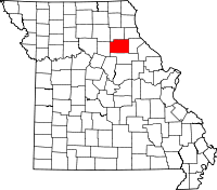
Location in the state of Missouri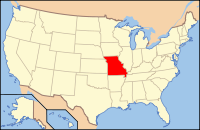
Missouri's location in the U.S.Founded 1831 Named for President James Monroe Seat Paris Largest city Monroe City Area
- Total
- Land
- Water
670.23 sq mi (1,736 km²)
645.98 sq mi (1,673 km²)
24.24 sq mi (63 km²), 3.62%Population
- (2010)
- Density
8,840
14/sq mi (6/km²)Time zone Central: UTC-6/-5 Monroe County is a county located in the U.S. state of Missouri. The county was organized in 1831 and named for U.S. President James Monroe. As of 2010, the population was 8,840. Its county seat is Paris[1].
Contents
History
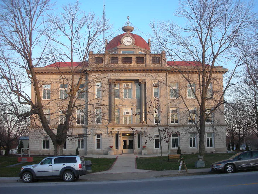
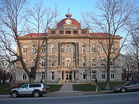 The Monroe County Courthouse in Paris.
Monroe County was one of several along the Missouri River settled by migrants from the Upper South, especially Kentucky and Tennessee. They brought slaves and slaveholding traditions with them, and quickly started cultivating crops similar to those in Middle Tennessee and Kentucky: hemp and tobacco. They also brought characteristic antebellum architecture and culture. The county was considered at the heart of what was called Little Dixie.[2]
Monroe County was one of only two jurisdictions in Missouri to be carried by Democrat George McGovern in the 1972 presidential election against incumbent Republican president Richard Nixon. The other was the City of St. Louis.
The American writer Mark Twain was born in Monroe County. The Mark Twain Birthplace Historic Site Mark Twain Birthplace State Historic Site in Mark Twain State Park marks this.
Geography
According to the 2000 census, the county has a total area of 670.23 square miles (1,735.9 km2), of which 645.98 square miles (1,673.1 km2) (or 96.38%) is land and 24.24 square miles (62.8 km2) (or 3.62%) is water.[3]
Adjacent counties
- Shelby County (north)
- Marion County (northeast)
- Ralls County (east)
- Audrain County (south)
- Randolph County (west)
Major highways
Demographics
Historical populations Census Pop. %± 1900 19,716 — 1910 18,304 −7.2% 1920 16,414 −10.3% 1930 13,466 −18.0% 1940 13,195 −2.0% 1950 11,314 −14.3% 1960 10,688 −5.5% 1970 9,542 −10.7% 1980 9,716 1.8% 1990 9,104 −6.3% 2000 9,311 2.3% 2010 8,840 −5.1% As of the census[4] of 2010, there were 8,840 people, 3,656 households, and 2,566 families residing in the county. The population density was 14 people per square mile (6/km²). There were 4,565 housing units at an average density of 7 per square mile (3/km²). The racial makeup of the county was 94.66% White, 3.83% Black or African American, 0.41% Native American, 0.12% Asian, 0.03% Pacific Islander, 0.16% from other races, and 0.78% from two or more races. 0.56% of the population were Hispanic or Latino of any race. 24.7% were of German, 23.2% American, 14.2% English and 11.8% Irish ancestry according to Census 2000.
There were 3,656 households out of which 31.60% had children under the age of 18 living with them, 59.10% were married couples living together, 7.70% had a female householder with no husband present, and 29.80% were non-families. 26.50% of all households were made up of individuals and 12.90% had someone living alone who was 65 years of age or older. The average household size was 2.50 and the average family size was 3.02.
In the county the population was spread out with 25.90% under the age of 18, 7.30% from 18 to 24, 25.00% from 25 to 44, 24.20% from 45 to 64, and 17.60% who were 65 years of age or older. The median age was 39 years. For every 100 females there were 96.40 males. For every 100 females age 18 and over, there were 93.10 males.
The median income for a household in the county was $30,871, and the median income for a family was $36,895. Males had a median income of $26,534 versus $20,440 for females. The per capita income for the county was $14,695. About 8.30% of families and 11.90% of the population were below the poverty line, including 14.00% of those under age 18 and 10.30% of those age 65 or over.
Cities and towns
See also
- National Register of Historic Places listings in Monroe County, Missouri
References
- ^ "Find a County". National Association of Counties. http://www.naco.org/Counties/Pages/FindACounty.aspx. Retrieved 2011-06-07.
- ^ The Story of Little Dixie, Missouri, Missouri Division, Sons of Confederate Veterans, accessed 3 June 2008
- ^ "Census 2000 U.S. Gazetteer Files: Counties". United States Census. http://www.census.gov/tiger/tms/gazetteer/county2k.txt. Retrieved 2011-02-13.
- ^ "American FactFinder". United States Census Bureau. http://factfinder.census.gov. Retrieved 2008-01-31.
External links
- Digitized 1930 Plat Book of Monroe County from University of Missouri Division of Special Collections, Archives, and Rare Books

Shelby County Marion County Randolph County 
Ralls County  Monroe County, Missouri

Audrain County Municipalities and communities of Monroe County, Missouri Cities Madison | Monroe City‡ | Paris

Villages Florida | Goss | Holliday | Stoutsville
Unincorporated
communityFootnotes ‡This populated place also has portions in an adjacent county or counties
Categories:- Missouri counties
- 1831 establishments in the United States
- Populated places established in 1831
- Little Dixie (Missouri)
- Monroe County, Missouri


Wikimedia Foundation. 2010.