- Chesterfield, Missouri
-
Chesterfield, Missouri — City — Location of Chesterfield, Missouri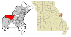
Coordinates: 38°39′12″N 90°33′15″W / 38.65333°N 90.55417°WCoordinates: 38°39′12″N 90°33′15″W / 38.65333°N 90.55417°W Country United States State Missouri County St. Louis Area - Total 32.7 sq mi (84.8 km2) - Land 31.5 sq mi (81.6 km2) - Water 1.2 sq mi (3.2 km2) Elevation 479 ft (146 m) Population (2010) - Total 47,484 - Density 1,485.4/sq mi (573.5/km2) Time zone Central (CST) (UTC-6) - Summer (DST) CDT (UTC-5) FIPS code 29-13600[1] GNIS feature ID 0755881[2] Website chesterfield.mo.us Chesterfield is a second-ring western suburb of St. Louis and is the largest city in west St. Louis County, Missouri, United States. As of the 2010 census the population is 47,484. Chesterfield also celebrated its 20th birthday in 2008.
Contents
Geography
Chesterfield is located at 38°39′12″N 90°33′15″W / 38.65333°N 90.55417°W (38.653402, -90.554255)[3] about 25 miles (40 km) west of St. Louis, Missouri. According to the United States Census Bureau, the city has a total area of 32.7 square miles (85 km2), of which 31.5 square miles (82 km2) is land and 1.2 square miles (3.1 km2) (3.73%) is water.
Portions of Chesterfield are located in the floodplain of the Missouri River, now known as Chesterfield Valley, formerly Gumbo Flats. This area was submerged during the Great Flood of 1993; higher levees built since then have led to extensive commercial development in the valley. Chesterfield Valley is the location of Spirit of St. Louis Airport, used for corporate aviation, as well as the longest outdoor strip mall in America [1]. The remainder of Chesterfield is located on the bluffs above the floodplain, and includes residential and retail development.
Demographics
Historical populations Census Pop. %± 1990 37,991 — 2000 46,802 23.2% 2010 47,484 1.5% U.S. Decennial Census As of the census[1] of 2000, there were 46,802 people, 18,060 households, and 13,111 families residing in the city. The population density was 1,485.4 people per square mile (573.5/km²). There were 18,738 housing units at an average density of 594.7 per square mile (229.6/km²). The racial makeup of the city was 92.30% White, 0.86% African American, 0.12% Native American, 5.56% Asian, 0.02% Pacific Islander, 0.39% from other races, and 0.74% from two or more races. Hispanic or Latino of any race were 1.55% of the population.
There were 18,060 households out of which 33.2% had children under the age of 18 living with them, 65.5% were married couples living together, 5.4% had a female householder with no husband present, and 27.4% were non-families. 23.6% of all households were made up of individuals and 8.8% had someone living alone who was 65 years of age or older. The average household size was 2.53 and the average family size was 3.03.
In the city the population was spread out with 24.6% under the age of 18, 5.9% from 18 to 24, 25.0% from 25 to 44, 29.7% from 45 to 64, and 14.7% who were 65 years of age or older. The median age was 42 years. For every 100 females there were 91.6 males. For every 100 females age 18 and over, there were 88.2 males.
According to a 2007 estimate,[4] the median income for a household in the city was $92,977, and the median income for a family was $117,092. Males had a median income of $74,934 versus $39,217 for females. The per capita income for the city was $43,288. About 1.8% of families and 2.6% of the population were below the poverty line, including 2.8% of those under age 18 and 1.7% of those age 65 or over.
History
For many years, Chesterfield was an all inclusive place name for a vast unincorporated area of St. Louis County. Police and fire protection were fragmented and sporadic, the former provided by St. Louis County. As the population grew, malls and other developments sprang up. But many residents were concerned by the lack of quality services and that the municipal sales tax failed to beneifit the community.
An organization was formed calling itself the "Chesterfield Incorporation Study Committee." Headed by president John A. Nuetzel, himself former president of the River Bend Association, (a zoning watchdog) the members passed the hat at neighborhood meetings, engaged legal help, drew up metes and bounds and forced several unsuccessful votes for incorporation. After a number of years, in 1989, The City of Chesterfield was finally established by its residents and thrives today as a major residential, business, retail and transportation center on the western edge of St. Louis County.
- On January 24, 1967, a violent F4 tornado ripped a 21-mile (34 km) path of destruction across St. Louis County. It was the fourth-worst tornado to hit the St. Louis metro area and the most recent F4 tornado to hit the city. It set down near the Chesterfield Manor nursing home, and then moved through River Bend Estates and across northeast St. Louis County.[5]
Historical communities
The present-day city of Chesterfield is made up of several smaller historical communities, including:
- Bellefontaine (French for, "beautiful spring"), or as the locals called it, "Hilltown", dates to about 1837 with the arrival of August Hill. The first post office was established as Bellemonte ("beautiful mountain") in 1851. Eighteen years later, in 1869, the town and post office name were both changed to Bellefontaine. Rinkel's Market was a familiar landmark for years, at the intersection of present day Olive Blvd. and Chesterfield Parkway (where Charlie Gitto's from the hill is now).
- The town of Lake started out as "Hog Hollow," in about 1850. The post office was established as Hog Hollow, in 1871; but a year later the town's name was changed, to what some thought was the more suitable name of Lake. Zierenberg's General Merchandise and Saloon (built around 1880), was a well known landmark, at the 18- mile marker on Olive Street Road. The original structure was destroyed by fire in 1918. It was replaced by the still existing structure, on the same site (Olive Blvd. and Hog Hollow Road).
- Gumbo is located in the valley at the present intersection of Chesterfield Airport Road and Long Road. A notable landmark (until it was razed in 1998), was the old Twenty Five Mile House - so named because of its distance from downtown St.Louis. Gumbo's name derived from its soil, which though very rich and silty, when wet became gumbo mud. A substance very similar to gravel was made from Gumbo mud and used for streets and sidewalks in Forest Park during the 1904 World's Fair. Gumbo's post office operated from 1882 to 1907.
- Monarch (earlier called Atherton, then Eatherton), was one of the settlements that sprang up along the Chicago, Rock Island and Pacific rail line, when it came through the valley in the late 1870s. William Sutton's General Store stood on the northwest corner of Eatherton and Centaur Roads. Their post office operated from 1895 to 1907, when the mail was transferred to Chesterfield. A well known residence in Monarch was named "The Shadows"; it still survives, with a commanding view from its bluff site.
- Bonhomme had a colorful life. The name is French for "good man." This small community, at the extreme western end of Olive Street Road, was close to the Howell's Ferry landing. It had a blacksmith shop, grist mill, store, post office and Fenn's saw mill; but it was all washed away in the late 19th century by the Missouri River. Bonhomme was a popular name in St. Louis County; with Bonhomme streets, roads, creeks, churches and townships still so-named. However, this Bonhomme is the only one that ever had its own post office.
Transportation
Highways and major roads
Interstate 64 runs East-West through Chesterfield, there are seven exits serving the city (exit numbers 14-21). Missouri Route 340 (Olive Blvd.) runs on an East-West though much of Chesterfield before turning Southwest near the I-64 Interchange, Rt 340 is known as Clarkson Rd South of junction. Missouri Route 141 (Woodsmill Rd) runs along the Eastern border between Chesterfield and Town and Country, Missouri. Rt. 141's northern terminus is located in Chesterfield at Olive Blvd. The Missouri Department of Transportation (MoDOT) and St. Louis County Department of Highways and Traffic (DHT) will begin construction of Route 141 in Chesterfield in 2009.[6] MoDOT will expand Route 141 between just south of Ladue Road (Route AB) to Olive Road (Route 340). DHT will extend Route 141 from Olive Road to the Page Avenue Extension (Route 364) at the Maryland Heights Expressway[7]
Public transportation
Public transportion is provided by Metro and connects Chesterfield to many other portions of Greater St. Louis by numerous bus routes.
Air
Spirit of St. Louis Airport, is located in the Chesterfield Valley; the airport is owned by St. Louis County.[8]
Education
Primary and secondary schools
Chesterfield has a number of elementrary and middle schools and two high schools. The Rockwood School District serves the Western portions of the city, while the Parkway School District serves the Eastern portions of Chesterfield.
Public libraries
St. Louis County Library Samuel C. Sachs Branch is in Chesterfield.[9][10]
Economy
Reinsurance Group of America, Dierbergs, Kellwood and Broadstripe have their headquarters in Chesterfield.[11]
Top employers
According to the City's 2009 Comprehensive Annual Financial Report,[12] the top employers in the city are:
# Employer # of Employees 1 St. Luke's Hospital 3,645 2 Pfizer 1,077 3 Parkway School District 1,027 4 McBride & Son Homes 700 5 Reinsurance Group of America 600 6 Amdocs 550 7 Mercy Health Plans 370 7 Rockwood School District 363 9 IKON Office Solutions 293 10 RGA Technology Partners 289 Sports
- St. Louis Bandits (NAHL) play at the Hardee's Iceplex in the Chesterfield Valley.
Attractions
Faust Park contains an updated playground, historical village, walking trail, carousel, and the The Butterfly House, which opened in 1998. A nearby giant cement butterfly sculpture by Bob Cassilly was dedicated in 1999.
Notable residents
Chesterfield is home to many high profile business professionals, athletes, and musicians, including:
- Jeremy Maclin, former Missouri Tigers wide receiver, current wide receiver for the Philadelphia Eagles.
- Davis Payne, head coach of the St. Louis Blues
- Max Scherzer, MLB pitcher for the Detroit Tigers.
- Yan Stastny, Professional Hockey Player; St. Louis Blues, Parkway Central High School alumnus.
- Jim Talent, Former U.S. Senator (R).
- Adam Wainwright, MLB pitcher for the St. Louis Cardinals.
- Kurt Warner, NFL Quarterback for Arizona Cardinals, 1999, 2001 NFL MVP, 1999 Super Bowl MVP.
- Nelly, Musician
- Al Lowe, Games Designer and creator of Leisure Suit Larry.
References
- ^ a b "American FactFinder". United States Census Bureau. http://factfinder.census.gov. Retrieved 2008-01-31.
- ^ "US Board on Geographic Names". United States Geological Survey. 2007-10-25. http://geonames.usgs.gov. Retrieved 2008-01-31.
- ^ "US Gazetteer files: 2010, 2000, and 1990". United States Census Bureau. 2011-02-12. http://www.census.gov/geo/www/gazetteer/gazette.html. Retrieved 2011-04-23.
- ^ http://factfinder.census.gov/servlet/ACSSAFFFacts?_event=Search&geo_id=01000US&_geoContext=01000US%7C04000US34%7C05000US34003%7C06000US3400372360&_street=&_county=chesterfield&_cityTown=chesterfield&_state=04000US29&_zip=&_lang=en&_sse=on&ActiveGeoDiv=geoSelect&_useEV=&pctxt=fph&pgsl=010&_submenuId=factsheet_1&ds_name=ACS_2007_3YR_SAFF&_ci_nbr=null&qr_name=null®=null%3Anull&_keyword=&_industry=
- ^ http://www.crh.noaa.gov/lsx/?n=jan241967tornado
- ^ "Route 141 Improvement Project (Ladue to Olive)". MoDOT. http://www.modot.org/stlouis/major_projects/rte141improvementproject.htm. Retrieved 2008-06-10.
- ^ "Page to Olive Connector Study". St. Louis County Department of Highways and Traffic. http://www.stlouisco.com/hwyweb/Publications/Page_to_Olive_Connector/PagetoOliveConnector.html. Retrieved 2008-10-15.
- ^ FAA Airport Master Record for SUS (Form 5010 PDF), effective 2007-07-05
- ^ "Samuel C. Sachs Branch." St. Louis County Library. Retrieved on August 18, 2009.
- ^ "Chesterfield city, Missouri." U.S. Census Bureau. Retrieved on August 18, 2009.
- ^ "Contact Us." Broadstripe. Retrieved on March 5, 2010.
- ^ City of Downers Grove Comprehensive Annual Financial Report, for the Year ended June 30, 2009
External links
Greater St. Louis Illinois · Missouri · United States of America Topics 
Central city Largest cities
(over 20,000 in 2000)Affton CDP · Alton · Ballwin · Belleville · Chesterfield · Collinsville · East St. Louis · Edwardsville · Ferguson · Florissant · Granite City · Hazelwood · Kirkwood · Maryland Heights · Mehlville CDP · Oakville CDP · O'Fallon, Illinois · O'Fallon, Missouri · Saint Charles · St. Peters · Spanish Lake CDP · University City · Webster Groves · WildwoodLargest towns
and villages
(over 10,000 in 2000)Arnold · Bellefontaine Neighbors · Berkeley · Bridgeton · Cahokia · Clayton · Concord CDP · Crestwood · Creve Coeur · Fairview Heights · Farmington · Festus · Glen Carbon · Godfrey · Jennings · Lake St. Louis · Lemay CDP · Manchester · Overland · St. Ann · Swansea · Town and Country · Washington · Wentzville · Wood RiverMissouri Counties Franklin · Jefferson · Lincoln · St. Charles · Saint Francois · St. Louis City · St. Louis County · Warren · WashingtonIllinois Counties Subregions  State of Missouri
Jefferson City (capital) Topics Government · Delegations · Geography · Transportation · History · People · Visitor Attractions
Society Regions Bootheel · Crowley's Ridge · Dissected Till Plains · Four State Area · Henry Shaw Ozark Corridor · Honey Lands · Lead Belt · Lincoln Hills · Little Dixie · Loess Hills · Mid-Missouri · Mississippi Embayment · Missouri Rhineland · Northern Plains · Osage Plains · Ozark Plateau · Platte Purchase · Pony Express · St. Francois Mountains · Westplex
Metro areas Columbia · Jefferson City · Joplin · Kansas City · Springfield · St. Joseph · St. Louis
Largest cities Kansas City · St. Louis · Springfield · Independence · Columbia · Lee's Summit · O'Fallon · St. Joseph · St. Charles · St. Peters · Blue Springs · Florissant · Joplin · Chesterfield · Jefferson City · Cape Girardeau · Wildwood · University City · Ballwin · Raytown · Liberty · Wentzville · Kirkwood · Maryland Heights · Hazelwood
Counties and
independent citiesAdair · Andrew · Atchison · Audrain · Barry · Barton · Bates · Benton · Bollinger · Boone · Buchanan · Butler · Caldwell · Callaway · Camden · Cape Girardeau · Carroll · Carter · Cass · Cedar · Chariton · Christian · Clark · Clay · Clinton · Cole · Cooper · Crawford · Dade · Dallas · Daviess · DeKalb · Dent · Douglas · Dunklin · Franklin · Gasconade · Gentry · Greene · Grundy · Harrison · Henry · Hickory · Holt · Howard · Howell · Iron · Jackson · Jasper · Jefferson · Johnson · Knox · Laclede · Lafayette · Lawrence · Lewis · Lincoln · Linn · Livingston · Macon · Madison · Maries · Marion · McDonald · Mercer · Miller · Mississippi · Moniteau · Monroe · Montgomery · Morgan · New Madrid · Newton · Nodaway · Oregon · Osage · Ozark · Pemiscot · Perry · Pettis · Phelps · Pike · Platte · Polk · Pulaski · Putnam · Ralls · Randolph · Ray · Reynolds · Ripley · St. Charles · St. Clair · St. Francois · St. Louis (City) · St. Louis (County) · Ste. Genevieve · Saline · Schuyler · Scotland · Scott · Shannon · Shelby · Stoddard · Stone · Sullivan · Taney · Texas · Vernon · Warren · Washington · Wayne · Webster · Worth · Wright
Categories:- Cities in St. Louis County, Missouri
- Missouri populated places on the Missouri River


Wikimedia Foundation. 2010.