- Des Peres, Missouri
-
Des Peres, Missouri — City — Des Peres City Hall predates the city's incorporation. It was originally built by the neighboring Lutheran Church as an orphanage.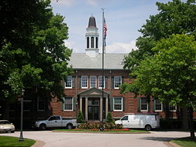 Location of Des Peres, Missouri
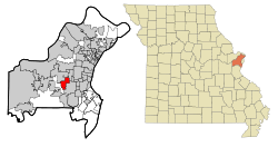
Coordinates: 38°35′46″N 90°26′50″W / 38.59611°N 90.44722°WCoordinates: 38°35′46″N 90°26′50″W / 38.59611°N 90.44722°W Country United States State Missouri County St. Louis Area – Total 4.4 sq mi (11.4 km2) – Land 4.4 sq mi (11.4 km2) – Water 0.0 sq mi (0.0 km2) Elevation 610 ft (186 m) Population (2010) – Total 8,373 – Density 1,902.3/sq mi (734.5/km2) Time zone Central (CST) (UTC-6) – Summer (DST) CDT (UTC-5) FIPS code 29-19270[1] GNIS feature ID 0755986[2] Website Des Peres, Missouri - Official Website Des Peres (French: Des Pères) is a city in St. Louis County, Missouri, United States. The population was 8,373 at the 2010 census.[3]
Contents
History
The first inhabitants of Des Peres were the Cahokia, the Kaskaskia, the Michigamea, the Moingwena, and the Tamaora Native American tribes.[4]
The Osage Tribe lived in the area around Des Peres. The Osage were members of the Dhegiha Sioux group of tribes. This group also included the Ponca tribe, Quapaw tribe, Kansas tribe, and Omaha tribe.
People of European descent began settling in Des Peres in the 1800s. By 1850, there were 75,000 people living in St. Louis. Des Peres was mainly settled by German immigrants and southerners from Virginia and the Carolinas who were drawn to the area by the farmland sold off by the United States government in 80-to-160-acre (32 to 65 ha) tracts.[5]
Des Peres got its name from the River des Peres whose tributaries, Deer Creek and Two Mile Creek, ran through the town. The name Des Peres is a French term which means "of the Fathers".
In 1834 a small church, the Des Peres Presbyterian Church, now known as St. Paul's Lutheran of Des Peres, was built on Maddoy Road, now known as Ballas Road.[6]
Geography
Des Peres is located at 38°35′46″N 90°26′50″W / 38.59611°N 90.44722°W (38.596023, -90.447299),[7] at an altitude of 659 feet (201 m) MSL[citation needed] and in the Central Time Zone.
According to the United States Census Bureau, the city has a total area of 4.4 square miles (11 km2), all land.
Demographics
Historical populations Year Pop. ±% 2000 8,592 — 2010 8,373 −2.5% As of the census[1] of 2000, there were 8,592 people, 3,004 households, and 2,532 families residing in the city. The population density was 1,954.3 inhabitants per square mile (754.0/km²). There were 3,071 housing units at an average density of 698.5 per square mile (269.5/km²). The racial makeup of the city was 96.55% White, 0.79% African American, 0.19% Native American, 1.83% Asian, 0.03% Pacific Islander, 0.15% from other races, and 0.45% from two or more races. Hispanic or Latino of any race were 0.83% of the population.
There were 3,004 households out of which 39.2% had children under the age of 18 living with them, 76.2% were married couples living together, 6.1% had a female householder with no husband present, and 15.7% were non-families. 13.5% of all households were made up of individuals and 7.3% had someone living alone who was 65 years of age or older. The average household size was 2.83 and the average family size was 3.12.
In the city the population was spread out with 27.7% under the age of 18, 5.3% from 18 to 24, 21.5% from 25 to 44, 30.1% from 45 to 64, and 15.4% who were 65 years of age or older. The median age was 42 years. For every 100 females there were 94.1 males. For every 100 females age 18 and over, there were 91.6 males.
The median income for a household in the city was $96,433, and the median income for a family was $106,195. Males had a median income of $79,465 versus $40,563 for females. The per capita income for the city was $40,916. About 0.8% of families and 1.5% of the population were below the poverty line, including 1.5% of those under age 18 and 0.4% of those age 65 or over.
Government
The current head of the Des Peres government is Mayor Rick Lahr. The government includes the following elected officials: Alderman John Pound and Kathleen Gmelich - Ward 1, Alderman Jim Kleinschmidt and Paul Raczkiewitz - Ward 2, Alderman Paul Fingerhut and Jim Doering - Ward 3.[8]
Schools in Des Peres
The public schools serving Des Peres are Parkway School District[9] and Kirkwood R-7 School District.[10]
Private schools of Des Peres are St. Clement of Rome School[11] and St. Paul's Lutheran School.[12]
Economy
The United States headquarters of Edward Jones Investments[13] and Scottrade[14] are located in Des Peres.
Taxes
The City of Des Peres does not assess a real or personal property tax and has not for the past eleven years: 67% School District; 13% Special Schools; 7% St. Louis County; 4% Community College; 4% Zoo/Museum District; 2% County Library; 2% MSD; 1% Sheltered Workshops.[15]
Culture
The city is the birthplace of actress Tracy Posner.
Parks and recreation
Des Peres maintains six separate parks: Des Peres Park, Harwood Park, Pioneer Park, Sugar Creek Park, and the newly opened Phantom Forest and Bittersweet woods.
The Lodge[16] is a community center that includes indoor and outdoor aquatic facilities, fitness center, gymnasium, and meeting rooms.
References
- ^ a b "American FactFinder". United States Census Bureau. http://factfinder.census.gov. Retrieved 2008-01-31.
- ^ "US Board on Geographic Names". United States Geological Survey. 2007-10-25. http://geonames.usgs.gov. Retrieved 2008-01-31.
- ^ "Race, Hispanic or Latino, Age, and Housing Occupancy: 2010 Census Redistricting Data (Public Law 94-171) Summary File (QT-PL), Des Peres city, Missouri". U.S. Census Bureau, American FactFinder 2. http://factfinder2.census.gov. Retrieved October 21, 2011.
- ^ Tribes of the Region at First Contact (1673) accessed December 6, 2007.
- ^ Stolwyk, Carl F. (1976). History of Des Peres, Missouri. Binding Unknown.
- ^ Stolwyk
- ^ "US Gazetteer files: 2010, 2000, and 1990". United States Census Bureau. 2011-02-12. http://www.census.gov/geo/www/gazetteer/gazette.html. Retrieved 2011-04-23.
- ^ City of Des Peres accessed December 7, 2007
- ^ Parkway School District Website
- ^ Kirkwood School District Website
- ^ St. Clement School Website
- ^ St. Paul's Lutheran School Website
- ^ Edward Jones
- ^ Scottrade
- ^ City of Des Peres Where Do My Taxes Go?
- ^ The Lodge webpage
External links
- City of Des Peres official website
- Kirkwood School District
- Parkway School District
- St. Clement School
- St. Paul's Lutheran School
- The Lodge
Categories:- Cities in St. Louis County, Missouri
- Communities on U.S. Route 66


Wikimedia Foundation. 2010.