- Oakville, Missouri
-
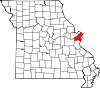
Oakville, Missouri — CDP — Location of Oakville, Missouri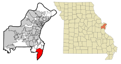
Coordinates: 38°27′31″N 90°19′10″W / 38.45861°N 90.31944°WCoordinates: 38°27′31″N 90°19′10″W / 38.45861°N 90.31944°W Country United States State Missouri County St. Louis Area – Total 18.1 sq mi (46.8 km2) – Land 16.1 sq mi (41.6 km2) – Water 2.0 sq mi (5.2 km2) Elevation 600 ft (183 m) Population (2010) – Total 36,143 – Density 2,000.2/sq mi (772.3/km2) Time zone Central (CST) (UTC-6) – Summer (DST) CDT (UTC-5) US 63129 Area code(s) 314 FIPS code 29-53876[1] GNIS feature ID 0756472[2] Website http://www.oakvillemo.org Oakville is a census-designated place (CDP) in St. Louis County, Missouri, United States. The population was 36,143 at the 2010 census.[3] Oakville is south of the city of St. Louis and borders the Mississippi and Meramec rivers; the area is part of "South County" (south St. Louis County).
Contents
Geography
Oakville is located at 38°27′31″N 90°19′10″W / 38.45861°N 90.31944°W (38.458620, -90.319324)[4]. According to the United States Census Bureau, the CDP has a total area of 18.1 square miles (47 km2), of which 16.1 square miles (42 km2) is land and 2.0 square miles (5.2 km2), or 11.12%, is water.
Demographics
As of the census[1] of 2000, there were 35,309 people, 12,530 households, and 9,923 families residing in the CDP. The population density was 2,196.4 people per square mile (847.8/km²). There were 12,791 housing units at an average density of 795.7 per square mile (307.1/km²). The racial makeup of the CDP was 98.19% White, 0.07% African American, 0.01% Native American, 0.92% Asian, 0.02% Pacific Islander, 0.20% from other races, and 0.60% from two or more races. Hispanic or Latino of any race were 1.03% of the population.
There were 12,530 households out of which 39.1% had children under the age of 18 living with them, 69.6% were married couples living together, 7.0% had a female householder with no husband present, and 20.8% were non-families. 17.3% of all households were made up of individuals and 5.8% had someone living alone who was 65 years of age or older. The average household size was 2.81 and the average family size was 3.20.
In the CDP the population was spread out with 27.0% under the age of 18, 8.9% from 18 to 24, 26.8% from 25 to 44, 27.6% from 45 to 64, and 9.6% who were 65 years of age or older. The median age was 38 years. For every 100 females there were 97.2 males. For every 100 females age 18 and over, there were 94.0 males.
The median income for a household in the CDP was $68,248, and the median income for a family was $76,223 (these figures had risen to $73,027 and $87,568 respectively as of a 2007 estimate[5]). Males had a median income of $52,123 versus $33,604 for females. The per capita income for the CDP was $26,750. About 2.0% of families and 2.8% of the population were below the poverty line, including 3.3% of those under age 18 and 4.0% of those age 65 or over.
Education
Schools
Oakville belongs entirely to the Mehlville School District (R-9) and the St. Louis County Special School District. Oakville High School and Mehlville High School are the two high schools in the Mehlville School District.[6] There are three Catholic grade schools in Oakville: St. Francis of Assisi, Queen of All Saints, and St. Margaret Mary Alacoque.
Community colleges
St. Louis Community College's South County Education and University Center is located off Meramec Bottom Road at Lemay Ferry Road.
Public libraries
The St. Louis County Library Cliff Cave Branch is in Oakville CDP.[7][8]
References
- ^ a b "American FactFinder". United States Census Bureau. http://factfinder.census.gov. Retrieved 2008-01-31.
- ^ "US Board on Geographic Names". United States Geological Survey. 2007-10-25. http://geonames.usgs.gov. Retrieved 2008-01-31.
- ^ "Race, Hispanic or Latino, Age, and Housing Occupancy: 2010 Census Redistricting Data (Public Law 94-171) Summary File (QT-PL), Oakville CDP, Missouri". U.S. Census Bureau, American FactFinder 2. http://factfinder2.census.gov. Retrieved October 26, 2011.
- ^ "US Gazetteer files: 2010, 2000, and 1990". United States Census Bureau. 2011-02-12. http://www.census.gov/geo/www/gazetteer/gazette.html. Retrieved 2011-04-23.
- ^ http://factfinder.census.gov/servlet/ACSSAFFFacts?_event=Search&geo_id=16000US2939044&_geoContext=01000US%7C04000US29%7C16000US2939044&_street=&_county=oakville&_cityTown=oakville&_state=04000US29&_zip=&_lang=en&_sse=on&ActiveGeoDiv=geoSelect&_useEV=&pctxt=fph&pgsl=160&_submenuId=factsheet_1&ds_name=ACS_2007_3YR_SAFF&_ci_nbr=null&qr_name=null®=null%3Anull&_keyword=&_industry=
- ^ "Melhville School District". http://www.mehlvilleschooldistrict.com/wc/default.asp?Info=856968784_1-Schools--0.
- ^ "Cliff Cave Branch." St. Louis County Library. Retrieved on August 18, 2009.
- ^ "Oakville CDP, Missouri." U.S. Census Bureau. Retrieved on August 18, 2009.
Municipalities and communities of St. Louis County, Missouri Cities Ballwin | Bella Villa | Bellefontaine Neighbors | Berkeley | Beverly Hills | Black Jack | Breckenridge Hills | Brentwood | Bridgeton | Charlack | Chesterfield | Clarkson Valley | Clayton | Cool Valley | Country Club Hills | Crestwood | Creve Coeur | Crystal Lake Park | Dellwood | Des Peres | Edmundson | Ellisville | Eureka | Fenton | Ferguson | Flordell Hills | Florissant | Frontenac | Glendale | Greendale | Green Park | Hazelwood | Huntleigh | Jennings | Kinloch | Kirkwood | Ladue | Lakeshire | Manchester | Maplewood | Maryland Heights | Moline Acres | Normandy | Northwoods | Oakland | Olivette | Overland | Pacific‡ | Pagedale | Pasadena Hills | Pine Lawn | Richmond Heights | Rock Hill | Shrewsbury | St. Ann | St. George | St. John | Sunset Hills | Town and Country | University City | Valley Park | Velda City | Vinita Park | Warson Woods | Webster Groves | Wellston | Wildwood | Winchester | Woodson Terrace
Villages Bellerive | Bel-Nor | Bel-Ridge | Calverton Park | Champ | Country Life Acres | Glen Echo Park | Grantwood Village | Hanley Hills | Hillsdale | Mackenzie | Marlborough | Norwood Court | Pasadena Park | Riverview | Sycamore Hills | Twin Oaks | Uplands Park | Velda Village Hills | Vinita Terrace | Westwood | Wilbur Park
CDPs Affton | Castle Point | Concord | Glasgow Village | Lemay | Mehlville | Oakville | Sappington | Spanish Lake
Unincorporated
communitiesAscalon | Carsonville | Glencoe | Grover | Peerless Park | Sherman | Times Beach
Footnotes ‡This populated place also has portions in an adjacent county or counties
Greater St. Louis Topics 
Central city Largest cities
(over 20,000 in 2000)Affton CDP · Alton · Ballwin · Belleville · Chesterfield · Collinsville · East St. Louis · Edwardsville · Ferguson · Florissant · Granite City · Hazelwood · Kirkwood · Maryland Heights · Mehlville CDP · Oakville CDP · O'Fallon, Illinois · O'Fallon, Missouri · Saint Charles · St. Peters · Spanish Lake CDP · University City · Webster Groves · WildwoodLargest towns
and villages
(over 10,000 in 2000)Arnold · Bellefontaine Neighbors · Berkeley · Bridgeton · Cahokia · Clayton · Concord CDP · Crestwood · Creve Coeur · Fairview Heights · Farmington · Festus · Glen Carbon · Godfrey · Jennings · Lake St. Louis · Lemay CDP · Manchester · Overland · St. Ann · Swansea · Town and Country · Washington · Wentzville · Wood RiverMissouri Counties Franklin · Jefferson · Lincoln · St. Charles · Saint Francois · St. Louis City · St. Louis County · Warren · WashingtonIllinois Counties Subregions Categories:- Census-designated places in St. Louis County, Missouri


Wikimedia Foundation. 2010.