- Jersey County, Illinois
-
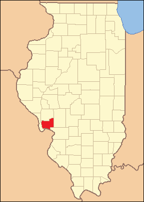
Jersey County, Illinois 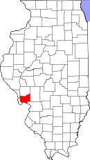
Location in the state of Illinois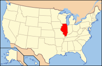
Illinois's location in the U.S.Founded February 28, 1839 Named for U.S. state of New Jersey Seat Jerseyville Largest city Jerseyville Area
- Total
- Land
- Water
377.13 sq mi (977 km²)
369.27 sq mi (956 km²)
7.86 sq mi (20 km²), 2.08%PopulationEst.
- (2010)
- Density
22,985
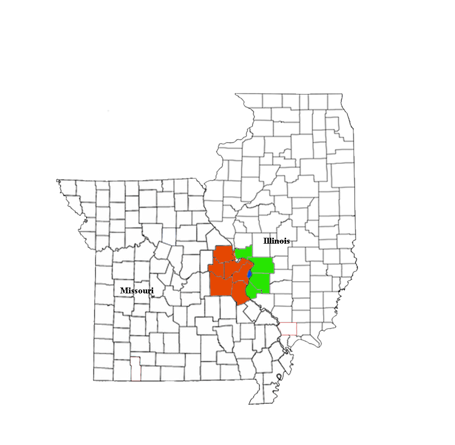
61.3/sq mi (23.7/km²)Time zone Central: UTC-6/-5 Website www.jerseycounty-il.us Jersey County is a county located in the U.S. state of Illinois. Jersey County is part of the St. Louis Metropolitan Area. According to the 2010 census, it has a population of 22,985, which is an increase of 6.1% from 21,668 in 2000.[1] The county seat is Jerseyville.[2]
Contents
Geography
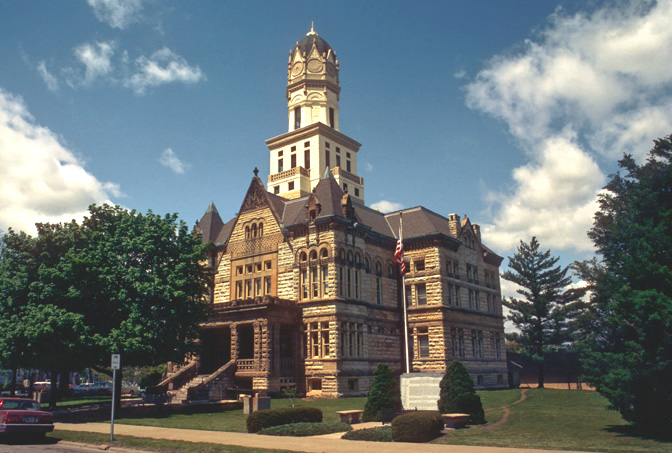
 The Jersey County Courthouse in Jerseyville
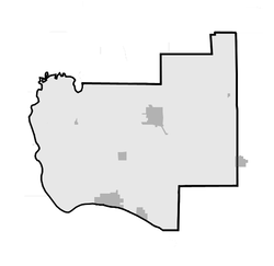
According to the 2010 census, the county has a total area of 377.13 square miles (976.8 km2), of which 369.27 square miles (956.4 km2) (or 97.92%) is land and 7.86 square miles (20.4 km2) (or 2.08%) is water.[3] Jersey County is bordered by three bodies of water: the Mississippi River to the south, the Illinois River to the west, and Macoupin Creek to the northwest.
Climate
Jerseyville, Illinois Climate chart (explanation) J F M A M J J A S O N D 1.93517241223.553324.16442474523.783613.588662.986633.279552.968433.853342.84023Average max. and min. temperatures in °F Precipitation totals in inches Source: The Weather Channel[4] Metric conversion J F M A M J J A S O N D 492-8515-68912010518610023119328168931197430178226137320696121724-5Average max. and min. temperatures in °C Precipitation totals in mm Typically, the county's climate reflects most Midwest areas, located in the transitional zone between the humid continental climate type and the humid subtropical climate type (Koppen Dfa and Cfa, respecively), with neither large mountains nor large bodies of water to moderate its temperature. Spring is the wettest season and produces severe weather ranging from tornadoes to snow or ice storms. Summers are hot and humid, and the humidity often makes the heat index rise to temperatures feeling well above 100 °F (38 °C). Fall is mild with lower humidity and can produce intermittent bouts of heavy rainfall with the first snow flurries usually forming in late November. Winters can be cold at times with periodic light snow and temperatures below freezing.
In recent years, average temperatures in Jerseyville have ranged from a low of 17 °F (−8 °C) in January to a high of 88 °F (31 °C) in July. The record low temperature of −25 °F (−32 °C) was recorded in January 1977 and the record high temperature of 112 °F (44 °C) was recorded in July 1954. Average monthly precipitation ranges from 1.92 inches (49 mm) in January to 4.14 inches (105 mm) in April.[4]
Adjacent counties
- Greene County - north
- Macoupin County - east
- Madison County - southeast
- St. Charles County, Missouri - south
- Calhoun County - west
Major highways
 U.S. Route 67
 Illinois Route 3
 Illinois Route 16
 Illinois Route 100
 Illinois Route 109
 Illinois Route 111
 Illinois Route 267
State protected areas
National protected areas
- Two Rivers National Wildlife Refuge (eastern portion)
History
Historical populations Census Pop. %± 1840 4,535 — 1850 7,354 62.2% 1860 12,051 63.9% 1870 15,054 24.9% 1880 15,542 3.2% 1890 14,810 −4.7% 1900 14,612 −1.3% 1910 13,954 −4.5% 1920 12,682 −9.1% 1930 12,556 −1.0% 1940 13,636 8.6% 1950 15,264 11.9% 1960 17,023 11.5% 1970 18,492 8.6% 1980 20,538 11.1% 1990 20,539 0% 2000 21,668 5.5% 2010 22,985 6.1% Decennial US Census Jersey County lies just northeast of where the great Mississippi and Illinois rivers meet. It is the former home of the Kickapoo, Menomini, Potawatomi, and Illiniwek Confederation American Indians. The first European explorers to visit the area, Father Marquette and Louis Jolliet, arrived in 1673,[5] where they encountered the fearsome painting of the Piasa bird. The present day Pere Marquette State Park, located near Grafton, is named in Father Marquette's honor, and a monument to him is located at the park.
Jersey County was founded on February 28, 1839, and was formed out of Greene County. The county was named for the state of New Jersey, from which many of the early settlers emigrated - which was itself named for the Channel Island of Jersey in Great Britain. The area quickly evolved into several small agricultural communities. As the area soon began to flourish, a county government was established and a courthouse was built in Jerseyville, the county seat. The present courthouse is a magnificent architectural structure that was built in 1893.
Today, while the county maintains its agricultural base, it is also within commuting distance of jobs and industry in St. Louis, Missouri and the surrounding area. A large portion of the population works outside of Jersey County and benefits from being "Near the crowd, but not in it.", the official slogan of the Jersey County Business Association's advertising campaign. The bordering rivers play an important part in Jersey County's economy by supporting agricultural producers and agribusiness, and by creating a strong tourist market. Education, manufacturing, and retail are among the county's largest industries.
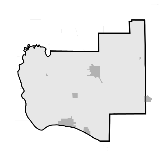
-
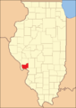
Jersey County at the time of its creation in 1839
Demographics
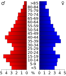 2000 census age pyramid for Jersey County.
As of the census[6] of 2000, there were 21,668 people, 8,096 households, and 5,861 families residing in the county. The population density was 59 people per square mile (23/km²). There were 8,918 housing units at an average density of 24 per square mile (9/km²). The racial makeup of the county was 98.13% White, 0.53% Black or African American, 0.20% Native American, 0.25% Asian, 0.03% Pacific Islander, 0.15% from other races, and 0.70% from two or more races. 0.75% of the population were Hispanic or Latino of any race. 39.2% were of German, 14.5% American, 11.2% Irish and 11.1% English ancestry according to Census 2000. 98.3% spoke English and 1.1% Spanish as their first language.
There were 8,096 households, out of which 34.60% had children under the age of 18 living with them, 60.10% were married couples living together, 9.10% had a female householder with no husband present, and 27.60% were non-families. 23.90% of all households were made up of individuals and 11.80% had someone living alone who was 65 years of age or older. The average household size was 2.57 and the average family size was 3.05.
In the county, the population was spread out with 25.40% under the age of 18, 9.90% from 18 to 24, 27.60% from 25 to 44, 22.80% from 45 to 64, and 14.40% who were 65 years of age or older. The median age was 37 years. For every 100 females there were 95.60 males. For every 100 females age 18 and over, there were 92.40 males.
The median income for a household in the county was $42,065, and the median income for a family was $49,666. Males had a median income of $38,771 versus $23,086 for females. The per capita income for the county was $19,581. About 5.30% of families and 7.10% of the population were below the poverty line, including 8.70% of those under age 18 and 5.70% of those age 65 or over.
Education
Unified school districts
- Alton Community Unit School District 11 - serves a very small portion of southern Jersey County (east of Elsah), along with northwestern Madison County.
- Jersey Community Unit School District 100 - serves most of Jersey County, and a small portion of southern Greene County.
- Southwestern Community Unit School District 9 - serves the northeastern and southeastern portions of Jersey County, along with southwestern Macoupin County.
High Schools
- Jersey Community High School, located in Jerseyville.
Colleges and Universities
- Principia College, located near Elsah.
Municipalities
 Incorporated communities in Jersey County
Cities
Villages
Towns
Townships
Jersey County is divided into eleven townships:
Townships by population
2008 estimates:[7]
- Jersey Township - 9,904
- Piasa Township - 3,109
- Elsah Township - 2,422
- Mississippi Township - 2,037
- Quarry Township - 1,228
- Otter Creek Township - 953
- Richwood Township - 757
- Fidelity Township - 731
- English Township - 548
- Rosedale Township - 499
- Ruyle Township - 434
Unincorporated Areas
- Beltrees
- Chautauqua
- Delhi
- Democrat Spring
- Dow
- East Newbern
- Kemper
- Lake Piasa
- Lockhaven
- McClusky
- Rosedale
- Spankey
See also
References
- ^ "Jersey County QuickFacts". United States Census Bureau. http://quickfacts.census.gov/qfd/states/17/17083.html. Retrieved 2011-11-05.
- ^ "Find a County". National Association of Counties. http://www.naco.org/Counties/Pages/FindACounty.aspx. Retrieved 2011-06-07.
- ^ "Census 2010 U.S. Gazetteer Files: Counties". United States Census. http://www.census.gov/geo/www/gazetteer/files/Gaz_counties_national.txt. Retrieved 2011-11-05.
- ^ a b "Monthly Averages for Jerseyville, Illinois". The Weather Channel. http://www.weather.com/weather/wxclimatology/monthly/graph/USIL0588. Retrieved 2011-01-27.
- ^ Jersey County description & history, retrieved August 24, 2007
- ^ "American FactFinder". United States Census Bureau. http://factfinder.census.gov. Retrieved 2008-01-31.
- ^ Illinois Subcounty population estimates (2008), (XLS format) retrieved August 4, 2009
External links

Greene County Calhoun County 
Macoupin County  Jersey County, Illinois

St. Charles County, Missouri Madison County Municipalities and communities of Jersey County, Illinois Cities 
Town Villages Townships Elsah | English | Fidelity | Jersey | Mississippi | Otter Creek | Piasa | Quarry | Richwood | Rosedale | Ruyle
Unincorporated
communitiesBeltrees | Chautauqua | Delhi | Democrat Spring | Dow | East Newbern | Kemper | Lake Piasa | Lockhaven | McClusky | New Delhi | Newbern | Nutwood | Reardon | Reddish | Rosedale | Spankey
Footnotes ‡ This populated place also has portions in an adjacent county or counties
Greater St. Louis Topics 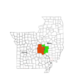
Central city Largest cities
(over 20,000 in 2000)Affton CDP · Alton · Ballwin · Belleville · Chesterfield · Collinsville · East St. Louis · Edwardsville · Ferguson · Florissant · Granite City · Hazelwood · Kirkwood · Maryland Heights · Mehlville CDP · Oakville CDP · O'Fallon, Illinois · O'Fallon, Missouri · Saint Charles · St. Peters · Spanish Lake CDP · University City · Webster Groves · WildwoodLargest towns
and villages
(over 10,000 in 2000)Arnold · Bellefontaine Neighbors · Berkeley · Bridgeton · Cahokia · Clayton · Concord CDP · Crestwood · Creve Coeur · Fairview Heights · Farmington · Festus · Glen Carbon · Godfrey · Jennings · Lake St. Louis · Lemay CDP · Manchester · Overland · St. Ann · Swansea · Town and Country · Washington · Wentzville · Wood RiverMissouri Counties Franklin · Jefferson · Lincoln · St. Charles · Saint Francois · St. Louis City · St. Louis County · Warren · WashingtonIllinois Counties Subregions Illinois Metro-East region Counties 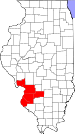
Major Cities (10,000+) Alton | Belleville | Cahokia | Centralia | Collinsville | East St. Louis | Edwardsville | Fairview Heights | Glen Carbon | Godfrey | Granite City | O'Fallon | Swansea | Wood RiverCities (5,000-10,000) Bethalto | Centreville | Columbia | East Alton | Highland | Jerseyville | Maryville | Mascoutah | Pontoon Beach | Shiloh | Staunton | Troy | Washington Park | WaterlooCities (1,000-5,000) Alorton | Aviston | Beckemeyer | Breese | Brighton | Carlyle | Caseyville | Dupo | Fairmont City | Freeburg | Germantown | Hartford | Lebanon | Madison | Marissa | Millstadt | New Athens | New Baden | Rosewood Heights | Roxana | Smithton | South Roxana | Trenton | Valmeyer | Venice | WamacInterstates in the Metro-East Airports/Military Bases List of Colleges in the Metro-East Sports teams based in the Metro East Categories:- Illinois counties
- 1839 establishments in the United States
- Populated places established in 1839
- Jersey County, Illinois
- Metro-East
- Illinois counties on the Mississippi River


Wikimedia Foundation. 2010.