- Coles County, Illinois
-
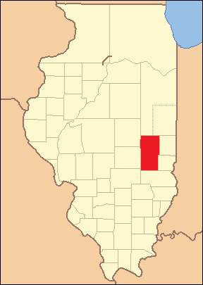
Coles County, Illinois 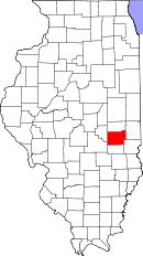
Location in the state of Illinois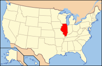
Illinois's location in the U.S.Founded 1831 Seat Charleston Largest city Charleston Area
- Total
- Land
- Water
510.08 sq mi (1,321 km²)
508.29 sq mi (1,316 km²)
1.79 sq mi (5 km²),Population
- (2010)
- Density
53,873
105/sq mi (40/km²)Time zone Central: UTC-6/-5 Website www.co.coles.il.us Coles County is a county located in the U.S. state of Illinois. According to the 2010 census, it has a population of 53,873, which is an increase of 1.3% from 53,196 in 2000.[1] Its county seat is Charleston, which is also the home of Eastern Illinois University.[2]. The county is part of the Charleston–Mattoon Micropolitan Statistical Area.
Contents
History
Coles County was organized in December 1830 out of Clark and Edgar counties. It was named after Edward Coles, the second governor of Illinois from 1822 to 1826.
-

Coles County from the time of its creation to 1843
-
Coles County between 1843 and 1859
-

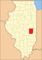
Coles County reduced to its current size in 1859 by the creation of Douglas County
Folklore
Coles County is home to several well-known legends and folktales, including the Mad Gasser of Mattoon and the ghost of Mary Hawkins at Pemberton Hall. Michael Kleen has documented many of these tales, including the "witch's grave" of St. Omer Cemetery and story of "Rag Doll Cemetery," in his book Tales of Coles County, Illinois.[3][4] The legend of "Rag Doll Cemetery" formed the basis of the independent film "Rag Doll," which was filmed primarily in and around Mattoon, Illinois in 2010.[5] Additionally, the novel "A Family Possessed" by L. W. Stevenson is based on poltergeist activity experienced by a rural family living in Coles County in the 1980s.[6] Ashmore Estates has long been a part of local folklore. Originally the almshouse at the Coles County Poor Farm, it is now a haunted attraction and a place of interest for paranormal investigators.[7]
Geography
According to the 2010 census, the county has a total area of 510.08 square miles (1,321.1 km2), of which 508.29 square miles (1,316.5 km2) (or 99.65%) is land and 1.79 square miles (4.6 km2) (or 0.35%) is water.[8]
Adjacent counties
- Douglas County - north
- Edgar County - northeast
- Clark County - southeast
- Cumberland County - south
- Shelby County - southwest
- Moultrie County - west
 Township and municipality map of Coles County.
Major highways
 Interstate 57
 US Route 45
 Illinois Route 16
 Illinois Route 49
 Illinois Route 121
 Illinois Route 130
 Illinois Route 133
Townships
Coles County is divided into these twelve townships:
Settlements
Cities
Villages
Demographics
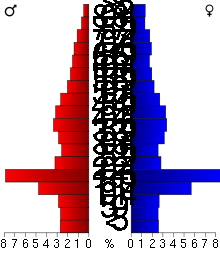 2000 census age pyramid for Coles County, skewed by Eastern Illinois University.
Historical populations Census Pop. %± 1900 34,146 — 1910 34,517 1.1% 1920 35,108 1.7% 1930 37,315 6.3% 1940 38,470 3.1% 1950 40,328 4.8% 1960 42,860 6.3% 1970 47,815 11.6% 1980 52,260 9.3% 1990 51,644 −1.2% 2000 53,196 3.0% IL Counties 1900-1990 As of the census[9] of 2000, there were 53,196 people, 21,043 households, and 12,078 families residing in the county. The population density was 105 people per square mile (40/km²). There were 22,768 housing units at an average density of 45 per square mile (17/km²). The racial makeup of the county was 95.37% White, 2.28% Black or African American, 0.20% Native American, 0.79% Asian, 0.05% Pacific Islander, 0.41% from other races, and 0.90% from two or more races. 1.39% of the population were Hispanic or Latino of any race. 25.4% were of German, 17.8% American, 12.6% English and 12.3% Irish ancestry according to Census 2000. 96.8% spoke English and 1.8% Spanish as their first language.
There were 21,043 households out of which 26.10% had children under the age of 18 living with them, 46.20% were married couples living together, 8.30% had a female householder with no husband present, and 42.60% were non-families. 31.20% of all households were made up of individuals and 11.20% had someone living alone who was 65 years of age or older. The average household size was 2.31 and the average family size was 2.91.
In the county the population was spread out with 19.70% under the age of 18, 23.50% from 18 to 24, 23.80% from 25 to 44, 19.70% from 45 to 64, and 13.30% who were 65 years of age or older. The median age was 31 years. For every 100 females there were 91.30 males. For every 100 females age 18 and over, there were 88.10 males.
The median income for a household in the county was $32,286, and the median income for a family was $45,708. Males had a median income of $32,831 versus $21,923 for females. The per capita income for the county was $17,370. About 7.50% of families and 17.50% of the population were below the poverty line, including 11.40% of those under age 18 and 9.30% of those age 65 or over.
Climate and weather
Charleston, Illinois Climate chart (explanation) J F M A M J J A S O N D 2.235192.441243.45333465434.275523.985614.788653.586633.279563.368453.953343.24024Average max. and min. temperatures in °F Precipitation totals in inches Source: The Weather Channel[10] Metric conversion J F M A M J J A S O N D 562-7615-4851211011861072411100291611831188830178126138320798121824-4Average max. and min. temperatures in °C Precipitation totals in mm In recent years, average temperatures in the county seat of Charleston have ranged from a low of 19 °F (−7 °C) in January to a high of 88 °F (31 °C) in July, although a record low of −27 °F (−33 °C) was recorded in January 1994 and a record high of 110 °F (43 °C) was recorded in July 1936. Average monthly precipitation ranged from 2.20 inches (56 mm) in January to 4.65 inches (118 mm) in July.[10]
See also
References
- United States Census Bureau 2007 TIGER/Line Shapefiles
- United States Board on Geographic Names (GNIS)
- United States National Atlas
- ^ "Coles County QuickFacts". United States Census Bureau. http://quickfacts.census.gov/qfd/states/17/17029.html. Retrieved 2011-11-05.
- ^ "Find a County". National Association of Counties. http://www.naco.org/Counties/Pages/FindACounty.aspx. Retrieved 2011-06-07.
- ^ "Tales of Coles County, Illinois". Black Oak Press, Illinois. 2004, 2010. http://colescountytales.us/.
- ^ "Student author gets creative with Coles history". Daily Eastern News. 28 October 2005. http://www.thedailyeasternnews.com/media/paper309/news/2005/10/28/TheVerge/Student.Author.Gets.Creative.With.Coles.History-1037276.shtml.
- ^ "Mattoon-based thriller gets a name". Journal Gazette/Times-Courier. 14 May 2010. http://jg-tc.com/news/article_b6bfdb2c-5f05-11df-bf17-001cc4c03286.html.
- ^ "A Ghost Story of local proportions". Journal Gazette/Times-Courier. 28 October 2000. http://jg-tc.com/news/article_307eb745-1ff3-5981-a2f7-35cbd24ea576.html.
- ^ "TV team uses technology to root out spirits at Ashmore Estates". Times-Courier. 20 July 2008. http://jg-tc.com/news/article_c0e6c9a9-f45c-50d9-8b4a-cc4a63074e61.html.
- ^ "Census 2010 U.S. Gazetteer Files: Counties". United States Census. http://www.census.gov/geo/www/gazetteer/files/Gaz_counties_national.txt. Retrieved 2011-11-05.
- ^ "American FactFinder". United States Census Bureau. http://factfinder.census.gov. Retrieved 2008-01-31.
- ^ a b "Monthly Averages for Charleston, Illinois". The Weather Channel. http://www.weather.com/weather/wxclimatology/monthly/graph/USIL0214. Retrieved 2011-01-27.
External links
- Coles County Online Community
- Official Coles County website
- Tales of Coles County, Illinois
- Illinois State Archives

Douglas County Edgar County Moultrie County 
 Coles County, Illinois

Shelby County Cumberland County Clark County Municipalities and communities of Coles County, Illinois County seat: Charleston Cities Charleston | Mattoon | Oakland

Villages Townships Ashmore | Charleston | East Oakland | Humboldt | Hutton | Lafayette | Mattoon | Morgan | North Okaw | Paradise | Pleasant Grove | Seven Hickory
Unincorporated
communitiesFootnotes ‡This populated place also has portions in an adjacent county or counties
Categories:- Illinois counties
- 1831 establishments in the United States
- Populated places established in 1831
- Coles County, Illinois
- Charleston-Mattoon micropolitan area
-


Wikimedia Foundation. 2010.