- Williamson County, Illinois
-
Williamson County, Illinois 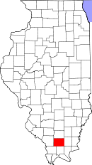
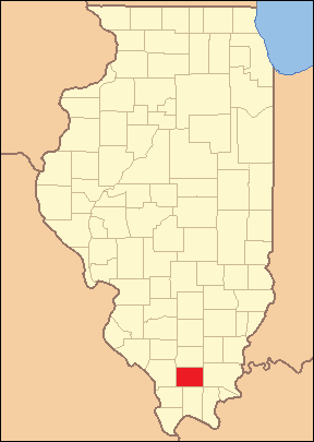
Location in the state of Illinois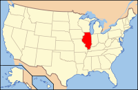
Illinois's location in the U.S.Founded 1839 Seat Marion Largest city Marion Area
- Total
- Land
- Water
444.35 sq mi (1,151 km²)
420.15 sq mi (1,088 km²)
24.20 sq mi (63 km²), 5.45%Population
- (2010)
- Density
66,357
145/sq mi (56/km²)Time zone Central: UTC-6/-5 Williamson County is a county located in the southern part of the U.S. state of Illinois in the area known as Little Egypt. In the 19th century it was the site of a ten-year long feud known as the Bloody Vendetta that claimed many lives. According to the 2010 census, it has a population of 66,357, which is an increase of 8.3% from 61,296 in 2000.[1] Its county seat is Marion.[2] Williamson is a rapidly growing county in the Metro Lakeland area and is located 88 miles (142 km) southeast of St. Louis, MO. Its location at the intersection of Interstate 57, Interstate 24, and Illinois Route 13, a main east-west 4-lane expressway, gives it access to the major communities of Murphysboro, Carbondale, Carterville, Herrin, Marion, and Harrisburg, IL. Although the Williamson County population is only 66,357, it is located in the heart of the Metro Lakeland area of Jackson-Williamson Counties where 120,000 citizens of Illinois make their home. Carbondale (14 miles west), Herrin and Marion are the key urban areas in Metro Lakeland, with a combined population of over 65,000. Over 235,000 people live within 35 miles (56 km).
Contents
Geography
According to the 2010 census, the county has a total area of 444.35 square miles (1,150.9 km2), of which 420.15 square miles (1,088.2 km2) (or 94.55%) is land and 24.20 square miles (62.7 km2) (or 5.45%) is water.[3]
Major highways
 Interstate 24
 Interstate 57
 U.S. Highway 45
 Illinois Route 13
 Illinois Route 37
 Illinois Route 148
 Illinois Route 149
 Illinois Route 166
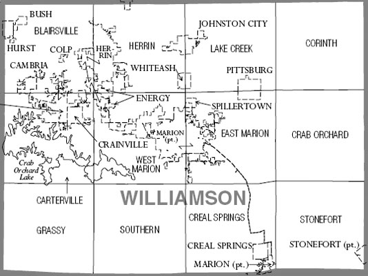
Precinct map
Adjacent counties
- Franklin County (north)
- Saline County (east)
- Pope County (southeast)
- Johnson County (south)
- Union County (southwest)
- Jackson County (west)
National protected area
Demographics
Historical populations Census Pop. %± 1840 4,457 — 1850 7,216 61.9% 1860 12,205 69.1% 1870 17,329 42.0% 1880 19,324 11.5% 1890 22,226 15.0% 1900 27,796 25.1% 1910 45,098 62.2% 1920 61,092 35.5% 1930 53,880 −11.8% 1940 51,424 −4.6% 1950 48,621 −5.5% 1960 46,117 −5.2% 1970 49,021 6.3% 1980 56,538 15.3% 1990 57,733 2.1% 2000 61,296 6.2% 2010 66,357 8.3% UVa Census Browser 1840-1890[4]
Illinois Counties 1900-1990[5]2010
Whereas according to the 2010 U.S. Census Bureau:
- 92.7% White
- 3.8% Black
- 0.4% Native American
- 0.8% Asian
- 0.0% Native Hawaiian or Pacific Islander
- 1.7% Two or more races
- 0.4% Other races
- 2.0% Hispanic or Latino (of any race)
2000
As of the census[6] of 2000, there were 61,296 people, 25,358 households, and 16,964 families residing in the county. The population density was 145 people per square mile (56/km²). There were 27,703 housing units at an average density of 65 per square mile (25/km²). The racial makeup of the county was 95.34% White, 2.49% Black or African American, 0.27% Native American, 0.50% Asian, 0.03% Pacific Islander, 0.38% from other races, and 0.98% from two or more races. 1.24% of the population were Hispanic or Latino of any race. 18.1% were of German, 18.1% American, 13.7% English, 12.9% Irish and 6.6% Italian ancestry according to Census 2000.
There were 25,358 households out of which 29.50% had children under the age of 18 living with them, 53.40% were married couples living together, 10.20% had a female householder with no husband present, and 33.10% were non-families. 28.90% of all households were made up of individuals and 13.30% had someone living alone who was 65 years of age or older. The average household size was 2.35 and the average family size was 2.89.
In the county the population was spread out with 22.90% under the age of 18, 8.60% from 18 to 24, 27.90% from 25 to 44, 24.10% from 45 to 64, and 16.50% who were 65 years of age or older. The median age was 39 years. For every 100 females there were 93.90 males. For every 100 females age 18 and over, there were 91.70 males.
The median income for a household in the county was $31,991, and the median income for a family was $40,692. Males had a median income of $32,386 versus $21,570 for females. The per capita income for the county was $17,779. About 11.40% of families and 14.60% of the population were below the poverty line, including 19.60% of those under age 18 and 10.60% of those age 65 or over.
Political subdivisions
Cities and Villages
Unincorporated communities
- Corinth
- Crab Orchard
- Crenshaw
- Dewmaine
- Dykersburg
- Lake of Egypt
- No. 9
- Paulton
- Pulley's Mill
Formerly populated places (ghost towns)
Precincts
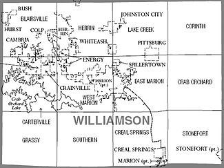
The following precincts are not voting precincts, but represent the 12 Congressional townships in Williamson County. Most have multiple voting precincts.
- Blairsville
- Carterville
- Corinth
- Crab Orchard
- Creal Springs
- East Marion
- Grassy
- Herrin
- Lake Creek
- Southern
- Stonefort
- West Marion
History
Williamson County was formed out of Franklin County on February 28, 1839, and was named for Williamson County, Tennessee.[7]
-
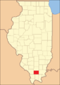
Williamson County at the time of its creation in 1839
Williamson County is often referred to as "Bloody Williamson" due to several outbreaks of violence that have few parallels in American history.[8] These include the following: the Bloody Vendetta, 1876; the Carterville Massacre, 1899; Coal Strike, 1906; The Herrin Massacre, 1922; the Klan War, 1924–1926; the Birger/Shelton Gang War, 1926.
The Illinois National Guard was deployed repeatedly during the 1920s to separate the warring parties and attempt to keep order.
As with the entire United States, severe weather in Williamson County is not uncommon. The northwest section of the county was obliterated by the Tri-State Tornado of 1925. The county was also struck by 2 tornadoes on May 29, 1982 killing 10 people in the Marion, Illinois tornado outbreak. On May 8, 2009, the cities of Carterville, Herrin, and Marion were severely damaged by the May 2009 Southern Midwest derecho.
Government and infrastructure
United States Penitentiary, Marion is located in Southern Precinct in Williamson County.[9][10]
Transportation
Williamson County Regional Airport is an airport.
Climate and weather
Marion, Illinois Climate chart (explanation) J F M A M J J A S O N D 3.338193.244234.555334.566424.975524.383613.987653.786633.179553.168434.855343.74324Average max. and min. temperatures in °F Precipitation totals in inches Source: The Weather Channel[11] Metric conversion J F M A M J J A S O N D 833-7817-51131311151961252411110281699311894301780261378206121131946-4Average max. and min. temperatures in °C Precipitation totals in mm Williamson County lies on the border between humid continental climate (Koppen climate classification Dfa) and humid subtropical climate (Koppen climate classification Cfa), with neither large mountains nor large bodies of water to moderate its temperature. It is subject to both cold Arctic air and hot, humid tropical air from the Gulf of Mexico and, along with the rest of the midwestern United States, is home to some of the largest temperature extremes in the world. The region has four distinct seasons. Spring is the wettest season and produces erratic severe weather ranging from tornadoes to winter storms. Summers are hot and humid with only occasional and brief respite, and the humidity often makes the heat index rise to temperatures feeling well above 100 °F (38 °C). Fall is mild with lower humidity and can produce intermittent bouts of heavy rainfall with the first snow flurries usually forming in late November. Winters are cold with periodic snow and temperatures often below freezing, however thaws are usually frequent. Winter storm systems, such as Alberta Clippers and Panhandle hooks, can bring days of heavy freezing rain, ice pellets, and snowfall.
The normal high temperature in July is 90 °F (32 °C), and the normal low temperature in January is 19 °F (−6 °C), although this varies from year to year. Both 100 °F (37.8 °C) and 0 °F (−17.8 °C) temperatures can be seen on an average 2 or 3 days per year. In recent years, average temperatures have ranged from a low of 19 °F (−7 °C) in January to a high of 88 °F (31 °C) in July, although a record low of −25 °F (−32 °C) was recorded in January 1977 and a record high of 113 °F (45 °C) was recorded in August 1977. Average monthly precipitation ranged from 3.06 inches (78 mm) in October to 4.93 inches (125 mm) in May.[11]
Williamson County experiences thunderstorms about 50 days a year on average. Thunderstorms contribute over half of the annual precipitation. Especially in the spring, these storms can often be severe, with high winds, large hail and tornadoes.
Some late autumns feature the warm weather known as Indian summer; some years see roses in bloom as late as early December.
See also
References
- ^ "Williamson County QuickFacts". United States Census Bureau. http://quickfacts.census.gov/qfd/states/17/17199.html. Retrieved 2011-11-05.
- ^ "Find a County". National Association of Counties. http://www.naco.org/Counties/Pages/FindACounty.aspx. Retrieved 2011-06-07.
- ^ "Census 2010 U.S. Gazetteer Files: Counties". United States Census. http://www.census.gov/geo/www/gazetteer/files/Gaz_counties_national.txt. Retrieved 2011-11-05.
- ^ Historical Census Browser, University of Virginia, Geospacial and Statistical Data Center, 2004, http://fisher.lib.virginia.edu/collections/stats/histcensus/index.html
- ^ Illinois Counties 1900-1990, U.S. Census Bureau, http://www.census.gov/population/cencounts/il190090.txt
- ^ "American FactFinder". United States Census Bureau. http://factfinder.census.gov. Retrieved 2008-01-31.
- ^ Adams, James N. (compiler) (1989), Keller, William E., ed., Illinois Place Names, Springfield: Illinois State Historical Society, pp. 609, ISBN 0912226242
- ^ Angle, Paul M. (1992), Bloody Williamson - A Chapter in American Lawlessness, University of Illinois Press, ISBN 0-252-06233-7
- ^ "USP Marion Contact Information." Federal Bureau of Prisons. Retrieved on June 5, 2010.
- ^ "Marion city, Illinois." U.S. Census Bureau. Retrieved on June 5, 2010.
- ^ a b "Monthly Averages for Marion, Illinois". The Weather Channel. http://www.weather.com/weather/wxclimatology/monthly/graph/USIL0727. Retrieved 2011-01-27.
Further reading
- Angle, Paul M. (1992). Bloody Williamson - A Chapter in American Lawlessness. University of Illinois Press. ISBN 0-252-06233-7.
- Ayabe, Masatomo, “Ku Kluxers in a Coal Mining Community: A Study of the Ku Klux Klan Movement in Williamson County, Illinois, 1923–1926,” Journal of the Illinois State Historical Society, 102 (Spring 2009), 73–100.
- Erwin, Milo. 1876, Rep. 1976. History of Williamson County, Illinois. Marion, Ill.: Williamson County Historical Society.
- Erwin, Milo, and Jon Musgrave. 2006. The Bloody Vendetta of Southern Illinois. Marion, Ill.: IllinoisHistory.com. 240 pages.
- Johnson, Ralph, and Jon Musgrave. 2010. Secrets of the Herrin Gangs. Marion, Ill.: IllinoisHistory.com. 96 pages.

Franklin County Jackson County 
Saline County  Williamson County, Illinois

Union County Johnson County Pope County Municipalities and communities of Williamson County, Illinois County seat: Marion Cities Carterville | Creal Springs | Herrin | Hurst | Johnston City | Marion‡

Villages Bush | Cambria | Colp | Crainville | Energy | Freeman Spur‡ | Pittsburg | Spillertown | Stonefort‡ | Whiteash
Precincts Blairsville | Carterville | Corinth | Crab Orchard | Creal Springs | East Marion | Grassy | Herrin | Lake Creek | Southern | Stonefort | West Marion
Unincorporated
communitiesAttila | Blairsville | Chittyville | Clifford | Corinth | Crab Orchard | Crenshaw Crossing | Dewmaine | Dykersburg | Egyptian Hills | Egyptian Shores | Ferges | Fergestown | Hafer | Lake Crest | New Camp | No. 9 | Old Camp | Paulton | Paineville | Pulleys Mill | Shakerag
Ghost towns Chamness | Halfway | Halfway (Little Juarez)
Footnotes ‡This populated place also has portions in an adjacent county or counties
Categories:- Illinois counties
- 1839 establishments in the United States
- Populated places established in 1839
- Williamson County, Illinois
- Little Egypt
- Metro Lakeland


Wikimedia Foundation. 2010.