- Macon County, Illinois
-
Macon County, Illinois 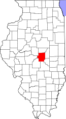
Location in the state of Illinois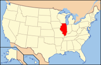
Illinois's location in the U.S.Founded 1829 Seat Decatur Area
- Total
- Land
- Water
585.86 sq mi (1,517 km²)
580.69 sq mi (1,504 km²)
5.18 sq mi (13 km²), 0.88%Population
- (2010)
- Density
110,768
198/sq mi (76/km²)Time zone Central: UTC-6/-5 Website www.maconcounty-il.gov Macon County is a county located in the U.S. state of Illinois and is included in the Decatur, Illinois, Metropolitan Statistical Area. According to the 2010 census, it has a population of 110,768, which is a decrease of 3.4% from 114,706 in 2000.[1] Its county seat is Decatur.[2]
Contents
Geography
According to the 2010 census, the county has a total area of 585.86 square miles (1,517.4 km2), of which 580.69 square miles (1,504.0 km2) (or 99.12%) is land and 5.18 square miles (13.4 km2) (or 0.88%) is water.[3]
Because of its location, Macon County is often referred to as "The Heart of Illinois"[citation needed]. However, it's not actually in the center of the State.
Major highways
 Interstate 72
 U.S. Highway 51
 U.S. Highway 36
 Illinois Route 48
 Illinois Route 105
 Illinois Route 121
 Illinois Route 128
Townships
Austin, Blue Mound, Decatur, Friends Creek, Harristown, Hickory Point, Illini, Long Creek, Maroa, Milam, Mount Zion, Niantic, Oakley, Pleasant View, South Macon, South Wheatland, Whitmore
Adjacent counties
- De Witt County - north
- Piatt County - northeast
- Moultrie County - southeast
- Shelby County - south
- Christian County - southwest
- Sangamon County - west
- Logan County - northwest
History
Macon County was formed on January 19, 1829 out of Shelby County. It was named for Nathaniel Macon, who served as a Colonel in the Revolutionary War. Macon later served as United States Senator from North Carolina until his resignation in 1828.
-
Macon County from the time of its creation to 1839
-

Macon County between 1839 and 1841
-

Macon County between 1841 and 1843
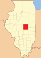
-

Macon County in 1843, reduced to its present borders
Demographics
Historical populations Census Pop. %± 1900 44,003 — 1910 54,186 23.1% 1920 65,175 20.3% 1930 81,731 25.4% 1940 84,693 3.6% 1950 98,853 16.7% 1960 118,257 19.6% 1970 125,010 5.7% 1980 131,375 5.1% 1990 117,206 −10.8% 2000 114,706 −2.1% IL Counties 1900-1990 As of the census[4] of 2000, there were 114,706 people, 46,561 households, and 30,963 families residing in the county. The population density was 198 people per square mile (76/km²). There were 50,241 housing units at an average density of 86 per square mile (33/km²). The racial makeup of the county was 83.48% White, 14.06% Black or African American, 0.17% Native American, 0.57% Asian, 0.02% Pacific Islander, 0.33% from other races, and 1.36% from two or more races. 0.98% of the population were Hispanic or Latino of any race. 23.8% were of German, 15.9% American, 10.7% English and 9.9% Irish ancestry according to Census 2000.
There were 46,561 households out of which 29.60% had children under the age of 18 living with them, 50.70% were married couples living together, 12.20% had a female householder with no husband present, and 33.50% were non-families. 28.80% of all households were made up of individuals and 11.60% had someone living alone who was 65 years of age or older. The average household size was 2.39 and the average family size was 2.93.
In the county the population was spread out with 24.60% under the age of 18, 9.80% from 18 to 24, 26.40% from 25 to 44, 24.00% from 45 to 64, and 15.20% who were 65 years of age or older. The median age was 38 years. For every 100 females there were 91.20 males. For every 100 females age 18 and over, there were 87.50 males.
The median income for a household in the county was $37,859, and the median income for a family was $47,493. Males had a median income of $39,107 versus $22,737 for females. The per capita income for the county was $20,067. About 9.30% of families and 12.90% of the population were below the poverty line, including 19.00% of those under age 18 and 8.20% of those age 65 or over.
Cities and towns
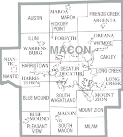 Map of Macon County, Illinois.
- Argenta
- Bearsdale
- Blue Mound
- Decatur
- Emery
- Forsyth
- Harristown
- Long Creek
- Macon
- Maroa
- Mount Zion
- Newburg
- Niantic
- Oakley
- Oreana
- Warrensburg
Climate and weather
Decatur, Illinois Climate chart (explanation) J F M A M J J A S O N D 2.13517241223.253323.665424.576523.985614.588654.18663380552.768443.352342.93923Average max. and min. temperatures in °F Precipitation totals in inches Source: The Weather Channel[5] Metric conversion J F M A M J J A S O N D 522-8505-681120911861142411992916115311810530177627137020784111734-5Average max. and min. temperatures in °C Precipitation totals in mm In recent years, average temperatures in the county seat of Decatur have ranged from a low of 17 °F (−8 °C) in January to a high of 88 °F (31 °C) in July, although a record low of −25 °F (−32 °C) was recorded in February 1905 and a record high of 113 °F (45 °C) was recorded in July 1954. Average monthly precipitation ranged from 1.95 inches (50 mm) in February to 4.54 inches (115 mm) in July.[5]
See also
References
- ^ "Macon County QuickFacts". United States Census Bureau. http://quickfacts.census.gov/qfd/states/17/17115.html. Retrieved 2011-11-05.
- ^ "Find a County". National Association of Counties. http://www.naco.org/Counties/Pages/FindACounty.aspx. Retrieved 2011-06-07.
- ^ "Census 2010 U.S. Gazetteer Files: Counties". United States Census. http://www.census.gov/geo/www/gazetteer/files/Gaz_counties_national.txt. Retrieved 2011-11-05.
- ^ "American FactFinder". United States Census Bureau. http://factfinder.census.gov. Retrieved 2008-01-31.
- ^ a b "Monthly Averages for Decatur, Illinois". The Weather Channel. http://www.weather.com/weather/wxclimatology/monthly/graph/USIL0302. Retrieved 2011-01-27.

Logan County De Witt County Piatt County Sangamon County 
 Macon County, Illinois

Christian County Shelby County Moultrie County Municipalities and communities of Macon County, Illinois Cities 
Villages Argenta | Blue Mound | Forsyth | Harristown | Long Creek | Mount Zion | Niantic | Oreana | Warrensburg
Townships Austin | Blue Mound | Decatur | Friends Creek | Harristown | Hickory Point | Illini | Long Creek | Maroa | Mt. Zion | Niantic | Oakley | Pleasant View | South Macon | South Wheatland | Whitmore
Unincorporated
communitiesBearsdale | Blackland | Boody | Bulldog Crossing | Casner | Elwin | Emery | Heman | Hervey City | Newburg | Oakley | Prairie Hall | Sangamon | Turpin | Walker | Wyckles
Ghost towns Chapin | Faries Park
Categories:- Illinois counties
- Macon County, Illinois
- 1829 establishments in the United States
- Populated places established in 1829


Wikimedia Foundation. 2010.