- North Okaw Township, Coles County, Illinois
-
North Okaw Township — Township — Location in Coles County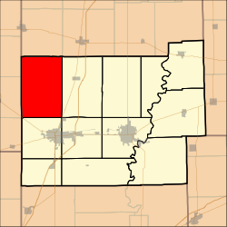 Coles County's location in Illinois
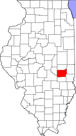
Coordinates: 39°35′10″N 88°25′03″W / 39.58611°N 88.4175°WCoordinates: 39°35′10″N 88°25′03″W / 39.58611°N 88.4175°W Country United States State Illinois County Coles Established November 8, 1859 Area – Total 54.42 sq mi (140.94 km2) – Land 54.37 sq mi (140.83 km2) – Water 0.04 sq mi (0.11 km2) 0.08% Elevation 653 ft (199 m) Population (2000) – Total 918 – Density 16.9/sq mi (6.5/km2) Time zone CST (UTC-6) – Summer (DST) CDT (UTC-5) ZIP codes 61910, 61911, 61931, 61938, 61951 GNIS feature ID 0429462 North Okaw Township is one of twelve townships in Coles County, Illinois, USA. As of the 2000 census, its population was 918[1]. The Kaskaskia River flows through the township. The Cook Mills Consolidated oil field is within this township. The township changed its name from Okaw Township on May 7, 1860.
Contents
Geography
According to the United States Census Bureau, North Okaw Township covers an area of 54.42 square miles (140.9 km2); of this, 0.04 square miles (0.10 km2) or 0.08 percent is water.
Unincorporated towns
(This list is based on USGS data and may include former settlements.)
Cemeteries
The township contains these five cemeteries: Brann, Mount Zion, Pleasant Grove, Smith and Zoar.
Major highways
 US Route 45
 Illinois Route 121
School districts
- Arcola Consolidated Unit School District 306
- Arthur Community Unit School District 305
- Mattoon Community Unit School District 2
- Sullivan Community Unit School District 300
Political districts
- Illinois' 15th congressional district
- State House District 110
- State Senate District 55
References
- "North Okaw Township, Coles County, Illinois". Geographic Names Information System, U.S. Geological Survey. http://geonames.usgs.gov/pls/gnispublic/f?p=gnispq:3:::NO::P3_FID:0429462. Retrieved 2010-01-10.
- United States Census Bureau 2007 TIGER/Line Shapefiles
- United States National Atlas
External links
Municipalities and communities of Coles County, Illinois Cities Charleston | Mattoon | Oakland

Villages Townships Ashmore | Charleston | East Oakland | Humboldt | Hutton | Lafayette | Mattoon | Morgan | North Okaw | Paradise | Pleasant Grove | Seven Hickory
Unincorporated
communitiesFootnotes ‡This populated place also has portions in an adjacent county or counties
Categories:- Townships in Coles County, Illinois


Wikimedia Foundation. 2010.