- Jackson County, Missouri
-
Jackson County, Missouri 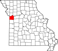
Location in the state of Missouri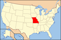
Missouri's location in the U.S.Founded December 15, 1826 Seat Independence Area
- Total
- Land
- Water
616.41 sq mi (1,596 km²)
604.84 sq mi (1,567 km²)
11.57 sq mi (30 km²), 1.88%Population
- (2010)
- Density
674,158
1,114/sq mi (430.22/km²)Website www.jacksongov.org Jackson County is a county located in the U.S. state of Missouri. With a population of 674,158 in the 2010 census, Jackson County is the second most populous of Missouri's counties, after St. Louis County.[1] Kansas City, the state's most populous city and focus city of the Kansas City Metropolitan Area, is partly located in Jackson County. Although Independence retains its status as the original county seat, Kansas City serves as a second county seat and the center of county government.[2]
Contents
History
Early years
Jackson County was home to members of the Osage Indian tribe. The first known European explorers were French trappers who used the Missouri River as a highway for exploration and trading with Native American tribes. Jackson County was a part of New France, until the British victory in the French and Indian War in 1763 resulted in the cession of this territory to Great Britain's ally, Spain. Spain was forced to return its Louisiana Territory (of which modern Jackson County then formed a part) to France in the Third Treaty of San Ildefonso in 1800, which in turn sold it to the United States in the Louisiana Purchase of 1803.
Explorers Merriwether Lewis and William Clark passed through Jackson County on their famous Lewis and Clark expedition in 1804. Among other items, their report indicated a "high, commanding position" along the river within the current boundaries of Jackson County that in 1808 became Fort Osage. This stockade and trading post was one of the first U.S. military installations within the Louisiana purchase territory, and remained active until 1822.
In 1821, Jackson County became part of the newly-admitted state of Missouri. Jackson County was organized on December 15, 1826 and named for Andrew Jackson, U.S. Senator (and later President) from Tennessee. Its county seat was designated as Independence, which was at the time only a minuscule settlement near a spring. However, the rapid increase in Westward exploration and expansion ultimately made Independence the starting point for three of the great Westward Trails: the Santa Fe Trail, the Oregon Trail and the California Trail. With the American Civil War and the coming of the railroads, nearby Kansas City ultimately eclipsed Independence, though both towns remain county seats.
In 1838, a small piece of land was bought along the Missouri River in northern Jackson County by the "Town Company", which established "Westport Landing" (today the River Market district). The area outside of Westport Landing was renamed the "Town of Kansas," after the local Kanza Indians, in 1839. The town was chartered by Jackson County in 1850 and incorporated by the State of Missouri as the "City of Kansas" in 1853. In 1889, with a population of around 60,000, the city adopted a new charter and changed its name to Kansas City. In 1897, Kansas City annexed Westport.
Latter Day Saints
Jackson County figures prominently in the history of the Latter Day Saint movement. Beginning in March 1831, Church founder Joseph Smith, Jr. claimed that a location on the Missouri-Kansas border was to be a latter-day "New Jerusalem"[3] with the "center place" located in Independence, the County Seat.[4] Traveling to the area in the Summer of 1831, Smith and some associates formally proclaimed Jackson County as the site, in a ceremony in August 1831.[5]
- "Joseph Smith was then told that the members of the Church should buy as much land as possible west from Independence up to the line that designated the land of the Native Americans. Learning that Jackson County Missouri was Zion meant much to Joseph Smith and the members of the Mormon Church. According to Mormon belief, Zion is a place where the pure in heart live. This can mean that Zion can be anywhere, but when God referred to Jackson County as Zion he also told Joseph that this land would be the New Jerusalem.
- "...The saints were eager to begin building up Zion so that they could further the preparations for the coming of Christ.
- "After receiving this revelation, Joseph began making arrangements to build up a city. On August 2, 1831, he helped lay the logs for the first house built in Zion. The first log was carried and placed by twelve men to represent the twelve tribes of Israel. Sidney Rigdon also was asked to dedicate and consecrate the land for the gathering of the Saints..."[6]
Many members (including notable members—Joseph Smith and Brigham Young among them) of the mainline LDS Church, past and present, have believed that Jackson County was the site of the biblical Garden of Eden.[7]
Although formed in upstate New York in 1830, the LDS church leadership and members began moving to Jackson County as soon as word of the August 1831 dedication ceremony was published. Open conflict with earlier settlers ensued, driven by religious and cultural differences, and the perception by pro-slavery Missourians that the "Yankee" "Mormons" were abolitionists.[8] Vigilantes in the public and private sector used force to drive individual Saints from Jackson to nearby counties within Missouri; eventually, Latter Day Saints were given until the end of November 6, 1833 to leave the county en masse.[9] On November 23, 1833, the few remaining Mormon residents were ordered to leave Jackson County.[10] By mid-1839, following the Missouri Mormon War, Mormons were driven from the state altogether, not to return to Jackson County or Missouri in significant numbers until 1867.
Today several Latter Day Saint churches are represented in Jackson County, most notably the Community of Christ, the LDS Church, the Church of Christ (Temple Lot) and the Church of Christ with the Elijah Message—the first and last two of these have their worldwide headquarters there. Joseph Smith prophesied that a temple would be built in Independence "in this generation". The Community of Christ remains the only Latter Day Saint organization (as of 2010) to have a temple in the city on the 66 acres (270,000 m2) originally designated by Smith. Smith's original temple site, a smaller five-acre section within that 66 acres (containing stones originally placed by Smith to mark the corners of his intended structure), is currently owned by the Church of Christ (Temple Lot), which hopes to build a temple of its own sometime in the future.
Although plans were recently announced to construct an LDS temple in adjacent Clay County, the LDS Church still believes that a temple will also be built on the Independence Temple Lot (currently owned by the Temple Lot church) at some future time. An LDS visitors' center is currently situated adjacent to the Temple Lot, with the Community of Christ temple directly across the street.
Civil War
During the Civil War, Jackson County was the scene of several engagements, the most notable of which was the Battle of Westport, sometimes referred to as "the Gettysburg of Missouri," in 1864. The decisive Union victory here firmly established Northern control of Missouri, and led to the failure of Confederate General Sterling Price's Missouri expedition. Other noteworthy battles were fought in Independence in 1862, Lone Jack a few days later, and again in Independence in 1864. All three battles resulted in Confederate victories.
Jackson County was heavily affected by Union General Thomas Ewing's infamous General Order No. 11 (1863). With large numbers of Confederate sympathisers living within its boundaries, and active Confederate operations in the area a frequent occurrence, the Union command was determined to deprive Confederate bushwhackers of all local support. Ewing's decree practically emptied the rural portions of the county, and resulted in the burning of large portions of Jackson and adjacent counties. According to American artist George Caleb Bingham, himself a resident of Kansas City at the time, one could see the "dense columns of smoke arising in every direction", symbolic of what he termed "a ruthless military despotism which spared neither age, sex, character, nor condition". The legacy of Ewing's "imbecilic" (according to Bingham) order haunted Jackson County for decades after the war.
Twentieth century

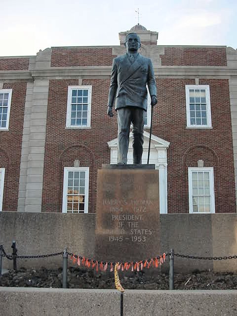
The coming of the railroads and the building of stockyards led to the rapid expansion of Kansas City in the late 19th century. During the 1920s and 30s, the city became a noted center for Jazz and Blues music, as well as the headquarters of Hallmark Cards and the location of Walt Disney's first animation studio. The county fared better than many during the Great Depression, as local political boss Thomas Pendergast worked for implementation of a $50,000,000 public works project that provided thousands of jobs (and a great deal of money for the corrupt Pendergast). One of Pendergast's political proteges was a young World War I veteran from Independence: Harry S. Truman, who went on to become the thirty-third President of the United States in 1944.
Suburban sprawl became a part of Jackson County's landscape following World War II, as returning soldiers and other workers moved into new homes being built in subdivisions that increasingly encroached on rural portions of the county. Independence, Blue Springs and Lee's Summit experienced growth during this period, which continues to the present. Kansas City, on the other hand, experienced the same problems with urban decay afflicting many large American cities during this time. Recent building projects have sought to reverse this trend, including work on the city's famous City Market, the Westport district, the 18th and Vine Historic District and most recently the Kansas City Power & Light District.[11]
Law and government
Jackson County was the second county to adopt a home-rule charter under the Missouri constitution. The Jackson County Charter was adopted by the voters in 1970 and was amended in 1985 and 1986.
Executive power of the county is vested in the county executive, which is a full-time salaried position. The county executive is elected by the general population of the county for a four year term.
Ordinances are passed by a county legislature. The legislature is made up of nine members, six elected from smaller districts within the county and three elected "at large" from larger districts by voters of the whole county. Member terms are 4 years, beginning on January 1 following the election.
There are 244,570 registered voters.[12]
Geography
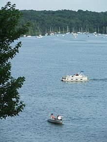 Lake Jacomo
According to the 2000 census, the county has a total area of 616.41 square miles (1,596.5 km2), of which 604.84 square miles (1,566.5 km2) (or 98.12%) is land and 11.57 square miles (30.0 km2) (or 1.88%) is water.[13]
The Missouri River comprises Jackson County's northern border. The county has historically been a major traveling point for American river travel.
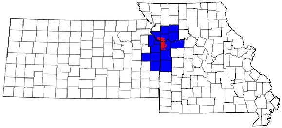
Adjacent counties
- Clay County (north)
- Ray County (north-east)
- Lafayette County (east)
- Johnson County (south-east)
- Cass County (south)
- Johnson County, Kansas (south-west)
- Wyandotte County, Kansas (north-west)
Major highways
 Interstate 29
 Interstate 35
 Interstate 70
 Interstate 435
 Interstate 635
 Interstate 470
 Interstate 670
 U.S. Route 24
 U.S. Route 40
 U.S. Route 50
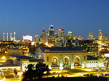 Downtown Kansas City, Missouri, at twilight
Cities and towns
National protected area
- Harry S Truman National Historic Site
Demographics
Historical populations Census Pop. %± 1830 2,823 — 1840 7,612 169.6% 1850 14,000 83.9% 1860 22,913 63.7% 1870 65,011 183.7% 1880 82,825 27.4% 1890 160,510 93.8% 1900 195,193 21.6% 1910 283,522 45.3% 1920 367,846 29.7% 1930 470,454 27.9% 1940 477,828 1.6% 1950 541,035 13.2% 1960 622,732 15.1% 1970 654,558 5.1% 1980 629,266 −3.9% 1990 633,232 0.6% 2000 654,880 3.4% 2010 674,158 2.9% U.S. Decennial Census As of the census[14] of 2000, there were 654,880 people, 266,294 households, and 166,167 families residing in the county. The population density was 1,083 people per square mile (418/km²). There were 288,231 housing units at an average density of 476 per square mile (184/km²). The racial makeup of the county was 70.10% White, 23.27% Black or African American, 0.48% Native American, 1.28% Asian, 0.18% Pacific Islander, 2.43% from other races, and 2.25% from two or more races. 5.37% of the population were Hispanic or Latino of any race. 16.7% were of German, 9.1% American, 8.9% Irish and 8.8% English ancestry according to Census 2000.
There were 266,294 households out of which 29.90% had children under the age of 18 living with them, 43.40% were married couples living together, 14.70% had a female householder with no husband present, and 37.60% were non-families. 31.20% of all households were made up of individuals and 9.90% had someone living alone who was 65 years of age or older. The average household size was 2.42 and the average family size was 3.05.
In the county the population was spread out with 25.80% under the age of 18, 9.10% from 18 to 24, 31.10% from 25 to 44, 21.50% from 45 to 64, and 12.50% who were 65 years of age or older. The median age was 35 years. For every 100 females there were 92.90 males. For every 100 females age 18 and over, there were 89.00 males.
The median income for a household in the county was $39,277, and the median income for a family was $48,435. Males had a median income of $35,798 versus $27,403 for females. The per capita income for the county was $20,788. About 9.00% of families and 11.90% of the population were below the poverty line, including 16.40% of those under age 18 and 8.70% of those age 65 or over.
See also
- List of counties in Missouri
- Missouri census statistical areas
- National Register of Historic Places listings in Jackson County, Missouri
Notes
- ^ "2010 Census 2010". U.S. Census Bureau. http://2010.census.gov/2010census/data/. Retrieved 2011-03-03.
- ^ "Find a County". National Association of Counties. http://www.naco.org/Counties/Pages/FindACounty.aspx. Retrieved 2011-06-07.
- ^ Joseph Fielding Smith, Bruce R. McConkie (ed.) Doctrines of Salvation, Salt Lake City: Bookcraft, 3:74 (1954-56).
- ^ Doctrine & Covenants 57:1-5
- ^ H. Michael Marquardt, "The Independence Temple of Zion", 1997. Retrieved March 28, 2008.
- ^ [1]
- ^ Bruce A. Van Orden, “I Have a Question: What do we know about the location of the Garden of Eden?”, Ensign, Jan. 1994, 54–55; see also Andrew Jenson, Historical Record, 7:438-39 (1888); Orson F. Whitney, Life of Heber C. Kimball, Salt Lake City: Bookcraft, 219 (1967); Heber C. Kimball, "Advancement of the Saints", Journal of Discourses 10:235 (1863); Journal History of the Church of Jesus Christ of Latter-day Saints, Brigham Young to Orson Hyde, March 15, 1857 (1830- ); Wilford Woodruff, Susan Staker (ed.), Waiting for the World to End: The Diaries of Wilford Woodruff, Salt Lake City: Signature Books, 305 (1993); John A. Widtsoe, G. Homer Durham (ed.), Evidences and Reconciliations, 396-397 (1960); Bruce R. McConkie, Mormon Doctrine, Salt Lake City: Bookcraft, 19-20
- ^ [2]
- ^ [3]
- ^ [4]
- ^ Information for this section was obtained largely from 175 Years of Jackson County History, by the Jackson County Historical Society.
- ^ Registered Voters in Missouri 2008
- ^ "Census 2000 U.S. Gazetteer Files: Counties". United States Census. http://www.census.gov/tiger/tms/gazetteer/county2k.txt. Retrieved 2011-02-13.
- ^ "American FactFinder". United States Census Bureau. http://factfinder.census.gov. Retrieved 2008-01-31.
External links
- Jackson County government's website
- Jackson County Historical Society's website
- Digitized 1930 Plat Book of Jackson County from University of Missouri Division of Special Collections, Archives, and Rare Books

Wyandotte County, Kansas Clay County Ray County 
Lafayette County  Jackson County, Missouri

Johnson County, Kansas Cass County Johnson County Kansas City Metropolitan Area's cities and counties Central city 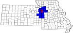
Largest cities (over 100,000 in 2000) Medium-sized cities (10,000 to 100,000 in 2000) Blue Springs • Belton • Excelsior Springs • Gladstone • Grandview • Lansing • Leawood • Leavenworth • Lee's Summit • Lenexa • Liberty • Merriam • Ottawa • Prairie Village • Raymore • Raytown • ShawneeCounties Municipalities and communities of Jackson County, Missouri Cities Blue Springs | Buckner | Grain Valley | Grandview | Greenwood | Independence‡ | Kansas City‡ | Lake Lotawana | Lake Tapawingo | Lee's Summit‡ | Levasy | Lone Jack | Oak Grove‡ | Raytown | Sugar Creek‡

Villages Unincorporated
communityFootnotes ‡This populated place also has portions in an adjacent county or counties
Categories:- Missouri counties
- Kansas City metropolitan area
- Jackson County, Missouri
- Significant places in Mormonism
- Missouri counties on the Missouri River


Wikimedia Foundation. 2010.