- Merriam, Kansas
-
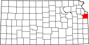
City of Merriam — City — Location of Merriam within Johnson County and the State of Kansas.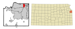
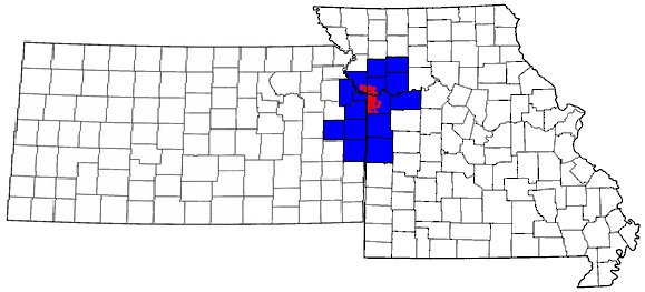
Coordinates: 39°1′15″N 94°41′38″W / 39.02083°N 94.69389°WCoordinates: 39°1′15″N 94°41′38″W / 39.02083°N 94.69389°W Country United States State Kansas County Johnson Incorporated October 28, 1950 Government – Mayor Ken Sissom Area – Total 4.3 sq mi (11.2 km2) – Land 4.3 sq mi (11.2 km2) – Water 0.0 sq mi (0.0 km2) Elevation 909 ft (277 m) Population (2010)[1] – Total 11,003 – Density 2,558.8/sq mi (988/km2) Time zone CST (UTC-6) – Summer (DST) CDT (UTC-5) ZIP codes 66202-66204 Area code(s) 913 FIPS code 20-46000[2] GNIS feature ID 0479213[3] Website www.Merriam.org Merriam (pronounced /ˈmɛriəm/) is a city in the northeastern part of Johnson County, located in northeast Kansas, in the Central United States. As of the 2010 census, the city population was 11,003.[1] As a suburb of Kansas City, Missouri, it is included in the Kansas City Metropolitan Area. It is bordered by the cities of Overland Park to the east and south, Shawnee to the west, and Kansas City, Kansas to the north (in Wyandotte County); the city of Lenexa is less than a mile to the southwest. Merriam is included in the Shawnee Mission postal designation.
Contents
History
Merriam was incorporated as a third class city on October 28, 1950, and established second class city status on January 18, 1957.[4]
The city was named in honor of Charles Merriam, a one-time secretary/treasurer of the then Kansas City, Fort Scott and Gulf railroad which ran through the area. [5] [6]
Geography
Merriam is located at 39°1′15″N 94°41′38″W / 39.02083°N 94.69389°W (39.020888, -94.693784).[7] The city straddles approximately three miles of Interstate 35 from less than a mile southwest of its junction with Interstate 635 south to 75th Street. Shawnee Mission Parkway, an east-west road, nearly bisects the city. U.S. Routes 59 and 69 follow the Interstate to the south of the city and follow Shawnee Mission Parkway to the east from its junction with the Interstate. Turkey Creek, following a roughly parallel path to the Interstate, flows through the city.
According to the United States Census Bureau, the city has a total area of 4.3 square miles (11 km2), all of it land.[2]
Demographics
Historical populations Census Pop. %± 1990 11,821 — 2000 11,008 −6.9% 2010 11,003 0% U.S. Decennial Census As of the U.S. Census in 2000,[2] there were 11,008 people, 4,839 households, and 2,903 families residing in the city. The population density was 2,550.9 people per square mile (983.8/km²). There were 5,042 housing units at an average density of 1,168.4 per square mile (450.6/km²). The racial makeup of the city was 89.24% White, 4.02% Black or African American, 0.42% Native American, 2.09% Asian, 0.02% Pacific Islander, 1.95% from other races, and 2.25% from two or more races. Hispanic or Latino of any race were 5.41% of the population. The ancestral makeup was 21.9% German, 12.9% English, 11.5% Irish and 7.7% American.
There were 4,839 households out of which 26.3% had children under the age of 18 living with them, 46.8% were married couples living together, 9.7% had a female householder with no husband present, and 40.0% were non-families. 33.3% of all households were made up of individuals and 7.6% had someone living alone who was 65 years of age or older. The average household size was 2.23 and the average family size was 2.86.
In the city the population was spread out with 21.7% under the age of 18, 8.3% from 18 to 24, 34.0% from 25 to 44, 23.8% from 45 to 64, and 12.2% who were 65 years of age or older. The median age was 36 years. For every 100 females there were 92.6 males. For every 100 females age 18 and over, there were 90.9 males.
The median income for a household in the city was $48,455, and the median income for a family was $54,639. Males had a median income of $37,358 versus $29,815 for females. The per capita income for the city was $23,988. About 4.3% of families and 6.2% of the population were below the poverty line, including 9.7% of those under age 18 and 7.1% of those age 65 or over.
Economy
Seaboard Corporation is based in Merriam.
Top employers
According to Merriam's 2010 Comprehensive Annual Financial Report,[8] the top employers in the city were:
# Employer # of Employees 1 Shawnee Mission Medical Center 2,700 2 GE Money 530 3 First Student 330 4 Superior Chevrolet/Toyota 281 5 Seaboard Corporation 190 6 Shawnee Mission School District 181 7 CarMax 149 8 The Home Depot 143 9 IBT 142 10 Aristocrat Motors 140 Libraries
Johnson County Library serves residents of Merriam. The library's Antioch branch is located at the intersection of Shawnee Mission Parkway and Antioch road. At one time, this branch served as the headquarters for the library system.
Notable people
Scott P. Roeder, suspected domestic terrorist and alleged killer of George Tiller
References
- ^ a b "2010 City Population and Housing Occupancy Status". U.S. Census Bureau. http://factfinder2.census.gov/faces/tableservices/jsf/pages/productview.xhtml?pid=DEC_10_PL_GCTPL2.ST13&prodType=table. Retrieved March 6, 2011.
- ^ a b c "American FactFinder". United States Census Bureau. http://factfinder.census.gov. Retrieved 2008-01-31.
- ^ "US Board on Geographic Names". United States Geological Survey. 2007-10-25. http://geonames.usgs.gov. Retrieved 2008-01-31.
- ^ "Our City". City of Merriam. http://www.merriam.org/city/index.htm. Retrieved 2006-07-23.
- ^ http://www.kshs.org/kansapedia/johnson-county-kansas/15301
- ^ http://www.exploremerriam.com/MERRIAM/index.htm#History
- ^ "US Gazetteer files: 2010, 2000, and 1990". United States Census Bureau. 2011-02-12. http://www.census.gov/geo/www/gazetteer/gazette.html. Retrieved 2011-04-23.
- ^ City of Merriam CAFR
External links
- Official sites
- History
Municipalities and communities of Johnson County, Kansas Cities Bonner Springs‡ | De Soto‡ | Edgerton | Fairway | Gardner | Lake Quivira‡ | Leawood | Lenexa | Merriam | Mission | Mission Hills | Mission Woods | Olathe | Overland Park | Prairie Village | Roeland Park | Shawnee | Spring Hill‡ | Westwood | Westwood Hills
Townships Aubry | Gardner | Lexington | McCamish | Olathe | Oxford | Shawnee | Spring Hill
Unincorporated
communityFootnotes ‡This populated place also has portions in an adjacent county or counties
Kansas City Metropolitan Area's cities and counties Central city 
Largest cities (over 100,000 in 2000) Medium-sized cities (10,000 to 100,000 in 2000) Blue Springs • Belton • Excelsior Springs • Gladstone • Grandview • Lansing • Leawood • Leavenworth • Lee's Summit • Lenexa • Liberty • Merriam • Ottawa • Prairie Village • Raymore • Raytown • ShawneeCounties Categories:- Cities in Kansas
- Populated places in Johnson County, Kansas
- Kansas City metropolitan area


Wikimedia Foundation. 2010.