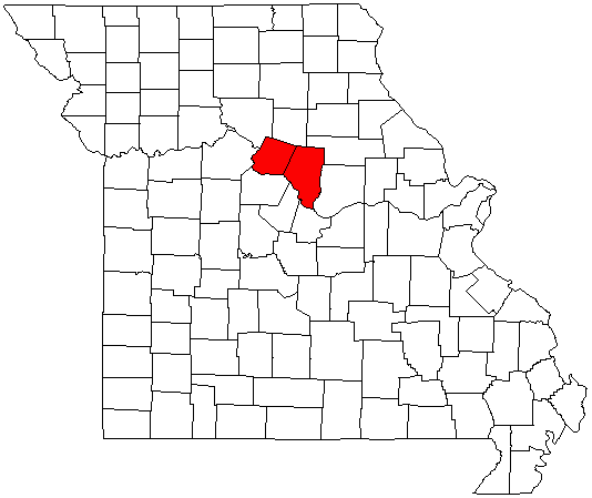
- Columbia, Missouri Metropolitan Area
-
Columbia 
Common name: Columbia Metropolitan AreaLargest city Columbia Other cities - Ashland
- Fayette
- Centralia
- RocheportPopulation Ranked 235th in the U.S. - Total 173083 Area sq. mi.
km²State(s) - Missouri Elevation - Highest point N/A feet (N/A m) - Lowest point 0 feet (0 m) The Columbia, Missouri Metropolitan Statistical Area, as defined by the United States Census Bureau, is an area consisting of two counties—Boone and Howard—in central Missouri, anchored by the city of Columbia. As of the 2010 Census, the MSA had an estimated population of 173,083[1]
Contents
Counties
Cities and villages
Boone County
- Ashland
- Centralia (partial)
- Columbia (Principal city)
- Hallsville
- Harrisburg
- Hartsburg
- Huntsdale
- McBaine
- Pierpont
- Rocheport
- Sturgeon
- Two Mile Prairie (unincorporated)
Howard County
- Armstrong
- Fayette
- Franklin
- Glasgow (partial)
- New Franklin
Demographics
As of the census[2] of 2000, there were 145,666 people, 56,930 households, and 34,010 families residing within the MSA. The racial makeup of the MSA was 85.83% White, 8.42% African American, 0.41% Native American, 2.76% Asian, 0.03% Pacific Islander, 0.67% from other races, and 1.87% from two or more races. Hispanic or Latino of any race were 1.72% of the population.
The median income for a household in the MSA was $34,550, and the median income for a family was $45,689. Males had a median income of $29,837 versus $22,970 for females. The per capita income for the MSA was $17,521.
See also
References
The City of Columbia 
History · Government and Politics · Geography · Demographics · Transportation
Metropolitan Area - State of Missouri - Famous Citizens
Culture · Media · Sports · Education- 38°57′06″N 92°19′43″W / 38.951557°N 92.328591°WCoordinates: 38°57′06″N 92°19′43″W / 38.951557°N 92.328591°W Columbia, Missouri Metropolitan Area
Categories:
Wikimedia Foundation. 2010.