- Dearborn County, Indiana
-
Dearborn County, Indiana 
Location in the state of Indiana
Indiana's location in the U.S.Founded 1803 Named for Dr. Henry Dearborn Seat Lawrenceburg Area
- Total
- Land
- Water
307.42 sq mi (796 km²)
305.03 sq mi (790 km²)
2.38 sq mi (6 km²), 0.77%Population
- (2010)
- Density
50,047
164/sq mi (63.31/km²)Congressional districts 6th, 9th Footnotes: Indiana county number 15
Dearborn County is a county located in the U.S. state of Indiana. As of 2010, the population was 50,047.[1] It is part of the Cincinnati-Northern Kentucky metropolitan area. The county seat is Lawrenceburg[2].
Contents
History
Dearborn County was formed in 1803. It was named for Dr. Henry Dearborn (DR), an officer in the Revolutionary War and the War of 1812. Dearborn was U.S. Secretary of War at the time the County was named. Early growth was centered around Lawrenceburg which was an important railroad junction connecting two of the regions major rail lines.[3]
Geography
According to the 2010 census, the county has a total area of 307.42 square miles (796.2 km2), of which 305.03 square miles (790.0 km2) (or 99.22%) is land and 2.38 square miles (6.2 km2) (or 0.77%) is water.[4] Part of the southeastern county line is formed by the Ohio River.
Cities and towns
Townships
- Caesar Creek
- Center
- Clay
- Harrison
- Hogan
- Jackson
- Kelso
- Lawrenceburg
- Logan
- Manchester
- Miller
- Sparta
- Washington
- York
Major highways
 Interstate 74
 Interstate 275
 U.S. Route 50
 U.S. Route 52
 Indiana State Road 1
 Indiana State Road 46
 Indiana State Road 48
 Indiana State Road 56
 Indiana State Road 62
 Indiana State Road 101
 Indiana State Road 350
Adjacent counties
- Franklin County (north)
- Butler County, Ohio (northeast)
- Hamilton County, Ohio (east)
- Boone County, Kentucky (southeast)
- Ohio County (south)
- Ripley County (west)
Climate and weather
Lawrenceburg, Indiana Climate chart (explanation) J F M A M J J A S O N D 3.53821344244.454314.464395.574494.682584.68663485622.979553.267433.855353.74326Average max. and min. temperatures in °F Precipitation totals in inches Source: The Weather Channel[5] Metric conversion J F M A M J J A S O N D 893-6777-411112-11121841402391172814116301710029177526138019697132936-3Average max. and min. temperatures in °C Precipitation totals in mm In recent years, average temperatures in Lawrenceburg have ranged from a low of 21 °F (−6 °C) in January to a high of 86 °F (30 °C) in July, although a record low of −25 °F (−32 °C) was recorded in January 1977 and a record high of 107 °F (42 °C) was recorded in July 1988. Average monthly precipitation ranged from 2.94 inches (75 mm) in September to 5.53 inches (140 mm) in May.[5]
Government
See also: Government of IndianaThe county government is a constitutional body, and is granted specific powers by the Constitution of Indiana, and by the Indiana Code.
County Council: The county council is the legislative branch of the county government and controls all the spending and revenue collection in the county. Representatives are elected from county districts. The council members serve four year terms. They are responsible for setting salaries, the annual budget, and special spending. The council also has limited authority to impose local taxes, in the form of an income and property tax that is subject to state level approval, excise taxes, and service taxes.[6][7]
Board of Commissioners: The executive body of the county is made of a board of commissioners. The commissioners are elected county-wide, in staggered terms, and each serves a four-year term. One of the commissioners, typically the most senior, serves as president. The commissioners are charged with executing the acts legislated by the council, collecting revenue, and managing the day-to-day functions of the county government.[6][7]
Court: Dearborn County's courts consist of a Circuit Court and two Superior Courts. Judges are elected to six year terms. Lawrenceburg and Aurora also have City Courts. Judges there serve four year terms.
County Officials: The county has several other elected offices, including sheriff, prosecuting attorney, coroner, auditor, treasurer, recorder, surveyor, and circuit court clerk. Each of these elected officers serves a term of four years and oversees a different part of county government. Members elected to county government positions are required to declare a party affiliation and to be residents of the county.[7]
Dearborn County is part of Indiana's 6th congressional district and Indiana's 9th congressional district; Indiana Senate district 43;[8] and Indiana House of Representatives districts 55 and 68.[9]
Demographics
Historical populations Census Pop. %± 1810 7,310 — 1820 11,468 56.9% 1830 13,974 21.9% 1840 19,327 38.3% 1850 20,166 4.3% 1860 24,406 21.0% 1870 24,116 −1.2% 1880 26,671 10.6% 1890 23,364 −12.4% 1900 22,194 −5.0% 1910 21,396 −3.6% 1920 20,033 −6.4% 1930 21,056 5.1% 1940 23,053 9.5% 1950 25,141 9.1% 1960 28,674 14.1% 1970 29,430 2.6% 1980 34,291 16.5% 1990 38,835 13.3% 2000 46,109 18.7% 2010 50,047 8.5% Sources: United States Department of Commerce,
Bureau of the Census, Population Division[10]
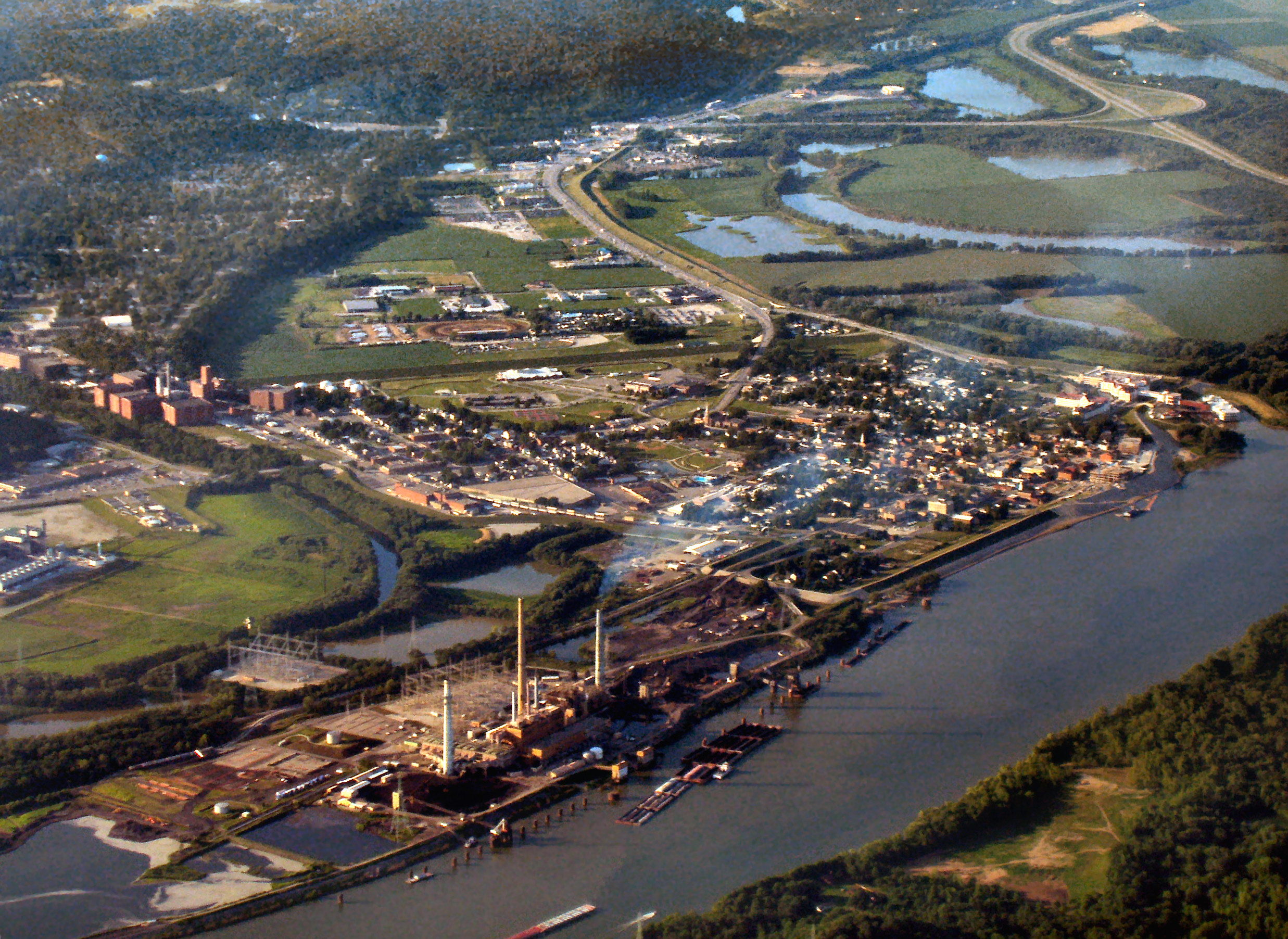
Census Quickfacts[1] Lawrenceburg on the Ohio River, from the air. AEP's Tanner's Creek Generating Station at lower-left.
As of the census[11] of 2000, there were 46,109 people, 16,832 households, and 12,775 families residing in the county. The population density was 151 people per square mile (58/km²). There were 17,791 housing units at an average density of 58 per square mile (23/km²). The racial makeup of the county was 98.06% White, 0.62% Black or African American, 0.16% Native American, 0.26% Asian, 0.03% Pacific Islander, 0.18% from other races, and 0.68% from two or more races. 0.58% of the population were Hispanic or Latino of any race. 41.3% were of German, 18.5% American, 9.8% Irish and 8.8% English ancestry according to Census 2000.
There were 16,832 households out of which 37.40% had children under the age of 18 living with them, 62.50% were married couples living together, 9.60% had a female householder with no husband present, and 24.10% were non-families. 20.10% of all households were made up of individuals and 8.10% had someone living alone who was 65 years of age or older. The average household size was 2.71 and the average family size was 3.13.
In the county the population was spread out with 27.60% under the age of 18, 7.70% from 18 to 24, 30.20% from 25 to 44, 23.30% from 45 to 64, and 11.20% who were 65 years of age or older. The median age was 36 years. For every 100 females there were 98.10 males. For every 100 females age 18 and over, there were 96.00 males.
The median income for a household in the county was $48,899, and the median income for a family was $54,806. Males had a median income of $38,687 versus $26,148 for females. The per capita income for the county was $20,431. About 4.80% of families and 6.60% of the population were below the poverty line, including 8.20% of those under age 18 and 7.20% of those age 65 or over.
See also
References
- ^ a b "Dearborn County QuickFacts". United States Census Bureau. http://quickfacts.census.gov/qfd/states/18/18029.html. Retrieved 2011-09-17.
- ^ "Find a County". National Association of Counties. http://www.naco.org/Counties/Pages/FindACounty.aspx. Retrieved 2011-06-07.
- ^ De Witt Clinton Goodrich & Charles Richard Tuttle (1875). An Illustrated History of the State of Indiana. Indiana: R. S. Peale & co.. pp. 553. http://books.google.com/books?id=YDIUAAAAYAAJ.
- ^ "Census 2010 U.S. Gazetteer Files: Counties". United States Census. http://www.census.gov/geo/www/gazetteer/files/Gaz_counties_national.txt. Retrieved 2011-10-10.
- ^ a b "Monthly Averages for Lawrenceburg, Indiana". The Weather Channel. http://www.weather.com/weather/wxclimatology/monthly/graph/USIN0355. Retrieved 2011-01-27.
- ^ a b Indiana Code. "Title 36, Article 2, Section 3". IN.gov. http://www.in.gov/legislative/ic/code/title36/ar2/ch3.html. Retrieved 2008-09-16.
- ^ a b c Indiana Code. "Title 2, Article 10, Section 2". IN.gov. http://www.in.gov/legislative/ic/code/title3/ar10/ch2.pdf. Retrieved 2008-09-16.
- ^ "Indiana Senate Districts". State of Indiana. http://www.in.gov/sos/elections/3006.htm. Retrieved 2011-01-23.
- ^ "Indiana House Districts". State of Indiana. http://www.in.gov/sos/elections/3005.htm. Retrieved 2011-01-23.
- ^ Forstall, Richard L. (editor) (1996). Population of states and counties of the United States: 1790 to 1990 : from the twenty-one decennial censuses. United States Department of Commerce, Bureau of the Census, Population Division. pp. 50–53. ISBN 0-934213-48-8. http://books.google.com/books?id=Z12v1lrkv2IC&lpg=PA50&pg=PA50#v=onepage&q&f=false.
- ^ "American FactFinder". United States Census Bureau. http://factfinder.census.gov. Retrieved 2008-01-31.
External links

Franklin County Butler County, Ohio Ripley County 
Hamilton County, Ohio  Dearborn County, Indiana

Ohio County Boone County, Kentucky Municipalities and communities of Dearborn County, Indiana Cities 
Towns Townships Caesar Creek | Center | Clay | Harrison | Hogan | Jackson | Kelso | Lawrenceburg | Logan | Manchester | Miller | Sparta | Washington | York
Unincorporated
communitiesBonnell | Braysville | Bright | Chesterville | Cold Springs | Dover | Farmers Retreat | Guilford | Hardinsburg | Hidden Valley | Hubbells Corner | Kyle | Lawrenceburg Junction | Lawrenceville | Logan | Manchester | Mount Sinai | New Alsace | Sparta | Weisburg | Wilmington | Wrights Corner | Yorkville
Categories:- Indiana counties
- Dearborn County, Indiana
- 1803 establishments in the United States
- Populated places established in 1803
- Ohio River counties


Wikimedia Foundation. 2010.