- National Register of Historic Places listings in Dearborn County, Indiana
-
 Location of Dearborn County in Indiana
This is a list of the National Register of Historic Places listings in Dearborn County, Indiana.
This is intended to be a complete list of the properties and districts on the National Register of Historic Places in Dearborn County, Indiana, United States. Latitude and longitude coordinates are provided for many National Register properties and districts; these locations may be seen together in a Google map.[1]
There are 25 properties and districts listed on the National Register in the county, including 1 National Historic Landmark.
-
- This National Park Service list is complete through NPS recent listings posted November 10, 2011.[2]
Current listings
[3] Landmark name [4] Image Date listed Location City or town Summary 1 Aurora City Hall March 14, 1996 216 3rd St. and 233-237 Main St.
39°03′19″N 84°54′00″W / 39.055278°N 84.9°WAurora 2 Aurora Methodist Episcopal Church September 8, 1994 304 3rd St.
39°03′20″N 84°54′03″W / 39.055556°N 84.900833°WAurora 3 Aurora Public Library May 27, 1993 414 2nd St.
39°03′25″N 84°54′05″W / 39.056944°N 84.901389°WAurora Renaissance style building designed by Garber & Woodward in 1923 4 Carnegie Hall of Moores Hill College March 17, 1994 14687 Main St.
39°06′43″N 85°05′32″W / 39.111944°N 85.092222°WMoores Hill 5 Dearborn County Asylum for the Poor September 22, 2000 11636 County Farm Rd.
39°09′01″N 85°02′03″W / 39.150278°N 85.034167°WAurora 6 Dearborn County Courthouse April 9, 1981 High and Mary Sts.
39°05′28″N 84°50′59″W / 39.091111°N 84.849722°WLawrenceburg 7 Downtown Aurora Historic District September 8, 1994 Bounded by Importing, Water, Market, 5th, and Exporting Sts.
39°03′14″N 84°54′02″W / 39.053889°N 84.900556°WAurora 8 Downtown Lawrenceburg Historic District March 1, 1984 Roughly bounded by the former Conrail railroad line and Charlotte, Tate, Williams, and Elm Sts.
39°05′37″N 84°50′54″W / 39.093611°N 84.848333°WLawrenceburg 9 First Evangelical United Church of Christ September 23, 1994 111 5th St.
39°03′11″N 84°53′56″W / 39.053056°N 84.898889°WAurora 10 First Presbyterian Church September 8, 1994 215 4th St.
39°03′15″N 84°53′52″W / 39.054167°N 84.897778°WAurora 11 George Street Bridge March 1, 1984 George, Main, and Importing Sts.
39°03′29″N 84°53′58″W / 39.058056°N 84.899444°WAurora 12 Hamline Chapel, United Methodist Church September 9, 1982 High and Vine Sts.
39°05′29″N 84°50′51″W / 39.091389°N 84.8475°WLawrenceburg 13 Hillforest (Forest Hill) 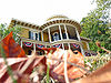
August 5, 1971 213 5th St.
39°03′14″N 84°54′06″W / 39.053889°N 84.901667°WAurora 14 Lewis Hurlbert, Sr. House November 25, 1994 412 5th St.
39°03′17″N 84°54′13″W / 39.054722°N 84.903611°WAurora 15 Jennison Guard Site May 12, 1975 Between a rail line and the Ohio River, just west of the mouth of the Great Miami River
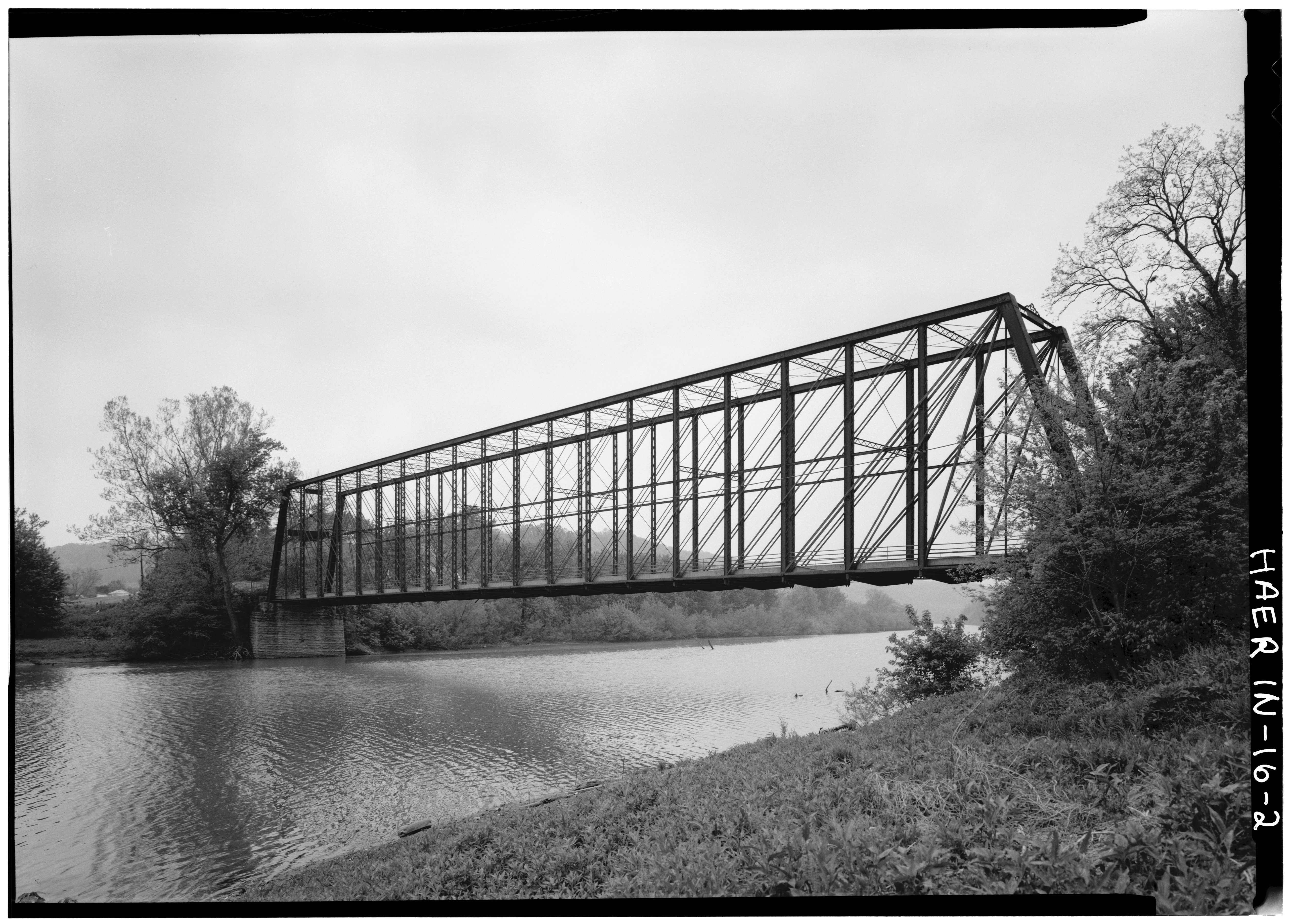
39°6′32″N 84°49′30″W / 39.10889°N 84.825°W[5]Lawrenceburg 16 Laughery Creek Bridge 
September 29, 1976 South of Aurora west of State Road 56
39°01′28″N 84°53′09″W / 39.024444°N 84.885833°WAurora Extends into Ohio County 17 Leive, Parks and Stapp Opera House September 20, 1994 321-325 2nd St.
39°03′23″N 84°54′04″W / 39.056389°N 84.901111°WAurora 18 Daniel S. Major House December 23, 2003 761 W. Eads Parkway
39°05′21″N 84°52′35″W / 39.089167°N 84.876389°WLawrenceburg 19 Moore's Hill United Methodist Church December 15, 1997 13476 Main St.
39°06′47″N 85°05′16″W / 39.113056°N 85.087778°WMoores Hill 20 St. John's Lutheran Church and School March 29, 1996 7291 State Road 62
38°58′36″N 85°06′18″W / 38.976667°N 85.105°WDillsboro 21 Levi Stevens House May 30, 1996 122 5th St.
39°03′13″N 84°53′59″W / 39.053611°N 84.899722°WAurora 22 State Line Archeological District 
July 24, 1975 Straddling the Ohio/Indiana border, 2 miles (3.2 km) north of the Ohio River
39°8′15″N 84°49′12″W / 39.1375°N 84.82°W[6]Lawrenceburg Township Extends into Hamilton County, Ohio 23 Dr. George Sutton Medical Office Building September 8, 1994 315 3rd St.
39°03′19″N 84°54′06″W / 39.055278°N 84.901667°WAurora 24 Vance-Tousey House December 28, 2000 508 W. High St.
39°05′26″N 84°51′14″W / 39.090556°N 84.853889°WLawrenceburg 25 Veraestau 
April 11, 1973 1 mile south of Aurora on State Road 56
39°02′29″N 84°53′53″W / 39.041389°N 84.898056°WAurora See also
- List of National Historic Landmarks in Indiana
- National Register of Historic Places listings in Indiana
References
- ^ The latitude and longitude information provided in this table was derived originally from the National Register Information System, which has been found to be fairly accurate for about 99% of listings. For about 1% of NRIS original coordinates, experience has shown that one or both coordinates are typos or otherwise extremely far off; some corrections may have been made. A more subtle problem causes many locations to be off by up to 150 yards, depending on location in the country: most NRIS coordinates were derived from tracing out latitude and longitudes off of USGS topographical quadrant maps created under North American Datum of 1927, which differs from the current, highly accurate GPS system used by Google maps. Chicago is about right, but NRIS longitudes in Washington are higher by about 4.5 seconds, and are lower by about 2.0 seconds in Maine. Latitudes differ by about 1.0 second in Florida. Some locations in this table may have been corrected to current GPS standards.
- ^ "National Register of Historic Places: Weekly List Actions". National Park Service, United States Department of the Interior. Retrieved on November 10, 2011.
- ^ Numbers represent an ordering by significant words. Various colorings, defined here, differentiate National Historic Landmark sites and National Register of Historic Places Districts from other NRHP buildings, structures, sites or objects.
- ^ "National Register Information System". National Register of Historic Places. National Park Service. . http://nrhp.focus.nps.gov/natreg/docs/All_Data.html.
- ^ Location derived from Kozarek, Sue Ellen. "Determining Sedentism in the Archaeological Record". Ohio Hopewell Community Organization. Ed. William S. Dancey and Paul J. Pacheco. Kent: Kent State UP, 1997. 131-152: 141. The NRIS lists the site as "Address Restricted".
- ^ Location derived from Gosman, James Howard. Patterns in Ontogeny of Human Trabecular Bone from Sunwatch Village in the Prehistoric Ohio Valley. Diss. Ohio State University, 2007. Accessed 2010-04-14. The NRIS lists the site as "Address Restricted".
U.S. National Register of Historic Places Topics Lists by states Alabama • Alaska • Arizona • Arkansas • California • Colorado • Connecticut • Delaware • Florida • Georgia • Hawaii • Idaho • Illinois • Indiana • Iowa • Kansas • Kentucky • Louisiana • Maine • Maryland • Massachusetts • Michigan • Minnesota • Mississippi • Missouri • Montana • Nebraska • Nevada • New Hampshire • New Jersey • New Mexico • New York • North Carolina • North Dakota • Ohio • Oklahoma • Oregon • Pennsylvania • Rhode Island • South Carolina • South Dakota • Tennessee • Texas • Utah • Vermont • Virginia • Washington • West Virginia • Wisconsin • WyomingLists by territories Lists by associated states Other Municipalities and communities of Dearborn County, Indiana Cities 
Towns Townships Caesar Creek | Center | Clay | Harrison | Hogan | Jackson | Kelso | Lawrenceburg | Logan | Manchester | Miller | Sparta | Washington | York
Unincorporated
communitiesBonnell | Braysville | Bright | Chesterville | Cold Springs | Dover | Farmers Retreat | Guilford | Hardinsburg | Hidden Valley | Hubbells Corner | Kyle | Lawrenceburg Junction | Lawrenceville | Logan | Manchester | Mount Sinai | New Alsace | Sparta | Weisburg | Wilmington | Wrights Corner | Yorkville
Categories:- National Register of Historic Places in Dearborn County, Indiana
- National Register of Historic Places in Indiana by county
-


Wikimedia Foundation. 2010.