- National Register of Historic Places listings in Canyon County, Idaho
-
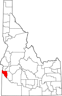 Location of Canyon County in Idaho
This is a list of the National Register of Historic Places listings in Canyon County, Idaho.
This is intended to be a complete list of the properties and districts on the National Register of Historic Places in Canyon County, Idaho, United States. Latitude and longitude coordinates are provided for many National Register properties and districts; these locations may be seen together in a Google map.[1]
There are 44 properties and districts listed on the National Register in the county. More may be added; properties and districts nationwide are added to the Register weekly.[2]
-
- This National Park Service list is complete through NPS recent listings posted November 10, 2011.[3]
Current listings
[4] Landmark name [5] Image Date listed Location City or town Summary 1 F.F. Beale House May 14, 1993 1802 Cleveland Boulevard
43°39′25″N 116°40′42″W / 43.656944°N 116.678333°WCaldwell 2 Blatchley Hall March 8, 1978 College of Idaho campus
43°39′09″N 116°40′27″W / 43.6525°N 116.674167°WCaldwell 3 Boise River and Canal Bridge February 7, 2007 Plymouth St.
43°41′20″N 116°41′10″W / 43.688889°N 116.686111°WCaldwell 4 Caldwell Carnegie Library June 18, 1979 1101 Cleveland Boulevard
43°39′44″N 116°41′07″W / 43.662222°N 116.685278°WCaldwell 5 Caldwell Historic District July 19, 1982 Roughly bounded by Railroad and Arthur Sts. and 7th and 9th Aves.
43°40′00″N 116°41′13″W / 43.666667°N 116.686944°WCaldwell 6 Caldwell Odd Fellow Home for the Aged November 17, 1982 N. 14th Ave.
43°40′00″N 116°40′20″W / 43.666667°N 116.672222°WCaldwell 7 Caldwell Residential Historic District September 23, 2002 Roughly bounded by Cleveland Boulevard, Everett St., S. 12th Ave., and S. 20th Ave.
43°39′27″N 116°40′53″W / 43.6575°N 116.681389°WCaldwell 8 E.H. Dewey Stores November 17, 1982 1013-15 1st. St., S.
43°34′48″N 116°33′38″W / 43.58°N 116.560556°WNampa 9 Diversion Dam and Deer Flat Embankments 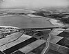
March 15, 1976 Southeast of Boise on the Boise River
43°34′26″N 116°42′23″W / 43.573889°N 116.706389°WBoise Extends into Ada County 10 Henry W. and Ida Frost Dorman House July 5, 2000 114 Logan St.
43°39′18″N 116°41′46″W / 43.655°N 116.696111°WCaldwell 11 Farmers and Merchants Bank May 13, 1976 101 11th Ave., S.
43°34′47″N 116°33′37″W / 43.579722°N 116.560278°WNampa 12 Fort Boise and Riverside Ferry Sites December 24, 1974 Northwest of Parma on the Snake River
43°49′37″N 117°01′02″W / 43.826944°N 117.017222°WParma 13 Guffey Butte-Black Butte Archeological District October 10, 1978 Approximately 20 miles (32 km) along the Snake River
43°17′10″N 116°32′28″W / 43.28611°N 116.54111°W[6]Grand View Extends into Ada, Elmore, and Owyhee counties 14 Horse Barn October 11, 1978 Northeast of Nampa at Idaho State School and Hospital
43°36′12″N 116°31′29″W / 43.603333°N 116.524722°WNampa 15 Ellen Houlder Farm June 23, 1994 Arena Valley Rd. (Route 2) west of Wilder
43°40′54″N 116°59′11″W / 43.681667°N 116.986389°WWilder 16 Idaho State Sanitarium Administration Building November 17, 1982 Northeast of Nampa on 11th Ave., N.
43°36′09″N 116°31′49″W / 43.6025°N 116.530278°WNampa 17 Thomas K. Little House August 18, 1980 703 E. Belmont St.
43°40′08″N 116°41′05″W / 43.668889°N 116.684722°WCaldwell 18 Jacob P. Lockman House July 27, 2005 23 9th Ave. N
43°34′58″N 116°33′38″W / 43.582778°N 116.560556°WNampa 19 Map Rock Petroglyphs Historic District November 15, 1982 Address Restricted[7] Givens Springs 20 Middleton Substation May 7, 1973 State Highway 44
43°42′23″N 116°36′59″W / 43.706389°N 116.616389°WMiddleton 21 Nampa American Legion Chateau November 17, 1982 1508 2nd St., S.
43°34′34″N 116°33′22″W / 43.576111°N 116.556111°WNampa 22 Nampa and Meridian Irrigation District Office November 17, 1982 1503 1st St., S.
43°34′35″N 116°33′20″W / 43.576389°N 116.555556°WNampa 23 Nampa City Hall May 9, 1985 203 12th Ave., S.
43°34′41″N 116°33′37″W / 43.578056°N 116.560278°WNampa 24 Nampa Department Store November 17, 1982 1st St., S. and 13th Ave.
43°35′13″N 116°33′27″W / 43.586944°N 116.5575°WNampa 25 Nampa Depot November 3, 1972 12th Ave. and Front St.
43°34′46″N 116°33′32″W / 43.5795°N 116.55887°WNampa 26 Nampa First Methodist Episcopal Church November 17, 1982 12th Ave., S. and 4th St.
43°34′34″N 116°33′42″W / 43.576111°N 116.561667°WNampa 27 Nampa Historic District August 18, 1983 1200 and 1300 blocks S. 1st St.
43°34′41″N 116°33′28″W / 43.578056°N 116.557778°WNampa 28 Nampa Presbyterian Church November 17, 1982 2nd St. and 15th Ave., S.
43°34′34″N 116°33′25″W / 43.576111°N 116.556944°WNampa 29 North Caldwell Historic District September 5, 1979 9th, Albany, and Belmont Sts.
43°40′02″N 116°41′00″W / 43.667222°N 116.683333°WCaldwell 30 George Obendorf Gothic Arch Truss Barn October 28, 1999 24047 Batt Corner Rd.
43°43′14″N 116°55′19″W / 43.720556°N 116.921944°WWilder 31 Old Nampa Neighborhood Historic District March 21, 2007 Roughly bounded by 4th Ave., S, 4th St., S, 11th Ave., S, and 9th St., S.
43°34′41″N 116°34′10″W / 43.57812°N 116.5694°WNampa 32 Peckham Barn October 7, 1982 North of Wilder on U.S. Route 95
43°41′02″N 116°54′33″W / 43.683889°N 116.909167°WWilder 33 John C. Rice House May 27, 1980 1520 Cleveland Boulevard
43°39′31″N 116°40′52″W / 43.658611°N 116.681111°WCaldwell 34 Roswell Grade School November 17, 1982 State Highway 18 and Stephan Lane
43°44′56″N 116°57′37″W / 43.748889°N 116.960278°WRoswell 35 Sacred Hearts of Jesus and Mary Church November 17, 1982 608 7th St.
43°47′16″N 116°56′14″W / 43.787778°N 116.937222°WParma 36 St. Mary's Catholic Church November 17, 1982 616 Dearborn
43°39′52″N 116°41′29″W / 43.664444°N 116.691389°WCaldwell 37 St. Paul's Rectory and Sisters' House November 17, 1982 810 15th Ave., S.
43°34′15″N 116°33′45″W / 43.570833°N 116.5625°WNampa 38 Sterry Hall March 8, 1978 College of Idaho campus
43°39′14″N 116°40′33″W / 43.653889°N 116.675833°WCaldwell 39 A.K. Steunenberg House November 17, 1982 409 N. Kimball
43°40′09″N 116°40′59″W / 43.669167°N 116.683056°WCaldwell 40 A.H. Stewart House October 25, 1979 3rd St. and Bates Ave
43°47′11″N 116°56′34″W / 43.786389°N 116.942778°WParma 41 Carrie Adell Strahorn Memorial Library April 15, 1982 College of Idaho
43°39′11″N 116°40′34″W / 43.653056°N 116.676111°WCaldwell 42 US Post Office-Caldwell Main March 16, 1989 823 Arthur St.
43°39′55″N 116°41′09″W / 43.665278°N 116.685833°WCaldwell 43 US Post Office-Nampa Main March 16, 1989 123 11th Ave., S.
43°34′46″N 116°35′08″W / 43.579444°N 116.585556°WNampa 44 Orton H. Wiley House September 11, 1986 524 E. Dewey
43°33′50″N 116°33′54″W / 43.563889°N 116.565°WNampa See also
References
- ^ The latitude and longitude information provided in this table was derived originally from the National Register Information System, which has been found to be fairly accurate for about 99% of listings. For about 1% of NRIS original coordinates, experience has shown that one or both coordinates are typos or otherwise extremely far off; some corrections may have been made. A more subtle problem causes many locations to be off by up to 150 yards, depending on location in the country: most NRIS coordinates were derived from tracing out latitude and longitudes off of USGS topographical quadrant maps created under the North American Datum of 1927, which differs from the current, highly accurate WGS84 GPS system used by Google maps. Chicago is about right, but NRIS longitudes in Washington are higher by about 4.5 seconds, and are lower by about 2.0 seconds in Maine. Latitudes differ by about 1.0 second in Florida. Some locations in this table may have been corrected to current GPS standards.
- ^ "National Register of Historic Places: Weekly List Actions". National Park Service. http://www.cr.nps.gov/nr/nrlist.htm. Retrieved March 29, 2009.
- ^ "National Register of Historic Places: Weekly List Actions". National Park Service, United States Department of the Interior. Retrieved on November 10, 2011.
- ^ Numbers represent an ordering by significant words. Various colorings, defined here, differentiate National Historic Landmark sites and National Register of Historic Places Districts from other NRHP buildings, structures, sites or objects.
- ^ "National Register Information System". National Register of Historic Places. National Park Service. . http://nrhp.focus.nps.gov/natreg/docs/All_Data.html.
- ^ Location derived from this Bureau of Land Management website; coordinates derived from the GNIS feature record for Guffey Butte. The NRIS lists the site as "Address Restricted".
- ^ Some listings on the NRHP are highly sensitive sites and may be subject to looting or vandalism. The NRHP lists this site as "Address Restricted."
Properties on the National Register of Historic Places in Idaho  Ada • Adams • Bannock • Bear Lake • Benewah • Bingham • Blaine • Boise • Bonner • Bonneville • Boundary • Butte • Camas • Canyon • Caribou • Cassia • Clark • Clearwater • Custer • Elmore • Franklin • Fremont • Gem • Gooding • Idaho • Jefferson • Jerome • Kootenai • Latah • Lemhi • Lewis • Lincoln • Madison • Minidoka • Nez Perce • Oneida • Owyhee • Payette • Power • Shoshone • Teton • Twin Falls • Valley • Washington
U.S. National Register of Historic Places Topics Lists by states Alabama • Alaska • Arizona • Arkansas • California • Colorado • Connecticut • Delaware • Florida • Georgia • Hawaii • Idaho • Illinois • Indiana • Iowa • Kansas • Kentucky • Louisiana • Maine • Maryland • Massachusetts • Michigan • Minnesota • Mississippi • Missouri • Montana • Nebraska • Nevada • New Hampshire • New Jersey • New Mexico • New York • North Carolina • North Dakota • Ohio • Oklahoma • Oregon • Pennsylvania • Rhode Island • South Carolina • South Dakota • Tennessee • Texas • Utah • Vermont • Virginia • Washington • West Virginia • Wisconsin • WyomingLists by territories Lists by associated states Other Municipalities and communities of Canyon County, Idaho Cities 
Unincorporated
communitiesBowmont | Huston | Riverside
Categories:- National Register of Historic Places in Idaho by county
- Canyon County, Idaho
-


Wikimedia Foundation. 2010.