- National Register of Historic Places listings in Valley County, Idaho
-
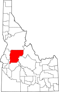 Location of Valley County in Idaho
This is a list of the National Register of Historic Places listings in Valley County, Idaho.
This is intended to be a complete list of the properties and districts on the National Register of Historic Places in Valley County, Idaho, United States. Latitude and longitude coordinates are provided for many National Register properties and districts; these locations may be seen together in a Google map.[1]
There are 24 properties and districts listed on the National Register in the county. More may be added; properties and districts nationwide are added to the Register weekly.[2]
-
- This National Park Service list is complete through NPS recent listings posted November 10, 2011.[3]
Current listings
[4] Landmark name [5] Image Date listed Location City or town Summary 1 Big Creek Commissary April 21, 2000 Yellow Pine in the Payette National Forest
45°08′16″N 115°19′08″W / 45.137778°N 115.318889°WYellow Pine 2 Braddock Gold Mining and Milling Company Log Building and Forge Ruins September 12, 1985 Off Pack Trail near Suicide Rock
44°59′21″N 115°08′09″W / 44.989167°N 115.135833°WThunder City 3 Cabin Creek Ranch June 27, 1990 Cabin Creek at its confluence with Big Creek in the Payette National Forest
45°08′14″N 114°56′01″W / 45.137222°N 114.933611°WBlack Butte 4 Elo School July 26, 1982 Southeast of State Highway 55 on Farm to Market Rd.
44°53′10″N 116°03′34″W / 44.886111°N 116.059444°WMcCall 5 Matt N. Hill Homestead Barn November 17, 1982 Southeast of McCall
44°53′02″N 116°03′26″W / 44.883889°N 116.057222°WMcCall 6 Thomas Jarvi Homestead November 17, 1982 East of Lake Fork on Finn Rd.
44°49′58″N 116°04′49″W / 44.832778°N 116.080278°WLake Fork 7 John G. Johnson (Rintakangas) Homestead November 17, 1982 Northeast of Lake Fork off Pearson Rd.
44°52′01″N 116°02′56″W / 44.866944°N 116.048889°WLake Fork 8 John S. Johnson (Sampila) Homestead November 17, 1982 Northeast of Lake Fork off Pearson Rd.
44°51′40″N 116°03′33″W / 44.861111°N 116.059167°WLake Fork 9 John Korvola Homestead November 17, 1982 Roseberry Rd. and Farm to Market Rd.
44°44′12″N 116°04′20″W / 44.736667°N 116.072222°WDonnelly 10 Charles Koski Homestead November 17, 1982 Southeast of McCall
44°53′16″N 116°05′03″W / 44.887778°N 116.084167°WMcCall 11 Krassel Ranger Station November 19, 1992 Along the South Fork of the Salmon River, 11 miles west of Yellow Pine, in the Payette National Forest
44°58′14″N 115°43′53″W / 44.970556°N 115.731389°WYellow Pine 12 Gust Laituri Homestead November 17, 1982 Northeast of Lake Fork off Pearson Rd.
44°51′40″N 116°04′41″W / 44.861111°N 116.078056°WLake Fork 13 Long Valley Finnish Church May 27, 1980 Southeast of Lake Fork
44°49′05″N 116°02′46″W / 44.818056°N 116.046111°WLake Fork 14 Jacob and Herman Mahala Homestead November 17, 1982 North of Donnelly
44°43′55″N 116°02′42″W / 44.731944°N 116.045°WDonnelly 15 Jacob Maki Homestead November 17, 1982 Off State Highway 55
44°49′19″N 116°05′53″W / 44.821944°N 116.098056°WDonnelly 16 McCall District Administrative Site December 30, 1991 Junction of W. Lake and Mission Sts.
44°54′35″N 116°06′21″W / 44.909722°N 116.105833°WMcCall 17 North Fork Payette River Bridge April 2, 1999 State Highway 55, approximately 2.5 miles north of Smiths Ferry
44°19′32″N 116°03′30″W / 44.325556°N 116.058333°WSmiths Ferry 18 Herman Ojala Homestead November 17, 1982 Northeast of Lake Fork off Pearson Rd.
44°51′58″N 116°04′48″W / 44.866111°N 116.08°WLake Fork 19 Rice Meetinghouse April 9, 1980 Northeast of McCall
44°55′46″N 116°03′50″W / 44.929444°N 116.063889°WMcCall 20 Matt Ruatsale Homestead November 17, 1982 North of Kantola Lane
44°49′42″N 116°02′44″W / 44.828333°N 116.045556°WLake Fork 21 Southern Idaho Timber Protective Association (SITPA) Buildings May 2, 1990 1001 State St.
44°54′35″N 116°06′29″W / 44.909722°N 116.108056°WMcCall 22 Southern Idaho Timber Protective Association (SITPA) Buildings May 2, 1990 State Highway 55
44°18′04″N 116°05′21″W / 44.301111°N 116.089167°WSmiths Ferry 23 Stibnite Historic District July 19, 1987 United States Forest Service Road 412
44°54′39″N 115°20′17″W / 44.910833°N 115.338056°WYellow Pine 24 Nickolai Wargelin Homestead November 17, 1982 Southeast of McCall
44°53′03″N 116°04′05″W / 44.884167°N 116.068056°WMcCall See also
References
- ^ The latitude and longitude information provided in this table was derived originally from the National Register Information System, which has been found to be fairly accurate for about 99% of listings. For about 1% of NRIS original coordinates, experience has shown that one or both coordinates are typos or otherwise extremely far off; some corrections may have been made. A more subtle problem causes many locations to be off by up to 150 yards, depending on location in the country: most NRIS coordinates were derived from tracing out latitude and longitudes off of USGS topographical quadrant maps created under North American Datum of 1927, which differs from the current, highly accurate GPS system used by Google maps. Chicago is about right, but NRIS longitudes in Washington are higher by about 4.5 seconds, and are lower by about 2.0 seconds in Maine. Latitudes differ by about 1.0 second in Florida. Some locations in this table may have been corrected to current GPS standards.
- ^ "National Register of Historic Places: Weekly List Actions". National Park Service. http://www.cr.nps.gov/nr/nrlist.htm. Retrieved March 29, 2009.
- ^ "National Register of Historic Places: Weekly List Actions". National Park Service, United States Department of the Interior. Retrieved on November 10, 2011.
- ^ Numbers represent an ordering by significant words. Various colorings, defined here, differentiate National Historic Landmark sites and National Register of Historic Places Districts from other NRHP buildings, structures, sites or objects.
- ^ "National Register Information System". National Register of Historic Places. National Park Service. . http://nrhp.focus.nps.gov/natreg/docs/All_Data.html.
Properties on the National Register of Historic Places in Idaho  Ada • Adams • Bannock • Bear Lake • Benewah • Bingham • Blaine • Boise • Bonner • Bonneville • Boundary • Butte • Camas • Canyon • Caribou • Cassia • Clark • Clearwater • Custer • Elmore • Franklin • Fremont • Gem • Gooding • Idaho • Jefferson • Jerome • Kootenai • Latah • Lemhi • Lewis • Lincoln • Madison • Minidoka • Nez Perce • Oneida • Owyhee • Payette • Power • Shoshone • Teton • Twin Falls • Valley • Washington
U.S. National Register of Historic Places Topics Lists by states Alabama • Alaska • Arizona • Arkansas • California • Colorado • Connecticut • Delaware • Florida • Georgia • Hawaii • Idaho • Illinois • Indiana • Iowa • Kansas • Kentucky • Louisiana • Maine • Maryland • Massachusetts • Michigan • Minnesota • Mississippi • Missouri • Montana • Nebraska • Nevada • New Hampshire • New Jersey • New Mexico • New York • North Carolina • North Dakota • Ohio • Oklahoma • Oregon • Pennsylvania • Rhode Island • South Carolina • South Dakota • Tennessee • Texas • Utah • Vermont • Virginia • Washington • West Virginia • Wisconsin • WyomingLists by territories Lists by associated states Other  Category:National Register of Historic Places •
  Portal:National Register of Historic Places
Municipalities and communities of Valley County, Idaho County seat: Cascade Cities 
CDPs Smiths Ferry | Yellow Pine
Unincorporated
communityLake Fork
Categories:- National Register of Historic Places in Idaho by county
- Valley County, Idaho
-


Wikimedia Foundation. 2010.