- National Register of Historic Places listings in Lincoln County, Idaho
-
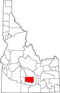 Location of Lincoln County in Idaho
This is a list of the National Register of Historic Places listings in Lincoln County, Idaho.
This is intended to be a complete list of the properties and districts on the National Register of Historic Places in Lincoln County, Idaho, United States. Latitude and longitude coordinates are provided for many National Register properties and districts; these locations may be seen together in a Google map.[1]
There are 41 properties and districts listed on the National Register in the county. More may be added; properties and districts nationwide are added to the Register weekly.[2]
-
- This National Park Service list is complete through NPS recent listings posted November 10, 2011.[3]
Current listings
[4] Landmark name [5] Image Date listed Location City or town Summary 1 American Legion Hall September 8, 1983 107 W. A St.
42°56′04″N 114°24′25″W / 42.934444°N 114.406944°WShoshone 2 Jose and Gertrude Anasola House September 8, 1983 120 N. Alta St.
42°56′13″N 114°24′11″W / 42.936944°N 114.403056°WShoshone 3 Galo Arambarri Boarding House September 8, 1983 109 N. Greenwood St.
42°56′15″N 114°24′17″W / 42.9375°N 114.404722°WShoshone 4 S.A. Bate Barn and Chicken House September 8, 1983 Southeast of Dietrich
42°53′05″N 114°15′14″W / 42.884722°N 114.253889°WDietrich 5 W. H. Baugh House September 8, 1983 East of Shoshone
42°57′38″N 114°18′36″W / 42.960556°N 114.31°WShoshone 6 Ignacio Berriochoa Farm September 8, 1983 Northwest of Dietrich
42°55′10″N 114°18′03″W / 42.919444°N 114.300833°WDietrich 7 Birdie Boussuet Farm September 8, 1983 West of Richfield
43°01′54″N 114°11′24″W / 43.031667°N 114.19°WRichfield 8 Tom Byrne House September 8, 1983 Northeast of Shoshone
43°07′45″N 114°15′54″W / 43.129167°N 114.265°WShoshone 9 Custer Slaughter House September 8, 1983 West of Shoshone
42°56′41″N 114°24′41″W / 42.944722°N 114.411389°WShoshone 10 Darrah House and Water Tank House September 8, 1983 Northeast of Shoshone
42°58′55″N 114°21′32″W / 42.981944°N 114.358889°WShoshone 11 Ben Darrah Water Tank and Well House September 8, 1983 North of Shoshone
43°01′34″N 114°24′58″W / 43.026111°N 114.416111°WShoshone 12 Charles W. Dill House September 8, 1983 East of Shoshone
42°55′08″N 114°21′45″W / 42.918889°N 114.3625°WShoshone 13 Alvin Eskelton Barn September 8, 1983 Northwest of Richfield
43°05′34″N 114°10′25″W / 43.092778°N 114.173611°WRichfield 14 George H. Gaches Cellar and Ice House September 8, 1983 Northwest of Shoshone
43°01′07″N 114°26′43″W / 43.018611°N 114.445278°WShoshone 15 Thomas Gooding Water Tank House September 8, 1983 Northwest of Shoshone
43°01′32″N 114°30′55″W / 43.025556°N 114.515278°WShoshone 16 Gehrig Gottfried Cabin September 8, 1983 Northwest of Shoshone
43°02′45″N 114°19′33″W / 43.045833°N 114.325833°WShoshone 17 Daniel A. Hunt House September 8, 1983 Southwest of Dietrich
42°52′06″N 114°17′41″W / 42.868333°N 114.294722°WDietrich 18 J.C. Penney Company Building September 8, 1983 104 S. Rail St.
42°56′06″N 114°24′21″W / 42.935°N 114.405833°WShoshone 19 Louis Johnson Barn September 8, 1983 Southwest of Richfield
43°01′36″N 114°13′45″W / 43.026667°N 114.229167°WRichfield 20 Louis Johnson Water Tank House September 8, 1983 West of Richfield
43°01′30″N 114°14′37″W / 43.025°N 114.243611°WRichfield 21 Quet Johnson Farm September 8, 1983 Northwest of Richfield
43°05′55″N 114°10′10″W / 43.098611°N 114.169444°WRichfield 22 W.S. Kohl Barn September 8, 1983 Northeast of Richfield
43°04′25″N 114°07′54″W / 43.073611°N 114.131667°WRichfield 23 James H. Lane Barn 
September 8, 1983 South of Richfield
43°02′33″N 114°09′07″W / 43.0425°N 114.151944°WRichfield 24 Lemmon Hardware Store September 8, 1983 Main St. and Nez Perce Ave.
43°02′58″N 114°09′08″W / 43.049444°N 114.152222°WRichfield 25 W.H. Murphy House September 8, 1983 607 S. Greenwood St.
42°55′53″N 114°24′30″W / 42.931389°N 114.408333°WShoshone 26 Myers School September 8, 1983 West of Shoshone
42°57′28″N 114°29′20″W / 42.957778°N 114.488889°WShoshone 27 A.G. Newman House September 8, 1983 309 E. C St.
42°55′55″N 114°24′16″W / 42.931944°N 114.404444°WShoshone 28 Thomas Olley House September 8, 1983 522 N. Apple St.
42°56′28″N 114°24′20″W / 42.941111°N 114.405556°WShoshone 29 Jack Oughton House September 8, 1983 123 N. Beverly St.
42°56′13″N 114°24′08″W / 42.936944°N 114.402222°WShoshone 30 Denton J. Paul Water Tank September 8, 1983 East of Dietrich
42°54′31″N 114°14′28″W / 42.908611°N 114.241111°WDietrich 31 Kenneth G. Phelphs Barn September 8, 1983 West of Richfield
43°02′58″N 114°10′25″W / 43.049444°N 114.173611°WRichfield 32 Purdum Livery Stable September 15, 1983 113 N. Rail St., E.
42°56′09″N 114°24′16″W / 42.935833°N 114.404444°WShoshone 33 Richfield Pump House September 8, 1983 Southeast of Richfield
43°02′30″N 114°09′01″W / 43.041667°N 114.150278°WRichfield 34 William M. Ritter House September 8, 1983 Northeast of Shoshone
43°01′10″N 114°21′13″W / 43.019444°N 114.353611°WShoshone 35 Shoshone Historic District June 27, 1975 Irregular pattern, including the northern bank of the Little Wood River and W. D St.; also 115 N. Greenwood St.
42°56′02″N 114°24′28″W / 42.93387°N 114.40766°WShoshone Greenwood St. address represents a boundary increase 36 Arthur D. Silva Flume September 8, 1983 Northwest of Shoshone
42°59′26″N 114°26′59″W / 42.990556°N 114.449722°WShoshone 37 Arthur D. Silva Ranch September 8, 1983 Northwest of Shoshone
42°59′37″N 114°27′14″W / 42.993611°N 114.453889°WShoshone 38 Arthur D. Silva Water Tank September 8, 1983 Northwest of Shoshone
42°59′43″N 114°27′14″W / 42.995278°N 114.453889°WShoshone 39 Manuel Silva Barn September 8, 1983 East of Shoshone
42°55′34″N 114°21′35″W / 42.926111°N 114.359722°WShoshone 40 John G. Turner House September 8, 1983 West of Richfield
43°00′20″N 114°14′23″W / 43.005556°N 114.239722°WRichfield 41 Wood River Center Grange No. 87 July 3, 2003 375 W. 4 Mile Rd.
43°00′12″N 114°28′43″W / 43.003333°N 114.478611°WShoshone See also
References
- ^ The latitude and longitude information provided in this table was derived originally from the National Register Information System, which has been found to be fairly accurate for about 99% of listings. For about 1% of NRIS original coordinates, experience has shown that one or both coordinates are typos or otherwise extremely far off; some corrections may have been made. A more subtle problem causes many locations to be off by up to 150 yards, depending on location in the country: most NRIS coordinates were derived from tracing out latitude and longitudes off of USGS topographical quadrant maps created under the North American Datum of 1927, which differs from the current, highly accurate WGS84 GPS system used by Google maps. Chicago is about right, but NRIS longitudes in Washington are higher by about 4.5 seconds, and are lower by about 2.0 seconds in Maine. Latitudes differ by about 1.0 second in Florida. Some locations in this table may have been corrected to current GPS standards.
- ^ "National Register of Historic Places: Weekly List Actions". National Park Service. http://www.cr.nps.gov/nr/nrlist.htm. Retrieved March 29, 2009.
- ^ "National Register of Historic Places: Weekly List Actions". National Park Service, United States Department of the Interior. Retrieved on November 10, 2011.
- ^ Numbers represent an ordering by significant words. Various colorings, defined here, differentiate National Historic Landmark sites and National Register of Historic Places Districts from other NRHP buildings, structures, sites or objects.
- ^ "National Register Information System". National Register of Historic Places. National Park Service. . http://nrhp.focus.nps.gov/natreg/docs/All_Data.html.
Properties on the National Register of Historic Places in Idaho  Ada • Adams • Bannock • Bear Lake • Benewah • Bingham • Blaine • Boise • Bonner • Bonneville • Boundary • Butte • Camas • Canyon • Caribou • Cassia • Clark • Clearwater • Custer • Elmore • Franklin • Fremont • Gem • Gooding • Idaho • Jefferson • Jerome • Kootenai • Latah • Lemhi • Lewis • Lincoln • Madison • Minidoka • Nez Perce • Oneida • Owyhee • Payette • Power • Shoshone • Teton • Twin Falls • Valley • Washington
U.S. National Register of Historic Places Topics Lists by states Alabama • Alaska • Arizona • Arkansas • California • Colorado • Connecticut • Delaware • Florida • Georgia • Hawaii • Idaho • Illinois • Indiana • Iowa • Kansas • Kentucky • Louisiana • Maine • Maryland • Massachusetts • Michigan • Minnesota • Mississippi • Missouri • Montana • Nebraska • Nevada • New Hampshire • New Jersey • New Mexico • New York • North Carolina • North Dakota • Ohio • Oklahoma • Oregon • Pennsylvania • Rhode Island • South Carolina • South Dakota • Tennessee • Texas • Utah • Vermont • Virginia • Washington • West Virginia • Wisconsin • WyomingLists by territories Lists by associated states Other Municipalities and communities of Lincoln County, Idaho Cities 
Unincorporated
communityCategories:- National Register of Historic Places in Idaho by county
- Lincoln County, Idaho
-


Wikimedia Foundation. 2010.