- National Register of Historic Places listings in Twin Falls County, Idaho
-
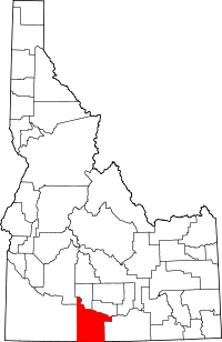 Location of Twin Falls County in Idaho
This is a list of the National Register of Historic Places listings in Twin Falls County, Idaho.
This is intended to be a complete list of the properties and districts on the National Register of Historic Places in Twin Falls County, Idaho, United States. Latitude and longitude coordinates are provided for many National Register properties and districts; these locations may be seen together in a Google map.[1]
There are 39 properties and districts listed on the National Register in the county. More may be added; properties and districts nationwide are added to the Register weekly.[2]
-
- This National Park Service list is complete through NPS recent listings posted November 10, 2011.[3]
Current listings
[4] Landmark name [5] Image Date listed Location City or town Summary 1 James Alvis House May 23, 1980 1311 Pole Line Rd.
42°35′32″N 114°27′20″W / 42.592222°N 114.455556°WTwin Falls 2 Bickel School August 17, 1990 607 2nd Ave., E.
42°33′08″N 114°27′41″W / 42.552222°N 114.461389°WTwin Falls 3 T. P. Bowlby Barn September 7, 1983 Northeast of Buhl
42°37′23″N 114°42′17″W / 42.623056°N 114.704722°WBuhl 4 Buhl City Hall February 8, 1978 Broadway and Elm St.
42°36′00″N 114°45′38″W / 42.6°N 114.760556°WBuhl 5 Buhl IOOF Building 
December 27, 1984 1014-16 Main St.
42°35′56″N 114°45′35″W / 42.598889°N 114.759722°WBuhl 6 Caldron Linn June 27, 1972 2 miles east of Murtaugh
42°29′53″N 114°09′46″W / 42.498056°N 114.162778°WMurtaugh Extends into Jerome County 7 Cedar Draw School August 8, 1991 4300 N. Rd. between 1900 and 2000 E.
42°37′20″N 114°40′03″W / 42.622222°N 114.6675°WBuhl 8 Dau-Webbenhorst Barn September 7, 1983 Southeast of Buhl
42°34′40″N 114°44′22″W / 42.577778°N 114.739444°WBuhl 9 Achille Duquesne House September 23, 1993 710 W. Midway
42°34′17″N 114°36′49″W / 42.571389°N 114.613611°WFiler 10 Hollister School August 8, 1991 2464 Salmon Ave.
42°21′24″N 114°35′31″W / 42.356667°N 114.591944°WHollister 11 Hotel Buhl 
September 12, 1985 1004 Main St.
42°35′56″N 114°45′35″W / 42.598889°N 114.759722°WBuhl 12 Idaho Power Substation June 23, 1978 Van Buren St. and Filer Ave.
42°34′14″N 114°28′12″W / 42.570556°N 114.47°WTwin Falls 13 Kimberly High School August 17, 1990 141 Center St., W.
42°32′00″N 114°21′55″W / 42.533333°N 114.365278°WKimberly 14 Rudolf Kunze Barn April 5, 1994 Northeast of Buhl
42°35′05″N 114°42′42″W / 42.584722°N 114.711667°WBuhl 15 Lincoln School August 17, 1990 238 7th St.
42°33′42″N 114°28′28″W / 42.561667°N 114.474444°WTwin Falls 16 Lincoln Street Electric Streetlights April 27, 1992 105, 120, 147, 174, 189, 210, 217, 242, 275, and 290 Lincoln St.
42°33′51″N 114°27′38″W / 42.564167°N 114.460556°WTwin Falls 17 Art and Frieda Maxwell Barn September 7, 1983 Southeast of Buhl
42°35′25″N 114°42′36″W / 42.590278°N 114.71°WBuhl 18 Robert McCollum House November 4, 1982 708 E. Shoshone St.
42°33′36″N 114°27′48″W / 42.56°N 114.463333°WTwin Falls 19 Milner Dam and the Twin Falls Main Canal 
July 10, 1986 Twin Falls Main Canal between Murtaugh and Milner Lakes
42°29′58″N 114°04′50″W / 42.499444°N 114.080556°WMurtaugh Extends into Jerome County 20 Burton Morse House September 23, 1993 136 10th Ave., N.
42°33′45″N 114°27′41″W / 42.5625°N 114.461389°WTwin Falls 21 D. H. Peck House September 23, 1993 207 E. 8th Ave.
42°33′35″N 114°27′40″W / 42.559722°N 114.461111°WTwin Falls 22 Pleasant Valley School August 8, 1991 3501 E. 3100 N.
42°26′48″N 114°21′45″W / 42.446667°N 114.3625°WKimberly 23 Pleasant View School August 8, 1991 2500 E. 3600 N.
42°31′12″N 114°33′30″W / 42.52°N 114.558333°WTwin Falls 24 Walter Priebe House September 23, 1993 155 7th Ave. E.
42°33′34″N 114°27′44″W / 42.559444°N 114.462222°WTwin Falls 25 Ramona Theater December 22, 1976 113 Broadway
42°35′55″N 114°45′31″W / 42.598611°N 114.758611°WBuhl 26 Salmon Falls Dam May 15, 2009 Three Creek Highway
42°12′44″N 114°44′03″W / 42.212131°N 114.734208°WRogerson 27 Henry Schick Barn September 7, 1983 Southeast of Buhl
42°34′46″N 114°42′42″W / 42.579444°N 114.711667°WBuhl 28 C. Harvey Smith House April 3, 1978 255 4th Ave., E.
42°33′23″N 114°27′51″W / 42.556389°N 114.464167°WTwin Falls 29 Stricker Store and Farm August 30, 1979 North of Rock Creek
42°27′33″N 114°19′16″W / 42.459167°N 114.321111°WTwin Falls 30 Toana Freight Wagon Road Historic District November 29, 2006 Generally runs south to north from Nevada-Idaho state line to the Snake River
42°21′40″N 114°52′04″W / 42.361111°N 114.867778°WCastleford 31 Twin Falls Bank and Trust Company Building September 4, 1986 102 Main Ave. S
42°33′20″N 114°28′08″W / 42.555556°N 114.468889°WTwin Falls 32 Twin Falls Canal Company Building 
August 30, 1996 162 2nd St., W.
42°33′21″N 114°28′17″W / 42.555833°N 114.471389°WTwin Falls 33 Twin Falls City Park Historic District March 30, 1978 2nd N., 2nd E., and Shoshone Sts., 4th and 6th Aves.
42°33′31″N 114°27′57″W / 42.558611°N 114.465833°WTwin Falls 34 Twin Falls Downtown Historic District February 4, 2000 Roughly bounded by 2nd Ave., N., 2nd St., E., 2nd St., W., 2nd St., S., 3rd Ave., S., and 3rd St., W.
42°33′23″N 114°28′14″W / 42.556389°N 114.470556°WTwin Falls 35 Twin Falls Milling and Elevator Company Warehouse August 31, 1995 516 2nd St., S.
42°33′07″N 114°28′19″W / 42.551944°N 114.471944°WTwin Falls 36 Twin Falls Original Townsite Residential Historic District November 30, 2001 Roughly bounded by Blue Lakes Ave., Addison Ave., 2nd Ave. E, and 2nd Ave. W
42°33′25″N 114°28′03″W / 42.556944°N 114.4675°WTwin Falls 37 Twin Falls Warehouse Historic District January 15, 1997 Roughly bounded by 2nd Ave., 4th St., S. and W., and Minidoka Ave.
42°33′13″N 114°28′17″W / 42.553611°N 114.471389°WTwin Falls 38 Union School March 20, 2003 21337 U.S. Route 30
42°33′49″N 114°32′56″W / 42.563611°N 114.548889°WFiler 39 US Post Office-Buhl Main March 16, 1989 830 Main
42°36′00″N 114°45′28″W / 42.6°N 114.757778°WBuhl See also
References
- ^ The latitude and longitude information provided in this table was derived originally from the National Register Information System, which has been found to be fairly accurate for about 99% of listings. For about 1% of NRIS original coordinates, experience has shown that one or both coordinates are typos or otherwise extremely far off; some corrections may have been made. A more subtle problem causes many locations to be off by up to 150 yards, depending on location in the country: most NRIS coordinates were derived from tracing out latitude and longitudes off of USGS topographical quadrant maps created under the North American Datum of 1927, which differs from the current, highly accurate WGS84 GPS system used by Google maps. Chicago is about right, but NRIS longitudes in Washington are higher by about 4.5 seconds, and are lower by about 2.0 seconds in Maine. Latitudes differ by about 1.0 second in Florida. Some locations in this table may have been corrected to current GPS standards.
- ^ "National Register of Historic Places: Weekly List Actions". National Park Service. http://www.cr.nps.gov/nr/nrlist.htm. Retrieved March 29, 2009.
- ^ "National Register of Historic Places: Weekly List Actions". National Park Service, United States Department of the Interior. Retrieved on November 10, 2011.
- ^ Numbers represent an ordering by significant words. Various colorings, defined here, differentiate National Historic Landmark sites and National Register of Historic Places Districts from other NRHP buildings, structures, sites or objects.
- ^ "National Register Information System". National Register of Historic Places. National Park Service. . http://nrhp.focus.nps.gov/natreg/docs/All_Data.html.
Properties on the National Register of Historic Places in Idaho  Ada • Adams • Bannock • Bear Lake • Benewah • Bingham • Blaine • Boise • Bonner • Bonneville • Boundary • Butte • Camas • Canyon • Caribou • Cassia • Clark • Clearwater • Custer • Elmore • Franklin • Fremont • Gem • Gooding • Idaho • Jefferson • Jerome • Kootenai • Latah • Lemhi • Lewis • Lincoln • Madison • Minidoka • Nez Perce • Oneida • Owyhee • Payette • Power • Shoshone • Teton • Twin Falls • Valley • Washington
U.S. National Register of Historic Places Topics Lists by states Alabama • Alaska • Arizona • Arkansas • California • Colorado • Connecticut • Delaware • Florida • Georgia • Hawaii • Idaho • Illinois • Indiana • Iowa • Kansas • Kentucky • Louisiana • Maine • Maryland • Massachusetts • Michigan • Minnesota • Mississippi • Missouri • Montana • Nebraska • Nevada • New Hampshire • New Jersey • New Mexico • New York • North Carolina • North Dakota • Ohio • Oklahoma • Oregon • Pennsylvania • Rhode Island • South Carolina • South Dakota • Tennessee • Texas • Utah • Vermont • Virginia • Washington • West Virginia • Wisconsin • WyomingLists by territories Lists by associated states Other Municipalities and communities of Twin Falls County, Idaho Cities Buhl | Castleford | Filer | Hansen | Hollister | Kimberly | Murtaugh | Twin Falls

Unincorporated
communityCategories:- National Register of Historic Places in Idaho by county
- Twin Falls County, Idaho
-


Wikimedia Foundation. 2010.