- National Register of Historic Places listings in Payette County, Idaho
-
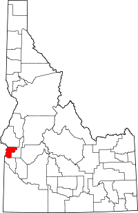 Location of Payette County in Idaho
This is a list of the National Register of Historic Places listings in Payette County, Idaho.
This is intended to be a complete list of the properties on the National Register of Historic Places in Payette County, Idaho, United States. Latitude and longitude coordinates are provided for many National Register properties and districts; these locations may be seen together in a Google map.[1]
There are 14 properties listed on the National Register in the county. More may be added; properties and districts nationwide are added to the Register weekly.[2]
-
- This National Park Service list is complete through NPS recent listings posted November 10, 2011.[3]
Current listings
[4] Landmark name [5] Image Date listed Location City or town Summary 1 David C. Chase House February 7, 1978 307 9th St., N.
44°04′43″N 116°55′58″W / 44.078611°N 116.932778°WPayette 2 Coughanour Apartment Block May 23, 1978 700-718 1st Ave., N.
44°04′33″N 116°56′04″W / 44.075833°N 116.934444°WPayette 3 N.A. Jacobsen Building 
November 17, 1982 N. 8th St. and 1st Ave.
44°04′25″N 116°56′06″W / 44.073611°N 116.935°WPayette 4 N.A. Jacobsen House January 7, 1998 1115 1st. Ave., N.
44°04′35″N 116°55′45″W / 44.076389°N 116.929167°WPayette 5 Methodist Episcopal Church of Payette October 5, 1977 1st Ave., S. and 9th St.
44°04′26″N 116°55′58″W / 44.073889°N 116.932778°WPayette 6 A.B. Moss Building February 8, 1978 137 N. 8th St.
44°04′37″N 116°56′04″W / 44.076944°N 116.934444°WPayette 7 New Plymouth Congregational Church November 17, 1982 Southwest Ave. between West Park and Plymouth
43°58′11″N 116°49′11″W / 43.969722°N 116.819722°WNew Plymouth 8 J.C. Palumbo Fruit Company Packing Warehouse Building November 17, 1982 2nd Ave. and 6th St.
44°04′23″N 116°56′12″W / 44.073056°N 116.936667°WPayette 9 Payette City Hall and Courthouse May 14, 1979 3rd Ave. and 8th St.
44°04′41″N 116°56′01″W / 44.078056°N 116.933611°WPayette 10 Portia Club April 7, 2010 225 N. 9th St.
44°04′38″N 116°56′01″W / 44.077303°N 116.933531°WPayette 11 St. James Episcopal Church April 20, 1978 1st Ave., N. and 10th St.
44°04′34″N 116°55′50″W / 44.076111°N 116.930556°WPayette 12 US Post Office-Payette Main March 16, 1989 915 Center Ave.
44°04′31″N 116°55′56″W / 44.075278°N 116.932222°WPayette 13 Grant Whitney House February 23, 1978 1015 7th Ave., N.
44°04′56″N 116°55′49″W / 44.082222°N 116.930278°WPayette 14 Woodward Building 
April 26, 1978 23 8th St.
44°04′28″N 116°56′01″W / 44.074444°N 116.933611°WPayette See also
References
- ^ The latitude and longitude information provided in this table was derived originally from the National Register Information System, which has been found to be fairly accurate for about 99% of listings. For about 1% of NRIS original coordinates, experience has shown that one or both coordinates are typos or otherwise extremely far off; some corrections may have been made. A more subtle problem causes many locations to be off by up to 150 yards, depending on location in the country: most NRIS coordinates were derived from tracing out latitude and longitudes off of USGS topographical quadrant maps created under the North American Datum of 1927, which differs from the current, highly accurate WGS84 GPS system used by Google maps. Chicago is about right, but NRIS longitudes in Washington are higher by about 4.5 seconds, and are lower by about 2.0 seconds in Maine. Latitudes differ by about 1.0 second in Florida. Some locations in this table may have been corrected to current GPS standards.
- ^ "National Register of Historic Places: Weekly List Actions". National Park Service. http://www.cr.nps.gov/nr/nrlist.htm. Retrieved March 29, 2009.
- ^ "National Register of Historic Places: Weekly List Actions". National Park Service, United States Department of the Interior. Retrieved on November 10, 2011.
- ^ Numbers represent an ordering by significant words. Various colorings, defined here, differentiate National Historic Landmark sites and National Register of Historic Places Districts from other NRHP buildings, structures, sites or objects.
- ^ "National Register Information System". National Register of Historic Places. National Park Service. . http://nrhp.focus.nps.gov/natreg/docs/All_Data.html.
Properties on the National Register of Historic Places in Idaho  Ada • Adams • Bannock • Bear Lake • Benewah • Bingham • Blaine • Boise • Bonner • Bonneville • Boundary • Butte • Camas • Canyon • Caribou • Cassia • Clark • Clearwater • Custer • Elmore • Franklin • Fremont • Gem • Gooding • Idaho • Jefferson • Jerome • Kootenai • Latah • Lemhi • Lewis • Lincoln • Madison • Minidoka • Nez Perce • Oneida • Owyhee • Payette • Power • Shoshone • Teton • Twin Falls • Valley • Washington
U.S. National Register of Historic Places Topics Lists by states Alabama • Alaska • Arizona • Arkansas • California • Colorado • Connecticut • Delaware • Florida • Georgia • Hawaii • Idaho • Illinois • Indiana • Iowa • Kansas • Kentucky • Louisiana • Maine • Maryland • Massachusetts • Michigan • Minnesota • Mississippi • Missouri • Montana • Nebraska • Nevada • New Hampshire • New Jersey • New Mexico • New York • North Carolina • North Dakota • Ohio • Oklahoma • Oregon • Pennsylvania • Rhode Island • South Carolina • South Dakota • Tennessee • Texas • Utah • Vermont • Virginia • Washington • West Virginia • Wisconsin • WyomingLists by territories Lists by associated states Other Municipalities and communities of Payette County, Idaho Cities  Categories:
- National Register of Historic Places in Idaho by county
- Payette County, Idaho
-


Wikimedia Foundation. 2010.