- National Register of Historic Places listings in Payne County, Oklahoma
-
 Location of Payne County in Oklahoma
This is a list of the National Register of Historic Places listings in Payne County, Oklahoma.
This is intended to be a complete list of the properties and districts on the National Register of Historic Places in Payne County, Oklahoma, United States. The locations of National Register properties and districts for which the latitude and longitude coordinates are included below, may be seen in a Google map.[1]
There are 26 properties and districts listed on the National Register in the county.
-
- This National Park Service list is complete through NPS recent listings posted November 10, 2011.[2]
Current listings
[3] Landmark name [4] Image Date listed Location City or town Summary 1 The Bassett House December 3, 2009 1100 E. 9th Pl.
35°58′20″N 96°45′23″W / 35.972158°N 96.756464°WCushing 2 James E. Berry House November 21, 1980 502 S. Duck St.
36°06′59″N 97°03′44″W / 36.116389°N 97.062222°WStillwater 3 Luke D. Berry House December 11, 2007 621 E. Broadway St.
35°58′47″N 96°45′55″W / 35.979722°N 96.765278°WCushing 4 Campus Fire Station December 7, 2004 600 W. University Ave.
36°07′12″N 97°03′54″W / 36.12°N 97.065°WStillwater 5 Citizens Bank Building February 24, 1981 107 E. 9th St.
36°06′46″N 97°03′29″W / 36.112778°N 97.058056°WStillwater 6 Cottonwood Community Center March 13, 1980 Northwest of Stillwater
36°08′43″N 97°09′29″W / 36.145278°N 97.158056°WStillwater 7 Cushing American Legion Building June 5, 2003 212 S. Noble
35°58′41″N 96°46′10″W / 35.978056°N 96.769444°WCushing 8 Cushing Armory May 20, 1994 218 S. Little Ave.
35°58′42″N 96°46′00″W / 35.978333°N 96.766667°WCushing 9 William Frick House September 8, 1980 1016 S. West St.
36°06′36″N 97°03′47″W / 36.11°N 97.063056°WStillwater 10 Hoke Building September 12, 1983 121 W. 7th Ave.
36°06′51″N 97°03′34″W / 36.114167°N 97.059444°WStillwater 11 Hopkins Sandstone House and Farmstead May 7, 1979 Northeast of Ripley
36°02′30″N 96°51′42″W / 36.041667°N 96.861667°WRipley 12 Irvings Castle February 17, 1978 2.5 miles (4 km) south of Ingalls
36°03′46″N 96°53′33″W / 36.062778°N 96.8925°WIngalls 13 Magruder Plots August 29, 1979 Oklahoma State University
36°07′01″N 97°05′15″W / 36.116944°N 97.0875°WStillwater 14 Murphy House September 18, 1986 419 S. Monroe
36°07′00″N 97°04′16″W / 36.116667°N 97.071111°WStillwater 15 Oklahoma A & M College Agronomy Barn and Seed House May 27, 2004 2902 W. 6th St. Building #610
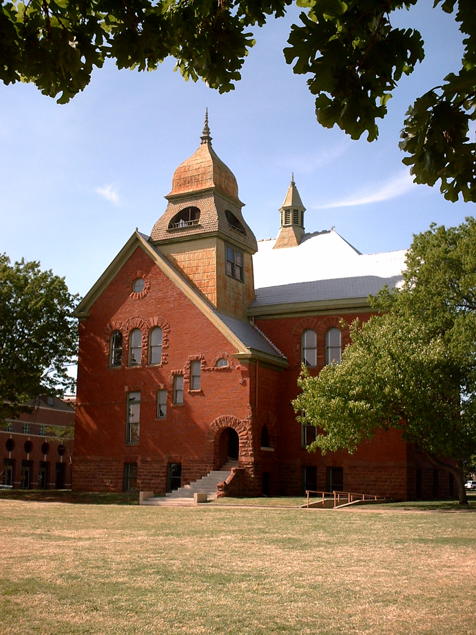
36°07′02″N 97°05′37″W / 36.117222°N 97.093611°WStillwater 16 Old Central, Oklahoma State University 
July 27, 1971 Oklahoma State University campus
36°07′14″N 97°03′59″W / 36.120556°N 97.066389°WStillwater 17 Payne County Courthouse 
August 23, 1984 606 S. Husband St.
36°06′55″N 97°03′37″W / 36.115278°N 97.060278°WStillwater 18 Perkins Downtown Historic District December 28, 2000 100 block of Main St. bounded by Stumbo and Thomas Sts.
35°58′24″N 97°02′01″W / 35.973333°N 97.033611°WPerkins 19 Pleasant Valley School January 25, 1991 1901 S. Sangre Rd.
36°06′02″N 97°06′16″W / 36.100556°N 97.104444°WStillwater 20 Josephine Reifsnyder Luston House February 23, 2009 2119 Sherwood
36°07′19″N 97°05′02″W / 36.121944°N 97.083889°WStillwater 21 Selph Building September 12, 1983 119 W. 7th Ave.
36°06′51″N 97°03′33″W / 36.114167°N 97.059167°WStillwater 22 Stillwater Santa Fe Depot March 3, 1980 400 E. 10th St.
36°06′46″N 97°03′16″W / 36.112778°N 97.054444°WStillwater 23 Jim Thorpe House March 24, 1971 704 E. Boston St.
36°06′49″N 96°48′38″W / 36.113611°N 96.810556°WYale 24 Christian K. Usher Luston House February 23, 2009 1135 E. Moses
35°58′52″N 96°45′21″W / 35.981111°N 96.755833°WCushing 25 Walker Building September 12, 1983 117 W. 7th Ave.
36°06′51″N 97°03′33″W / 36.114167°N 97.059167°WStillwater 26 White Cloud Lodge September 3, 2010 820 E. 146th St.
35°56′57″N 97°02′53″W / 35.949167°N 97.048056°WPerkins See also
- List of National Historic Landmarks in Oklahoma
- National Register of Historic Places listings in Oklahoma
References
- ^ The latitude and longitude information provided in this table was derived originally from the National Register Information System, which has been found to be fairly accurate for about 99% of listings. For about 1% of NRIS original coordinates, experience has shown that one or both coordinates are typos or otherwise extremely far off; some corrections may have been made. A more subtle problem causes many locations to be off by up to 150 yards, depending on location in the country: most NRIS coordinates were derived from tracing out latitude and longitudes off of USGS topographical quadrant maps created under the North American Datum of 1927, which differs from the current, highly accurate WGS84 GPS system used by Google maps. Chicago is about right, but NRIS longitudes in Washington are higher by about 4.5 seconds, and are lower by about 2.0 seconds in Maine. Latitudes differ by about 1.0 second in Florida. Some locations in this table may have been corrected to current GPS standards.
- ^ "National Register of Historic Places: Weekly List Actions". National Park Service, United States Department of the Interior. Retrieved on November 10, 2011.
- ^ Numbers represent an ordering by significant words. Various colorings, defined here, differentiate National Historic Landmark sites and National Register of Historic Places Districts from other NRHP buildings, structures, sites or objects.
- ^ "National Register Information System". National Register of Historic Places. National Park Service. . http://nrhp.focus.nps.gov/natreg/docs/All_Data.html.
U.S. National Register of Historic Places Topics Lists by states Alabama • Alaska • Arizona • Arkansas • California • Colorado • Connecticut • Delaware • Florida • Georgia • Hawaii • Idaho • Illinois • Indiana • Iowa • Kansas • Kentucky • Louisiana • Maine • Maryland • Massachusetts • Michigan • Minnesota • Mississippi • Missouri • Montana • Nebraska • Nevada • New Hampshire • New Jersey • New Mexico • New York • North Carolina • North Dakota • Ohio • Oklahoma • Oregon • Pennsylvania • Rhode Island • South Carolina • South Dakota • Tennessee • Texas • Utah • Vermont • Virginia • Washington • West Virginia • Wisconsin • WyomingLists by territories Lists by associated states Other Municipalities and communities of Payne County, Oklahoma Cities Cushing | Drumright‡ | Perkins | Stillwater | Yale

Towns Unincorporated
communitiesGhost town Footnotes ‡This populated place also has portions in an adjacent county or counties
Categories:- Payne County, Oklahoma
- National Register of Historic Places in Oklahoma by county
-


Wikimedia Foundation. 2010.