- National Register of Historic Places listings in Lucas County, Iowa
-
 Location of Lucas County in Iowa
This is a list of the National Register of Historic Places listings in Lucas County, Iowa.
This is intended to be a complete list of the properties and districts on the National Register of Historic Places in Lucas County, Iowa, United States. Latitude and longitude coordinates are provided for many National Register properties and districts; these locations may be seen together in a Google map.[1]
There are 15 properties listed on the National Register in the county.
-
- This National Park Service list is complete through NPS recent listings posted November 10, 2011.[2]
[3] Landmark name [4] Image Date listed Location City or town Summary 1 Burlington Railroad Overpass May 15, 1998 County Road S23 over the Burlington Northern railroad line
41°02′27″N 93°21′57″W / 41.040833°N 93.365833°WChariton 2 Carl L. Caviness Post 102, American Legion September 6, 2006 201 S. Main St.
41°00′53″N 93°18′31″W / 41.014722°N 93.308611°WChariton 3 Chariton Cemetery Historic District March 10, 2010 929 S. Main St.
41°00′15″N 93°18′30″W / 41.004233°N 93.308208°WChariton 4 Chariton City Hall and Fire Station September 6, 2006 115 S. Main St.
41°00′56″N 93°18′31″W / 41.015556°N 93.308611°WChariton 5 Chariton Free Public Library August 24, 2005 803 Braden
41°01′03″N 93°18′21″W / 41.0175°N 93.305833°WChariton 6 Chariton Herald-Patriot Building September 6, 2006 815 Braden Ave.
41°01′03″N 93°18′22″W / 41.0175°N 93.306111°WChariton 7 Chariton Masonic Temple September 6, 2006 821 Armory Ave.
41°00′51″N 93°18′24″W / 41.014167°N 93.306667°WChariton 8 Chicago, Burlington, and Quincy Freight House-Chariton August 28, 2003 Junction of Auburn and Brookdale
41°01′07″N 93°18′38″W / 41.018611°N 93.310556°WChariton 9 J. T. and Mollie Crozier House October 6, 2011 627 Ilion Ave.
41°01′31″N 93°18′11″W / 41.025278°N 93.303056°WChariton Architectural Career of William L. Perkins in Iowa: 1917-1957 MPS 10 First United Methodist Church January 24, 2002 923 Roland
41°01′01″N 93°18′28″W / 41.016944°N 93.307778°WChariton 11 Hotel Charitone September 6, 2006 831 Braden Ave.
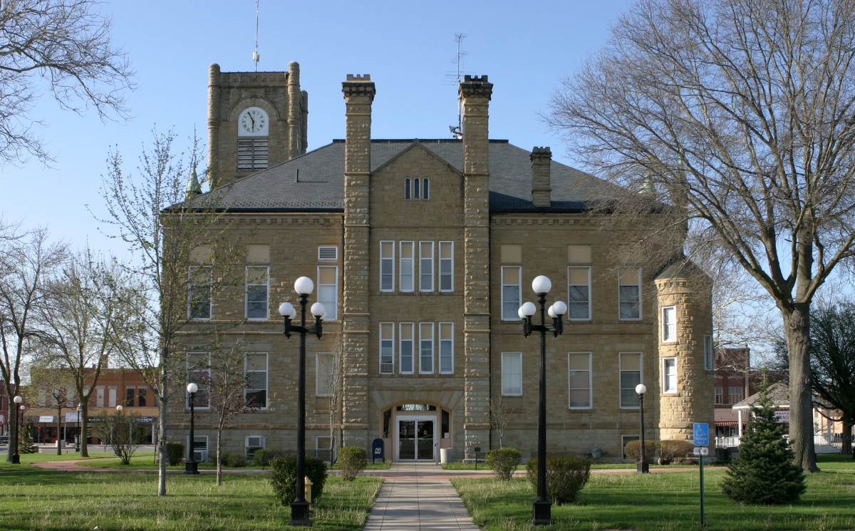
41°01′03″N 93°18′24″W / 41.0175°N 93.306667°WChariton 12 Lucas County Courthouse 
July 2, 1981 Courthouse Sq.
41°00′55″N 93°18′25″W / 41.015278°N 93.306944°WChariton 13 O. E. Payne House July 17, 1979 705 E. Auburn Ave.
41°01′46″N 93°18′12″W / 41.029444°N 93.303333°WChariton 14 A. J. Stephens House November 16, 1987 123 17th St.
41°00′56″N 93°19′10″W / 41.015556°N 93.319444°WChariton 15 Williamson School May 1, 1998 301 Williamson Ave.
41°05′22″N 93°15′36″W / 41.089444°N 93.26°WWilliamson See also
References
- ^ The latitude and longitude information provided in this table was derived originally from the National Register Information System, which has been found to be fairly accurate for about 99% of listings. For about 1% of NRIS original coordinates, experience has shown that one or both coordinates are typos or otherwise extremely far off; some corrections may have been made. A more subtle problem causes many locations to be off by up to 150 yards, depending on location in the country: most NRIS coordinates were derived from tracing out latitude and longitudes off of USGS topographical quadrant maps created under North American Datum of 1927, which differs from the current, highly accurate GPS system used by Google maps. Chicago is about right, but NRIS longitudes in Washington are higher by about 4.5 seconds, and are lower by about 2.0 seconds in Maine. Latitudes differ by about 1.0 second in Florida. Some locations in this table may have been corrected to current GPS standards.
- ^ "National Register of Historic Places: Weekly List Actions". National Park Service, United States Department of the Interior. Retrieved on November 10, 2011.
- ^ Numbers represent an ordering by significant words. Various colorings, defined here, differentiate National Historic Landmark sites and National Register of Historic Places Districts from other NRHP buildings, structures, sites or objects.
- ^ "National Register Information System". National Register of Historic Places. National Park Service. . http://nrhp.focus.nps.gov/natreg/docs/All_Data.html.
U.S. National Register of Historic Places Topics Lists by states Alabama • Alaska • Arizona • Arkansas • California • Colorado • Connecticut • Delaware • Florida • Georgia • Hawaii • Idaho • Illinois • Indiana • Iowa • Kansas • Kentucky • Louisiana • Maine • Maryland • Massachusetts • Michigan • Minnesota • Mississippi • Missouri • Montana • Nebraska • Nevada • New Hampshire • New Jersey • New Mexico • New York • North Carolina • North Dakota • Ohio • Oklahoma • Oregon • Pennsylvania • Rhode Island • South Carolina • South Dakota • Tennessee • Texas • Utah • Vermont • Virginia • Washington • West Virginia • Wisconsin • WyomingLists by territories Lists by associated states Other  Category:National Register of Historic Places •
  Portal:National Register of Historic Places
Municipalities and communities of Lucas County, Iowa County seat: Chariton Cities Chariton | Derby | Lucas | Russell | Williamson
 Categories:
- National Register of Historic Places in Iowa by county
- Lucas County, Iowa
- Buildings and structures in Lucas County, Iowa
-


Wikimedia Foundation. 2010.