- National Register of Historic Places listings in Monroe County, Iowa
-
 Location of Monroe County in Iowa
This is a list of the National Register of Historic Places listings in Monroe County, Iowa.
This is intended to be a complete list of the properties and districts on the National Register of Historic Places in Monroe County, Iowa, United States. Latitude and longitude coordinates are provided for many National Register properties and districts; these locations may be seen together in a Google map.[1]
There are 11 properties and districts listed on the National Register in the county.
-
- This National Park Service list is complete through NPS recent listings posted November 10, 2011.[2]
[3] Landmark name [4] Image Date listed Location City or town Summary 1 Albia Square and Central Commercial Historic District January 3, 1985 Roughly bounded by the alley of S. and N. Clinton, E. and W. A Ave., N. and S. 2nd St., and E. and W. 2nd Ave.
41°01′36″N 92°48′26″W / 41.026667°N 92.807222°WAlbia 2 Brick Gothic House April 14, 1994 1.25 miles south of Albia, 0.75 miles east of Iowa Highway 5, and 0.5 miles west of County Road T35
40°59′30″N 92°48′13″W / 40.991667°N 92.803611°WAlbia 3 Buxton Historic Townsite August 9, 1983 Address Restricted Lovilia 4 Clark Round Barn June 30, 1986 County Road T7H
40°58′46″N 92°52′50″W / 40.979444°N 92.880556°WTyrone 5 Elbert-Bates House June 27, 1985 106 2nd Ave., W.
41°01′30″N 92°48′34″W / 41.025°N 92.809444°WAlbia 6 Dr. George A. Jenkins House February 5, 1987 223 S. C St.
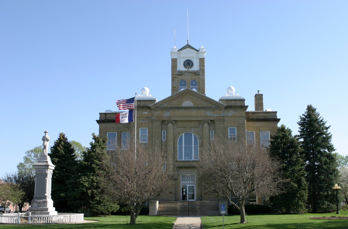
41°01′27″N 92°48′43″W / 41.024167°N 92.811944°WAlbia 7 Monroe County Courthouse 
July 2, 1981 Main St.
41°01′45″N 92°48′26″W / 41.029167°N 92.807222°WAlbia 8 Noble-Kendall House April 12, 1984 209 E. Benton Ave.
41°01′38″N 92°48′18″W / 41.027222°N 92.805°WAlbia 9 T.B. Perry House July 14, 1983 212 Benton Ave., W.
41°01′35″N 92°48′22″W / 41.026389°N 92.806111°WAlbia 10 Saint Patrick's Roman Catholic Church May 6, 1992 U.S. Route 34 west of Albia
41°00′48″N 92°57′20″W / 41.013333°N 92.955556°WAlbia 11 Arvine and Elizabeth W. White House September 8, 1994 309 N. Main St.
41°01′50″N 92°48′26″W / 41.030556°N 92.807222°WAlbia See also
References
- ^ The latitude and longitude information provided in this table was derived originally from the National Register Information System, which has been found to be fairly accurate for about 99% of listings. For about 1% of NRIS original coordinates, experience has shown that one or both coordinates are typos or otherwise extremely far off; some corrections may have been made. A more subtle problem causes many locations to be off by up to 150 yards, depending on location in the country: most NRIS coordinates were derived from tracing out latitude and longitudes off of USGS topographical quadrant maps created under the North American Datum of 1927, which differs from the current, highly accurate WGS84 GPS system used by Google maps. Chicago is about right, but NRIS longitudes in Washington are higher by about 4.5 seconds, and are lower by about 2.0 seconds in Maine. Latitudes differ by about 1.0 second in Florida. Some locations in this table may have been corrected to current GPS standards.
- ^ "National Register of Historic Places: Weekly List Actions". National Park Service, United States Department of the Interior. Retrieved on November 10, 2011.
- ^ Numbers represent an ordering by significant words. Various colorings, defined here, differentiate National Historic Landmark sites and National Register of Historic Places Districts from other NRHP buildings, structures, sites or objects.
- ^ "National Register Information System". National Register of Historic Places. National Park Service. . http://nrhp.focus.nps.gov/natreg/docs/All_Data.html.
U.S. National Register of Historic Places Topics Lists by states Alabama • Alaska • Arizona • Arkansas • California • Colorado • Connecticut • Delaware • Florida • Georgia • Hawaii • Idaho • Illinois • Indiana • Iowa • Kansas • Kentucky • Louisiana • Maine • Maryland • Massachusetts • Michigan • Minnesota • Mississippi • Missouri • Montana • Nebraska • Nevada • New Hampshire • New Jersey • New Mexico • New York • North Carolina • North Dakota • Ohio • Oklahoma • Oregon • Pennsylvania • Rhode Island • South Carolina • South Dakota • Tennessee • Texas • Utah • Vermont • Virginia • Washington • West Virginia • Wisconsin • WyomingLists by territories Lists by associated states Other Municipalities and communities of Monroe County, Iowa Cities 
Unincorporated
communityAvery
Ghost town Buxton
Footnotes ‡This populated place also has portions in an adjacent county or counties
Categories:- National Register of Historic Places in Iowa by county
- Monroe County, Iowa
- Buildings and structures in Monroe County, Iowa
-


Wikimedia Foundation. 2010.